|
Master Index & Glossary |
|---|
[ A | B | C | D | E | F | G | H | I | J | K | L | M | N | O | P | Q | R | S | T | U | V | W | X | Y | Z ]
Anasazi
|
The Anasazi was an ancient indian culture that inhabited various sections of the Grand Canyon between A.D. 700 to around A.D. 1150. The Anasazi followed or evolved from the Archaic or Desert culture which originally inhabited the Canyon between 2000 and 1000 B.C. Split twig figurines which have been found in many caves in the Redwall Limestone are among the oldest record left behind by the Desert Culture peoples.
The early Anasazi, dating from A.D. 1 to around A.D. 800, lived in pithouses in the area surrounding the Canyon, but they are not believed to have dwelt in the Canyon itself. They were primarily hunter-gatherers and had not yet developed a skill with pottery, but instead wove intricate baskets using the leaves of the yucca plant. This period is often referred to as Basketmaker. Sometime around A.D. 800 the Anasazi are thought to have entered their building phase and as a result, this marks the beginning of the Pueblo period, pueblo being the Spanish word for town. Around this time the Anasazi also began making crude pottery which eventually evolved into a much more sophisticated craft. They also started to blend their hunter-gatherer traits with those of a more agricultural nature. Areas such as Unkar Creek Delta and Obi Canyon in the inner canyon and Walhalla Glades on the north rim have provided archaeologists with numerous agricultural features, such as irrigation ditches, granaries, and stone tools such as metates and manos. Anasazi is a Navajo word that translates into English as meaning "enemy ancestor". The Hopi people are believed to be the modern descendants of the Anasazi. |
Arizona
Arizona Steak House
Babbitt's
Backcountry Reservations Office
Backcountry Trails
Bank
Bass Formation
Bass Trail
Bass, William Wallace
The Bass Formation is named after William Wallace Bass.
Beamer Trail
Beauty & Barber Shop
Berry, Peter D. Best Western Grand Canyon Squire Inn
Bill Hall Trail
Bonfiglio, Robert
Books
Boucher Trail
Bright Angel Campground
Bright Angel Canyon
Bright Angel Canyon in conjuction with its conterpart on the south rim is commonly referred to as "The Corridor" as it contains the primary north-south travel routes across the Canyon, those being the Bright Angel Trail, the South Kaibab Trail and the North Kaibab Trail.
Bright Angel Creek Bright Angel Fountain
Bright Angel Lodge
Bright Angel Restaurant
Bright Angel Shale
Bright Angel Trail
Bryce Canyon National Park
Butchart, Dr. John H. "Harvey"
Cameron, Ralph
It is important to note that the other primary routes into the inner canyon, the South Kaibab Trail and the Hermit Trail, were constructed as a means to bypass the toll being charged by Mr. Cameron.
The town of Cameron, just east of the South Rim's east entrance, near Desert View, is named for Ralph Cameron.
Camping
Canyon de Chelly National Monument
Canyon Food Mart
Cardenas, Captain Garcia Lopez de
Cave of the Domes
These caves are composed of limestone and are still alive in that the formations within them are still growing. Many formations have been damaged, however, by careless individuals who have entered the caves and either unknowingly or maliciously broken pieces off of them. If you do decide to visit the caves please treat them with the respect that they are due. Growth does not happen quickly and many of the formations have taken thousands of years to reach their present state and once damaged will require at least that long to recover.
Click here to view some photos of the caves.
Contact the Backcountry Reservations Office for information on visiting the caves.
cfs Cheyava Falls
Cheyava means "intermittent" in the Hopi language and the falls were named as such by Ellsworth Kolb.
The Clear Creek Trail was built by the Civilian Conservation Corps during the 1930s to allow guests staying at Phantom Ranch to visit the falls. The trip from Phantom Ranch to the falls is about 16 miles, one-way. The falls are located about 7 miles from the Clear Creek camping area.
Chuar Group
Children
Clear Creek Trail
Coconino Sandstone
Colorado River
Colter, Mary Elizabeth Jane
Continental drift
Coronado, Francisco Vasquez de
Corridor, The Cottonwood Camp
All camping must be in designated sights, no at-large camping is permitted anywhere in the area.
Use limits for the summer is for 1 group, or 6 parties, or 40 campers.
A party is defined as 2-6 people, and a group as 7-12 people.
Ribbon Falls is located about 1 mile south of Cottonwood Camp and Roaring Springs about 2 miles north.
Curios & Gifts
Curios
Deer Creek
Deer Creek is famous for two waterfalls and it's "Narrows" section [photo]. The first waterfall [photo] is actually not part of Deer Creek and is called Deer Spring or Dutton Falls. It is the tributary of Deer Creek that reaches up into the western end of Surprise Valley, and the falls occur right where Deer Spring spills over the cliff into upper Deer Creek. The second falls [photo] is definitely the more magnificent of the two and occurs right where the Deer Creek exits it's "Narrows" section and plummets down to the Colorado River.
Deer Creek Trail
Desert View Trading Post Fountain
Devil's Corkscrew Dining
Dox Sandstone
Dripping Springs Trail
Desert View Drive
Eco-tourism at Grand Canyon
Edge Of The Cedars State Park
El Tovar Hotel
El Tovar Dining Room
Entrance Fee
Equipment Sales, Rental & Repair
Equipment Sales
Escalante, Father
Escalante Route
Esplanade, The
The Thunder River Trail crosses the Esplanade as it heads from the rim, down into Surprise Valley and on to Thunder River.
Fauna
Film Processing
Fletcher, Colin Flora
Fossils Four Corners area
Fredonia, Arizona
Frequently Asked Questions (FAQ)
Fuel
Garage
General Store
Geology
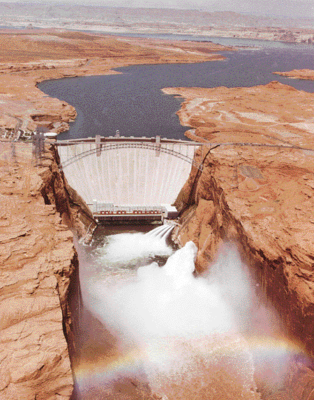
Glen Canyon Dam
Click here to see a photo of the dam.
Grand Canyon, The
Grand Canyon Caverns
Grand Canyon Chamber Music Festival
Grand Canyon IMAX Theatre
Grand Canyon Lodge
Grand Canyon Lodge Dining Room
Grand Canyon Railway
Grand Canyon Trading Post
Grand Canyon Trust
Grand Wash Cliffs
Grandview Point
In 1895 Peter Berry built the Grandview Hotel at Grandview Point. This was the finest lodging at the Canyon until the Santa Fe Railroad came up to the Canyon in 1907 and began construction of other lodging around the village area.
Grandview Trail
Granite Rapids
There is picture of the whole beach including the rapids here and another of the quiet section of the river above the rapids here.
Great Unconformity
Guided tour
Hakatai Shale
Hance, Captain John
One of Theodore Roosevelt's Rough Riders, a man by the name of Bucky O'Neil made an entry in the guest book at John Hance's ranch that reads "God made the cañon, John Hance made the trails. Without one, neither would be complete."
Harvey, Fred
Fred Harvey's claim to fame was the Harvey Girl concept, by which he made the Wild West a little less wild. His Harvey Girls were recruited from the eastern states and enticed by Mr. Harvey to move west to act as hostesses in his establishments. Upon arrival they were asked to sign a statement promising that they would not marry for a period of one year. This was necessary in those days as women were in very short supply and hence very great demand in the western states and Mr. Harvey needed to protect his investment. Harvey Girls were present at the El Tovar Hotel in it's heyday and were probably one of it's finest attractions.
The Fred Harvey Company is now the sole concessionaire for all establishments located within Grand Canyon National Park on the south rim. Anywhere you stay is operated by Fred Harvey. Anywhere you eat is operated by Fred Harvey. Just about anything you do from souvenir shopping to taking a mule to the bottom of the Canyon is controlled by Fred Harvey.
The Heard Museum in Phoenix, Arizona is running a lecture series in early 1996 entitled Fred Harvey's Southwest, and a large number of items from the Fred Harvey collection will be on display in an exhibit entitled Inventing the Southwest: The Fred Harvey Company and Native American Art. This exhibit runs from September, 1995 through May, 1997 and will also be touring some other museums in the United States beginning in June, 1997.
Havasupai Indians
The lifestyle of the Havasupai has remained almost completely unchanged since the Havasu Creek area was originally settled by their ancestors around A.D. 1300. Their name, Havasupai, means "People of the blue-green water" which describes the color of Havasu Creek.
![]() - B -
- B -
William Wallace Bass came to the Grand Canyon in 1884 for health reasons. He spent more than forty years living at the Canyon and during that time did some prospecting, got married and became the first person of European descent to raise a family at the Canyon. He is credited with building a road from Ash Fork, Arizona to his camp, Bass Camp, on the south rim, a distance of some 70 miles. He is a also responsible for the construction of both the North Bass and South Bass trails, which he used to guide tourists into the Canyon and over to the north rim. The trail was also used to haul asbestos out from his mine and to tend his garden near Shinumo Creek.
One of the canyons most successful prospectors. Founded the Last Chance copper mine on Horseshoe Mesa and used the proceeds from that to build the Grandview Hotel at Grandview Point.
Founder of the Grand Canyon Chamber Music Festival
Bright Angel Canyon is the largest tributary canyon of the Grand Canyon, running some 11 miles from the north rim to the Colorado River. There are two forces responsible for the creation of Bright Angel Canyon, the first being the Bright Angel Fault and the second being Bright Angel Creek. The fault is responsible for creating stress in the rocks which has in turn weakened them and made them more susceptible to erosional forces. Bright Angel Creek being a major erosional force has taken advantage of the situation to carve out the canyon and carry it away piece by piece down to the Colorado River.
Bright Angel Creek is the primary erosional force responsible for the creation of Bright Angel Canyon. It was given its name by Major John Wesley Powell during his first trip down the Colorado River through the Grand Canyon in 1869. It is said that he choose the name Bright Angel to counter a name given to another creek further up the Colorado River, that being The Dirty Devil.
![]() - C -
- C -
Ralph Cameron was one of the miners, during the 1890's, that improved the trail used by the Havasupai indians to reach their gardens at present-day Indian Garden. Later, when the trail fell into his control, he changed the name to the Cameron Trail and he operated it as a toll road into the inner canyon, charging $1 to anyone wanting to use it. The trail remained under his control until 1928, when after a number of legal battles, Coconino Country finally gained ownership of it. It was not until 1937 that the trail was renamed the Bright Angel Trail.
The Cave of the Domes is a cave that is located beneath
Horseshoe Mesa.
Abbreviation for "cubic feet per second" which is used as a measure for river flow rates.
Cheyava Falls [photo], the highest waterfall in the Grand Canyon, is located on the north rim and cascades down from the rim just north of Honan Point on the southern end of the Walhalla Plateau. The falls are impressive in the springtime when the water from snow melt cascades down over the Redwall Limestone, but they are dry during most other times of the year.
See Bright Angel Canyon.
Cottonwood Camp is a campground which is located on the North Kaibab Trail, about midway between Bright Angel Campground, at the river, and the North Kaibab trailhead, on the rim. A backcountry permit is required to camp here overnight.
Use limits for the winter is for 1 group, or 1 party, or 8 campers.
![]() - D -
- D -
Deer Creek is the primary drainage for the Esplanade and the western side of Surprise Valley.
The Devil's Corkscrew [photo] is the name given to a section of the Bright Angel Trail that occurs about midway between the River Trail and Indian Garden. The section is so named because the switchbacks resemble an enormous corkscrew, when viewed from the top. The other part of the name refers to the heat that can often be experienced along this section of trail during the summer, which typically reaches or exceeds 130 degrees fahrenheit (54 degrees celsius). This is not a section of trail to be toyed with.
![]() - E -
- E -
The Esplanade refers to a huge terrace that exists between Fishtail Mesa in the west, Bridger's Knoll to the east and Surprise Valley to the south, on the north rim. The terrace is composed primarily of Esplanade Sandstone and it's altitude varies from between 5600 and 5200 feet.
![]() - F -
- F -
Colin Fletcher is credited with being the first man (of European descent?) to have walked the entire length of the Grand Canyon. He recounts this story in his fabulous book entitled The Man Who Walked Through Time. The trip was completed during two months in 1967.
Numerous fossils, most of which are the remains of ancient sea creatures can be found in the rock layers that comprise the Grand Canyon. Among these fossils are brachiopods, crinoids, trilobites and nautiloids.
![]() - G -
- G -
The Glen Canyon dam stands at the head of Lake Powell. It was constructed in 1963 at a cost of $70 million dollars. 10 million tons of concrete, approximately 5 million cubic yards, were used in its construction.
The Grand Wash Cliffs mark the western end of the Grand Canyon and the beginning of Lake Mead.
Grandview Point is the highest point on the south rim at an elevation of 7400 feet. This is also where the trailhead for the Grandview Trail, which goes down to Horseshoe Mesa, is located.
Granite Rapids are the rapids that have been formed by debris being washed down Monument Creek. There is a very nice and very large beach area along the south side of the river and it has become a popular camping area for people hiking between along the Tonto Trail between the Hermit and Bright Angel Trails.
![]() - H -
- H -
Captain John Hance arrived at the Grand Canyon in the early 1880's and began mining asbestos in the vicinity of Asbestos Canyon on the north side of the Colorado River. In 1883 he constructed a trail down Hance Canyon to reach his mines, using an old Havasupai route as a base for the trail. In addition to his mining ventures John Hance also brought tourists down his trail and provided accommodations for them at his ranch in the bottom of Hance Canyon. In the late 1890's his trail degraded due to numerous washouts and he was forced to abandon it, at which point he constructed the New Hance Trail down Red Canyon to reach his holdings. The Old Hance Trail continues to elude all but the most experience canyoneers.
Not much mention is made of Fred Harvey [photo from Heard Museum] in works about the Grand Canyon. This is something that I find very odd as the company that now bears his name is omnipresent on the south rim and no one can visit the south rim of the Grand Canyon without his or her life being touched in some way by the Fred Harvey Company.
The Havasupai Indians are the only indigenous Canyon peoples that continue to live in Canyon today. They originally lived and farmed at present-day Indian Garden but were forced to leave this area when Grand Canyon achieved National Park status in the early 1900's. They now occupy a reservation that abuts the western side of the park and the village of Supai, on Havasu Creek is the tribal center.