|
The Colorado River |
|---|
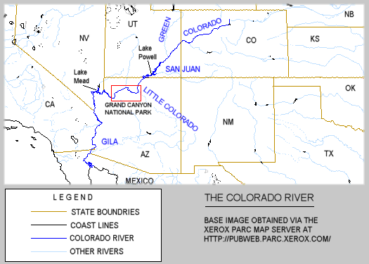
The Colorado River is the primary river of the American Southwest, draining somewhere in the vicinity of 242,000 square miles of land, from the states of Wyoming, Colorado, Utah, New Mexico, Arizona, Nevada and California. The Green River is the primary tributary of the Colorado River, and until 1921 the Colorado River did not technically begin until the Grand and Green Rivers joined together in Utah. In that year the Grand River was renamed as the Colorado River, at the request of the State of Colorado .
The headwaters of the Colorado River are located in Rocky Mountain National Park in Colorado. From here, at an altitude of 9,010 feet, the Colorado begins it's flow southwestward toward the Gulf o f California and the Pacific Ocean. By the time the river enters the Grand Canyon, at Lee's Ferry, its altitude has fallen to 3,110 feet, dropping over one mile since its beginning. The river will drop another 2,200 f eet before it reaches the other end of the Grand Canyon, the Grand Wash Cliffs, 277 miles away.
The river contains alternating sections of rapids and calm sections. The depth of the river varies from 6 feet to 90 feet, with the average being about 20 feet. The rapids are the shallow sections and the calm sections tend to be the deepest parts. Some deep holes have also formed at the base or foot of some of the more major rapids. The rapids represent only 10 percent of the river's total length through the Grand Canyon, but are responsible for more than half of the total drop in altitude.
The Colorado River was originally named Rio Colorado or "Red River" by the Spanish. A person looking at the river today may not understand how it came to be named in this way, as the present day color of the river is more of a blue-green. The reddish-bro wn color that originally gave the river its name become a rarity upon completion of the Glen Canyon Dam in 1963. The silt and sediments that gave the river its color are now trapped behind the dam in the bottom o f Lake Powell.
Before construction of the Glen Canyon Dam the river would carry 500,000 tons of silt and sediment per day, in an average day, through the Grand Canyon. The peak flow rate of the Colorado before construction of t he dam would normally be around 85,000 cfs for the month of June. By examining river sediments, scientists have determined that on a number of occasions over the past 4,000 years, the river reached peak flow rates of over 25 0,000 cfs. The peak flow rate through the Grand Canyon after construction of the dam was reduced to 50,000 cfs on rare occasions and is normally around 30,000 cfs. The primary purpose for construction of the Glen Canyon Dam was to prevent silt from building up behind another dam, Hoover Dam, on the other side of the Grand Canyon, at the head of Lake Mead.
Construction of the Glen Canyon Dam has adversely affected the ecology of the Grand Canyon. Flash floods that would at one time scour the inner-canyon clean and deposit fresh sand along the beaches no longer occu r. The water temperature, which used to get as warm as 80 degrees F, is now icy-cold all year and averages around 42 degrees F. Because of the changes in the water temperature some of native fish that used to inhabit the river have become extinct and sti ll others are endangered. The Rainbow Trout, a non-native specicies which was introduced by man, thrives in the colder waters and makes it even more difficult for the native fishes to survive.
|
|
|---|
|
|---|