|
Trail Description : Clear Creek Trail |
|---|
![]()
![]()
![]()
The Clear Creek area is one of the Grand Canyon's best kept little secrets. I hesitate to even tell people about it because I do not want to become over-crowded and spoiled as so many other popular spots in the Canyon have become. Unfortunately the Grand Canyon pages cannot be complete without this trail and so I must trust the people who are willing to venture into this remote area to help protect it.
The one thing that keeps the Clear Creek area so quiet and pristine is the fact that it involves a two day hike to get there. First you've got to get to the trailhead, which is one day hike itself and an overnight at either Bright Angel Campground or Phantom Ranch. It's possible that you could get from the trailhead of either the Bright Angel Trail or the South Kaibab Trail to Clear Creek in one day but it would make for a very long (20 miles or 18 miles, respectively) and tiring day. I am actually hoping to attempt this someday, just to avoid the crowds at Phantom Ranch and get an extra day at Clear Creek. The biggest problem here would be doing the trip out. It takes about a half day to get from Clear Creek to Phantom and then to have to hike up the South Kaibab or Bright Angel when you're already beat is not something I would look forward to. I guess it's good that it's so remote as it tends to keep the riffraff out.
Visiting the Clear Creek area gives you a nice idea of what Bright Angel Creek must have looked like before Phantom Ranch was constructed there. Clear Creek is much smaller (you can straddle it with a leg on either bank in some places) and does not carry anywhere near the flow of the Bright Angel but the settings are quite similar.
Mileages are as follows (one-way):
Elevations:
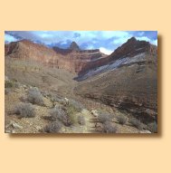
The trailhead for the Clear Creek Trail is located about a half mile north of Phantom Ranch. From the trailhead, the trail climbs rather abruptly, with the aid of a few long switchbacks, to the base of Sumner Butte. Just before the trail swings east to follow along the river, you will reach the Phantom Overlook, which is about half a mile from the trailhead. From here there is a great view of Phantom Ranch from about 1000' above and it's is a good place for a rest before continuing on up to the Tonto Platform, or if you're heading the other way, before heading down to Phantom.
From the Phantom Overlook the trail contours around the northern end of Sumner Butte until it reaches a spot where it can climb up to the Tonto Platform. This is a very interesting section of trail, as it skirts along the top of some very steep and wide drainages, draws, whatever that lead down to the Colorado. I have on occasion seen some Grand Canyon Bighorn hopping around in here. Once the trail heads around the eastern end of the second drainage it begins to head up onto the Tonto. At this point you are about 1.5 miles from the trailhead and about 7.5 miles from Clear Creek.
 Once on top of the Tonto the trail levels out and stays that way for most of the way to Zoroaster Canyon, about 6 miles away. There are some little ups and downs as it crosses drainages heading down to the Colorado but nothing major. Zoroaster Temple dominates the view if you are heading east. The next mile or so of the trail takes you right up into a drainage that comes down from between it's western and southwestern arms. When you finally reach the bed of this drainage you are about 2.5 miles from the trailhead and 7.5 miles from Clear Creek.
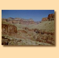 After you cross the drainage the trail heads briefly south before turning and again heading east. The next 3 or more miles find you contouring around the southern end of Zoroaster Temple. You will cross another drainage coming down from between Zoroaster's southwestern and southeastern arms (Bradley and Demaray Points) about midway along this stretch. After the trail passes the southern tip of Demaray Point it swings towards the north-northeast and begins to contour along Zoroaster Canyon. The bed of the drainage that flows down this canyon is still about a mile away.
Just before you begin the descent into Zoroaster Canyon the trail comes to a fairly flat area with some very large flat rocks that makes for an excellent rest/lunch stop. The view of Zoroaster Canyon, the Ottoman Amphitheatre behind that and Cape Royal behind that is magnificent. At this point you are past the halfway point at about 5.5 miles from the trailhead and 3.5 miles from Clear Creek. The worst is yet to come.
After you cross the drainage the trail heads briefly south before turning and again heading east. The next 3 or more miles find you contouring around the southern end of Zoroaster Temple. You will cross another drainage coming down from between Zoroaster's southwestern and southeastern arms (Bradley and Demaray Points) about midway along this stretch. After the trail passes the southern tip of Demaray Point it swings towards the north-northeast and begins to contour along Zoroaster Canyon. The bed of the drainage that flows down this canyon is still about a mile away.
Just before you begin the descent into Zoroaster Canyon the trail comes to a fairly flat area with some very large flat rocks that makes for an excellent rest/lunch stop. The view of Zoroaster Canyon, the Ottoman Amphitheatre behind that and Cape Royal behind that is magnificent. At this point you are past the halfway point at about 5.5 miles from the trailhead and 3.5 miles from Clear Creek. The worst is yet to come.
The trail heads down into Zoroaster Canyon and out the other side, no big deal. After a short climb the trail descends into and out of another nameless drainage just east of Zoroaster. This drainage flows down to Clear Creek but cannot be followed very far due to a very large falls. At this point you've got about a mile and a half left to go to Clear Creek.
The trail contours around the base of nameless arm of rock that comes down from Brahma Temple and shortly thereafter begins it's descent into Clear Creek. This section of the trail is not particularly pleasant. It contours along the face of crumbly shale slope and many parts of it are barely wide enough to walk on. The slope runs all the way down to the floor of Clear Creek Canyon but is too steep to walk down. There's also not much in the way of obstructions on it, plants, rocks or otherwise, so if you should slip here you're going all the way to the bottom before you stop.
Luckily that's the only bad part of the trail. Shortly after you get around to the backside of this arm the trail reaches another drainage feeding Clear Creek and begins a gradual descent to the canyon bottom along it's western side. This descent is also on a similar type of crumbly shale-like material but it doesn't seem to be as much of a worry as you get closer to the bottom. Once you reach the canyon floor it's about another quarter mile or so to the camping area, a beautiful little spot right next to the creek.
The Clear Creek area is one in which you can spend plenty of time. There are some very nice day hikes in that area that you can use to occupy yourself if you choose to stay over for a couple of days. One is the hike down along Clear Creek to the Colorado River. This is a 6 mile roundtrip. There are a couple of places on the way downstream that get a little tricky, falls to navigate around and the such, but the route is passable. Expect to get your feet wet.
Another nice trip is upstream to Cheyava Falls, the highest waterfall in the Grand Canyon. It is located up the northeast arm of Clear Creek just north of Honan Point. This is about an 8 mile roundtrip from the camping area. The trip up this way starts off difficult as the way upstream is clogged with a considerable amount of growth. It gets easier as you work your way upstream. Some route finding ability may be necessary going this route, to follow the correct water course, if Clear Creek is not running with a high volume of water. You should also expect to get your feet wet going this way.
|
|
|---|
|
|---|