Map for day 1
|

Day 0
|

Day 2
|
The day began early with a 5 a.m. wake-up call. This gave us two hours to get things in order and have breakfast before the O.A.R.S. team arrived to pick us up at 7 a.m. After a quick shower we stuffed the rest of our gear into the river duffels and carried it all down to the lobby. The breakfast at the Days Inn left a lot to be desired and we hoped that this was not an omen of what was to be for the remainder of the trip. Luckily, it was not.
At 7 a.m. on the dot the people from O.A.R.S. arrived with two super-long vans and started loading up our gear. Eight passengers would go in each van and Robby would travel about half the way to Lee's Ferry in one van and then the remainder of the trip in the other. He would travel in our van first and give us the low-down on the upcoming river trip. We also had another passenger in our van, Nancy Brian, author of RIVER TO RIM, a guide to place names along the Colorado River. She had just completed a private river trip and was hitching a ride back up to Lee's Ferry to pick up her car. She was also a botanist and it was very nice to have along for the ride. I used the opportunity to pick her brain as much as possible. Her book was invaluable to us throughout the trip and all of the guides had copies of it on their rafts to use for reference.
We stopped in Cameron for a short rest break around 8:30. The landscape that, less than an hour ago, had been a lush alpine forest had now been reduced to little more than desert scrub. We visited the little gift shop and deli, used the facilities and re-boarded our vans. Robby moved over to the other van to give his talk to the rest of the travelers during the remainder of the trip up to Lee's Ferry. Nancy was still with us and I continued to pick her brain.
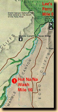
We arrived at Lee's Ferry about 9:30 a.m. While most of the O.A.R.S. crew prepared the rafts for departure, Chris gave us a little tour of Lee's Ferry. He showed us the remains of the trading post and fort, the post office, talked a bit about the history of Lee's Ferry and pointed out some of the landmarks in the area. One notable formation was a feature on the opposite side of the river called Lee's Backbone. This was a huge bed of Shinarump conglomerate which was highly inclined and provided access from the canyon rim right down to the banks of the Colorado River. This natural "ramp" was used by pioneers heading west, to descend to Lee's Ferry and cross the river. Until the Navajo Bridge was built in 1929, Lee's Ferry was the only way across the Colorado for hundreds of miles in either direction.
When we returned to the rafts the crew claimed that they were now ready to load our personal gear. Robby gave a brief talk about safety on the river and in the rafts after which we all choose our guides/rafts for the day and proceeded to transfer our gear to them. We ended up going with Kurt the first day, as did Carolyn and Ann. Before boarding the rafts many of us took some pictures of the group so we would all remember what we looked like at the start of the trip. It would be interesting to compare these with the photos taken at the other end. After that we donned our life jackets, boarded our rafts and set the rafts into the current. The time was about 10:30 and it was getting quite hot. I was looking forward to the first soaking already but Kurt informed me that it would probably not come until later in the day.
I kept my camera out and shot some photos of the rock layers as they began to rise up around us. Because of the way that the rock layers rise up around the river you are frequently given the illusion that the river is moving downhill at a much steeper angle than it really is and this can be slightly disorienting at times. Before we were less then a mile down-river the Kaibab formation had risen from beneath the Moenkpoi. It was very odd to see this rock layer at river level and even more disturbing to realize that it would be rising almost 5,000 feet above us during the next 5 days.
We also crossed the Paria Riffle, which was white-water but not forceful enough to be rated as a rapid, just before the end of our first mile. It was here that I learned an important lesson, which was that even a riffle can get you wet. We took a good splashing going through this and everything got wet, including my camera. I was quite disturbed and for a while a little concerned that it may have been damaged. I dried off the exterior as best I could, put the camera back into its bag and stowed it away in my ammo can. Hopefully I would get a chance to do a better drying during the lunch break, which was not that far away.
We continued down-river and the rock layers continued to rise above us. At the end of mile 2 the Toroweap formation rises from beneath the Kaibab. We stopped for lunch at small beach at around mile 3 which was just below 3 Mile Wash and the riffle created by it. I got the chance that I needed to give the camera a good drying. I took it out of the bag, out of the case and laid everything in the sun to dry. The case itself had absorbed a good deal of water and was quite damp. Luckily the sun was very hot and everything dried before lunch was over. Lunch itself consisted of sandwiches of cold-cuts and fresh veggies and we had cookies for dessert. After a break of about an hour we were back on the river.
As soon as we turned a bend in the river we saw the Navajo Bridge and its new twin looming ahead in the distance. At mile 4.5 we passed beneath them. Just beyond that the Coconino Sandstone rose up from beneath the Toroweap formation and before we hit mile 5 the Hermit Shale had risen as well. This was a very calm stretch of river and made for a very relaxing early afternoon cruise. The sun was hot but there was a cool breeze on the river blowing upstream. The scenery among the canyon walls was fantastic and I had to restrain myself with the camera. When I did take pictures I tried to get one or another of the rafts in them as well to show the scale of the place. Photos of the landscape itself are nice but a photo of that alone will not show the scale of what is around you. You need something man-made for people to relate to.
At just around mile 8 we hit our first rapid, Badger Creek, and took a little bit of a soaking. It was very refreshing but the sky was turning overcast now and it was very cool on the water. After two more miles of calm river we passed Ten Mile Rock and then a mile below that we hit our second rapid, Soap Creek, just below mile 11. Soap Creek was slightly more powerful than Badger Creek had been. The rest of the afternoon was very calm. We hit a few more small riffles and another rapid, Sheer Wall Rapid, at around mile 14.5. We stopped for the day, at just around 5 p.m., at a place called Hot Na Na Wash, near mile 16.5.
There was not much to do here in the way of exploring as the beach that we were camped on, was bordered by cliffs on one side and the river on the other. Robby gave a demonstration on how the tents were setup and then we all set off to find our own little campsites and set things up for ourselves. It was very interesting to watch our temporary little settlement take shape.
If dinner that first night on the river would be any indication of what we would be eating for the next two weeks, I would have no problem with this at all. For dinner that night we had Chicken Cordon Blue, which was roasted in Dutch Ovens, with corn-on-the-cob and rice on the side. For dessert we had strawberry shortcake. This is Robin's favorite dessert and she was in her glory.
Day 0
|
Day 2
|
| 


