Map for day 3
|
Day 2
|
Day 4
|
It rained again that night, on and off, a few times or more. The weather finally broke though, late in the evening, and I got up at one point to check out the view. I was amazed by the amount of light that the moon, which was very close to full, was giving off. The beach was very bright and the canyon walls were illuminated nicely as well. I went back into the tent to get my camera and tried to capture the subtle lighting on film to no avail, trying to take a time exposure without a tripod or at least a good solid base for the camera is futile.
In the morning the camp was a soggy mess and the wet sand on the delta had stuck to everything that had been left out. A great deal of it was stuck to and around the bottom of the tents. Everyone seemed to have settled into the morning routine very nicely by now and many people got up early and started packing some stuff up before breakfast and some tents were even taken down. After breakfast the rest of the tents were taken down and everything was piled up on the river bank next to the rafts. Breakfast was delightful this morning and consisted of that marvelous river coffee accompanied by banana pancakes. I learned from the guides that we would not be seeing much in the way of white water today but I also knew there were some nice stops along the way. The river was still running brown from all of the rain that we had received and I was not looking forward to running rapids of mud anyway.
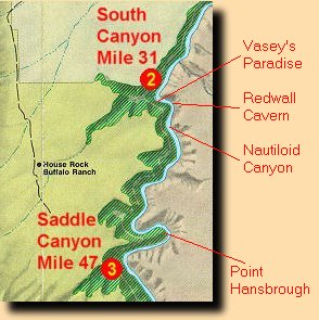
We were back on the river at our usual time, about 8 a.m., and today we would be travelling on the lead boat with Robby and again with Carolyn and Ann, who were very pleasant traveling companions. We passed by Stanton's Cave and stopped for a good look at Vasey's Paradise from the river but we did not get off there. The place is crawling with Poison Ivy and I don't think Robby wanted to take any chances so early in the trip.
About a mile below at Vasey's Paradise we came to at Redwall Cavern, a place that I have always wanted to visit and unfortunately is only accessible from the river. The cavern is huge but not as big as it was in at Powell's day because of the at Glen Canyon Dam. A great deal of sand has now accumulated in the cavern and there are no longer any spring floods to scour it clean. at Powell estimated the size by stating "if utilized for a theatre, would give seating to 50,000 people" which was probably even then an enormous exaggeration. You could probably pack 5,000 people into it but it would be a very tight fit. We managed to play a ball game in one end and there could have easily been 3 or 4 other games going on in it at the same time.
After two innings of baseball we took to the rafts again and headed downstream for a couple more miles. Our next stop was at Nautaloid Canyon, which is another one of those fascinating places that you can only get to on a river trip. Nautaloid Canyon was named for the fossil nautaloids that can be found in the rock along the canyon's floor and walls. There are a number of very nice specimens that are very easy to locate. If you look around and study the rocks you can find dozens of other examples that are not quite as obvious but equally as nice. Nautaloid Canyon does not require much of a hike to get into and it is really only a short scramble up a small cliff that is located right at the mouth of the canyon.
After a nice visit with the fossil nautaloids we took to the boats again and set out for Buck Farm Canyon. Along the way we ran through 36 Mile Rapid which was nothing much to boast about. Buck Farm would be our lunch stop and then we would go on a short day hike after we finished eating. Lunch was very good consisted of tuna fish sandwiches with all kinds of fixings to add. The hike up Buck Farm Canyon was very pleasant and we saw lots of Red Columbine in bloom.
Back on the river we passed below the Royal Arches which looked more like alcoves than arches and then we ran President Harding Rapid about 2 1/2 miles below Buck Farm. This was not much of a rapid and Robby commented that it was only fitting seeing that Harding was not much of a president. We also passed an old Anasazi footbridge that was high up in the cliffs and was used to bridge a ravine along an ancient river route. The river takes a sharp bend around Point Hansbrough and it is a very scenic section of the river. After about 3 1/2 more miles of calm water we passed the Triple Alcoves which interestingly enough looked more like arches. Maybe someone got the names of Royal Arches and Triple Alcoves mixed up at some point? Beyond the arches, alcoves, whatever, we made camp for the day at Saddle Canyon.
While the others were setting up camp Andreas, one of the Germans, decided to build a Formula racing car out of the sand next to their campsite. It came out very nice and I could not resist taking a photo of him at the "wheel".
After camp was established we went on a short day-hike up Saddle Canyon which was led by Chris. The hike was tough at the start, as we had to gain a few hundred feet in elevation to get up into the canyon. Near the top of this climb Chris pointed out a Devonian river channel that was fossilized in the cliff on the north side of the canyon. I found this very interesting and kept looking for its continuation on the south wall but could not find it, as there was a steep debris slope on that side which was obscuring it. It found it interesting that another river existed here so long ago that, at least along this point, seemed to be following a course close to the present day Colorado.
Continuing along on the hike we came across a small herd of deer further up in the canyon. I thought that they were mule deer but I think Chris said that they were White-tails. I've seen plenty of deer in the canyon but it was interesting to watch the reaction of some of the others in the party who had apparently never been this close to them before.
Shortly after the encounter with the deer we came to the terminus of the hike, a gorgeous little alcove with a moss and fern draped waterfall. There was a nice little pool in front of the fall and many people went for a quick dip to cool off from the hike. We had a small cliff to contend with before we could get up into the alcove but we all got up around that without incident. The guides were very helpful about things like that. They have all done these side canyon hikes dozens of times and know all the tricks about getting into these places. After a nice relaxing visit at the waterfall we made record time in getting back to camp. I think we all knew that dinner would be waiting for us and we wondered what was in store for us tonight.
Dinner turned out to be spaghetti, garlic bread and spinach salad. Robin was thrilled as she loves pasta and she was not at all interested in the blackened salmon the night before. For desert they managed to bake brownies in one of the Dutch ovens and they were wonderful. They also broke out a can of whipped cream to top off the brownies with. Yum! Where do they come up with this stuff?
Day 2
|
Day 4
|
| 


