Map for day 5
|

Day 4
|

Day 6
|
The morning was beautiful and there was not a cloud in the sky. This promised to be an exciting day on the river and I could not wait to get started. Again we would be travelling through an area of the Canyon that I was very familiar with and I was eager to see what it all looked like from river level. The main section of the Canyon between Tanner Rapid and Hermit Rapid was extremely familiar and I had camped many nights on the beaches along the way. Today we cover about half of this stretch of the river and tomorrow we would finish it off.
Coffee and breakfast were both ready right on schedule as usual and the wonderful omelets of mushrooms, tomatoes and onions more than made up for the cream of wheat fiasco of the prior morning. After breakfast we still had a little time before departure and so Robin and I went over to visit the McCormick Copper Grant Mine, which was right next to where our party was camped. The timbers in the mine still appeared to be in remarkable good condition so we ventured back as far as we could go. The mine was not very deep, however, and after about 50 or 60 yards we came to a dead end. There was one 90-degree turn along the way and near the back of the mine it appears that a shaft heading down had been started but never completed. I wonder if anything was ever taken out of the McCormick mine or if the tunnel was just a test bore.
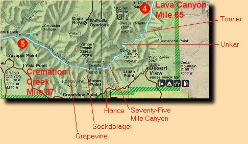
We took to the river again right at 8 a.m. drifted south towards Tanner Rapid and Desert View, the watchtower being visible along the way, though only a speck among the cliffs. The sun was bright but the morning was still cool. Today we were on Kurt's raft and we were again travelling with George and Hilary. We ran Lava Canyon Rapid right off but it was not much of a ride, nothing at all compared to what would be in store for us later in the day. At one point we drifted within hearing range of Robby's raft and I could hear him begin reciting a well known portion of text from Powell's journal that was written when he passed through this section of the Canyon on his first expedition back in 1869:
|
August 13 - "We are now ready to start on our way down the Great Unknown. Our boats, tied to a common stake, chafe each other as they are tossed by the fretful river. They ride high and buoyant, for their loads are lighter than we could desire. We have but a month's rations remaining. The flour has been resifted through the mosquito-net sieve; the spoiled bacon has been dried and the worst of it boiled; the few pounds of dried apples have been spread in the sun and reshrunken to their normal bulk. The sugar has all melted and gone on its way down the river. But we have a large sack of coffee. The lightening of the boats has this advantage : they will ride the waves better and we shall have but little to carry when we make a portage.
We are three quarters of a mile in the depths of the earth, and the great river shrinks into insignificance as it dashes its angry waves against the walls and cliffs that rise to the world above; the waves are but puny ripples, and we but pigmies, running up and down the sands or lost among the boulders.
We have an unknown distance yet to run, an unknown river to explore. What falls there are, we know not; what rocks beset the channel, we know not; what walls rise over the river, we know not. Ah, well! we may conjecture many things. The men talk as cheerfully as ever; jests are bandied about freely this morning; but to me the cheer is somber and the jests are ghastly"
-- John Welsey Powell
|
It was a short ride down to Tanner, only about 2 1/2 miles, and we pulled over just above the rapids on the right bank to check out some petroglyphs. It was a very nice morning for a walk and everybody seemed to be in wonderful spirits. The walk up to the petroglyphs was only about 1/2 mile and took us up a small hill which offered a fantastic view downstream of Tanner Rapids and beyond. We milled about for a short while, inspecting the main set of petroglyphs and looking for more, and then headed back to the rafts. We all put on our rain gear before getting back on the rafts as today would definitely be a day for getting wet. We ran through Tanner Rapid as soon as we took to the river and it was a very enjoyable ride. Tanner Rapid grew considerable a couple of years earlier when a flash flood came roaring down Tanner Canyon and deposited a great number of very large boulders right in the main channel of the river. The guidebook that we had still listed it as being 2-4 but it is probably more like 4-6 now.
Beyond Tanner there was a wonderfully calm stretch of river and the scenery on either side was fantastic. The colors and the shadows created by the early morning light playing among the slopes and cliffs were an awesome sight and it was delightful to be simply floating among and through this landscape. It was all so very familiar to me because over the past 10 years I had walked this entire stretch of river, some sections more than once. The rapids were familiar, as were the beaches, the cliffs, the buttes and mesas... all of it. It will be interesting walking it all again after having done it all by river. We encountered a couple of small riffles as we came around the bend in the river near Basalt Canyon but that was nothing much to speak of. I could see very familiar rock formation rising directly ahead of us, the cliffs of the Unkar Creek overlook, and I knew that Unkar Rapid was just on the other side of this. I had been to this location on two other occasions as watch as river trips would run this rapid. My vantage point at that time however was from the top of the cliffs, about 3-400 feet above the river, looking directly down on the rapid.
In no time at all we were racing through Unkar Rapid which was the best ride yet of the day. The guides were beginning to get more cautious about the rapids and would stand in the rafts and scout them before running them, looking for just the right entry point to carry us through safely and yet still give us a ride for our money. Unkar, they claimed could be a dangerous rapid because of the sheer wall on one side and the tendency for the current to want to carry you up into it. It took some strong strokes of the oars to keep stay just to the right of the main channel and keep the raft from getting slammed into the cliffs. We all made it through without incident. On the other side of Unkar were a couple of good sized ripples that gave us a good splashing. The channel of the river had now narrowed considerably and the cliffs came down to water level and began to soar above us as we began to close in on the Upper Granite Gorge.
We pulled over at Seventy-Five Mile Creek, just above Nevills Rapid, for lunch and a nice day-hike. Lunch was simple and consisted of sandwiches of cold-cuts which were easy to prepare and easy to eat. After a few cookies for dessert we headed off and followed Robby up Seventy-Five Mile Canyon. This side canyon was part of the Escalante Route and I had been up here once before on a day-hike from Red Canyon to the Unkar Creek overlook. The canyon is very narrow and the walls soar up hundreds of feet on either side. We hiked up the canyon for maybe 3/4 mile and did some small climbs over dry falls and small cliffs before we came to a fairly high cliff. This was definitely the most difficult climb that we had encountered thus far and it seemed that the guides were testing us to see what the group was capable of. Each day-hike and climb seemed to be getting slightly more difficult. This one seemed more like a lesson plan for Rock Climbing 101 but we all passed with flying colors for the trip up the cliff. A short distance beyond the cliff there was another climb up a rocky slope that took us well above the canyon floor. Once on top we milled about for a bit and I found the upper portion of the Escalante and started following it a little ways back towards the river. This proved to be a great vantage point for watching people climb up from below. It was now starting to get very hot and I searched out a bit of shade to sit down and relax a bit. There was not much shade to be had up here as the sun was almost directly overhead.
The climb back down proved to be considerably more difficult than the climb up had been. I managed to find a much shorter and easier way down the upper rocky slope by following the Escalante Route itself but the cliff was another story. It's a lot more difficult climbing down something like that when you can't see where you are putting your feet. The guides helped us out as best they could but some people still had serious difficulties with it. It took time but we all made it down safely. Once past the cliff the hike back to the river was easy. Near the river I spotted some trees which I had thought were mesquite when we passed them on the way up but now discovered that they were something completely different and were called Catclaw. We boarded the rafts and prepared for some of the best whitewater of the trip.
The first run through Nevills Rapid was a great start and very energetic ride. Shortly beyond Nevills Rapid the river took a small turn towards the north and I could see the vibrant red color of the Hakatai Shale that marks Red Canyon and Hance Rapid at its mouth. In no time at all we were there and started our run through Hance Rapid. Hance was very exciting, had lots of big waves and the rafts were thrown around quite a bit. I was riding in the back on this day and we had three people up front to keep the bow down as we crashed through the waves. From my vantage point I could see the bow of the boat climbing up the sides of the waves quite a way before we would finally crash through them and slide down the other side. Hance was truly a wild ride and one of the best rapids that we would run on the entire trip. Rapids like Crystal and Lava Falls were just too scary and you could not go for the really wild ride in a small raft without fear of loosing people along the way. The guides tended to be much more cautious in these types of rapids.
Just beyond Hance Rapid the Vishnu Schist along with its intrusive dikes of pink Zoroaster Granite finally emerged from the depths of the Earth as we entered the Upper Granite Gorge. The river was really narrow now and the walls were sharp and steep. We passed through a couple of fairly sizable riffles on our way to Sockdolager Rapid, the next big ride, about two miles down-river from Hance. The river was moving quite swiftly through the gorge and we covered this distance in no time at all. The ride through Sockdolager Rapid was almost as nice as Hance though not quite as wild. There was no beach on either side of us here and the rapid just raced through the granite walls. Beyond Sockdolager the river settled down quite a bit and was very calm though still very swift. Grapevine Rapid was still three miles away and we had a good chance for a rest.
As we approached Grapevine Rapid Kurt filled us in on a secret, a practical joke of Fabry and Robby that had been a long time in the works. It seems that Fabry had this idea some time ago about making a video, on a river trip, that would be suitable to submission to the America's Funniest Home Videos television program. The gag involved making the raft passengers on a whitewater trip think that their oars-person had been washed overboard while running a rapid. The idea was to see what the passengers would do and who of them would try to take control of the raft. Fabry had singled out the group of Germans who were travelling with us to be the victims of this hoax right from the start of the trip. Robby was also in on this and the plan had been already set into motion. Robby, being the trip leader, was always the lead raft and he had the video camera and was responsible for recording the episode. To give Robby enough time to set things up the other oars-persons had put a lot more space between the rafts than usual as soon as we came out of Sockdolager Rapid. We were the in tail raft following behind Fabry and would get to see it all from behind. The first part of the gag involved getting all four of the Germans into the front of the raft, as having one of them riding in the back would not work for this stunt, that's where Fabry needed to hide, behind the baggage. To accomplish this Fabry told them that the next rapid was an extremely violent one and that he wanted as much weight in the bow of the raft as possible. In actuality the rapid was not very dangerous at all, it had a lot of water being tossed about but any rocks that were in the channel were well submerged. He also instructed them to keep their eyes forward and to watch for big waves that they may need to lean into to keep the bow down. No humans were harmed during the making of this video. Now we just had to wait.
As Fabry approached Grapevine Rapid we could see all four of the Germans sitting in the front of his raft. As soon as Fabry's raft started down the chute of water, that he had chosen for his run, we saw him leap from the oars and duck behind the stowed baggage in the rear passenger compartment. The Germans never knew what happened and it took a few seconds for them to realize that no one was at the oars of their raft. They looked at each other and seemed somewhat confused but there was apparently no concern for the fate of Fabry, only themselves. I believe that it was Peter who attempted to take the oars and bring the raft under control. But as soon as he tried Fabry jumped up from behind the rear compartment wearing a gorilla mask. The scene was hilarious. Robby supposedly got it all on film and I cannot wait to see the results. If it comes out good I will try to post it on this web site at a future date.
Once below Grapevine we ran a couple of smaller rapids, 83 Mile Rapid and Zoroaster Rapid. Both of these had some very nice whitewater on their own, but they were a bit on the mild side compared to what we had just been through. We ended the day just west of Cremation Creek, about 1/2 mile from the boat beach near Bright Angel Creek and Phantom Ranch where we were scheduled to swap passengers on the following day. The Germans would end their trip there, after a very enjoyable five days, and hike back out to the rim, and a new group of four people would be hiking in to replace them.
Our camp that night was very enclosed, with the river on one side and cliffs on the other side, and there was nowhere to go. We all just hung around and talked and drank and ate appetizers and waited for the guides to prepare dinner. For dinner that night we had filet mignon with mashed potatoes and salad. We had a little going away party for the Germans after dinner and the guides managed to bake a chocolate cake for them in one of the Dutch ovens. The group from New Zealand had come up with a little show that they wanted to put on for them, which involved singing a song that Lee and Janine had written, and the men doing some Maori (aboriginal New Zealander) war dance called a Haka. After that was over we all hung around for a little while longer and then people began drifting away to get some sleep. It had been a very exciting day on the river.
Day 4
|
Day 6
|
|


