Map for day 4
|

Day 3
|

Day 5
|
Well, everyone should be allowed to make a mistake once in a while I guess... breakfast this morning was Cream of Wheat cereal and I am not really sure what was wrong with it but it just didn't seem right and was not very appetizing at all. It cooled off too quickly and I think it also may have been overcooked and as a result ended up too much on the dry side. There was also yogurt, granola, nuts and raisins and I had to mix some of this other stuff in with it just to get it down. Robin just had some of the granola and she liked her breakfast just fine.
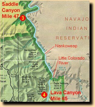
We left Saddle Canyon right around 8 a.m. and headed down-river to Nankoweap, arriving there around 9 a.m. Today we were travelling on Fabry's raft with George and Hilary. The mood of the trip changed considerably for me today as I myself was no longer in virgin territory. I was now in a part of the Canyon that I was familiar with and the Nankoweap area was very fresh in my mind being that it was the last backcountry hiking trip that I had done here. I hiked down the Nankoweap Trail in October 1996 to visit the granaries and do some other exploring in the area and the trail is a killer. The Park Service lists it as being the most difficult of the named Canyon trails and after hiking it I can see why. The trail is long, covered with brush, has a considerable amount of exposure, and in places is extremely steep, almost to the point of being more vertical than horizontal. My feet did not recover from that hike for many months afterwards.
At Nankoweap we hiked up to visit the granaries that the Anasazi had built into the cliffs along the northeastern face of Nankoweap Mesa. We were lucky in that the morning was overcast and there was no sun beating down on us while we were climbing. The hike was actually quite cool and pleasant. The trail up to the granaries gets very steep near the top and when I was last here it was in full sun and the climb, about 400 feet above the river, was brutally hot. We also lucked out in the fact that there was almost no air traffic today. It may just have been because it was still early and no one was interested in the morning flights but it was definitely unusually as the Nankoweap area is usually notorious for being busy with overflights. The last time that I was here there was no end to them.
It was interesting being here with such a large crowd but I must say that I enjoyed the company. When I am hiking in the Canyon I usually prefer to go it alone and relish in the serenity and solitude of the places that I visit but travelling on the river makes for a different mood and a different feeling and it's nice having the people around. When I was here in October 1996 there was also a small private river trip visiting at the same time but they left before I did and I had the place to myself for a while.
After a couple of hours at Nankoweap we re-boarded the rafts and set off down-river again. We ran Nankoweap Rapid right off and then had a few miles of fairly calm water until we got to Kwagunt Rapid. The ride through Nankoweap was not very active but it was nice because it is such a long rapid, about a quarter of a mile in length. Just below Nanoweap there are some very nice and very colorful outcroppings of Bright Angel Shale, one of which resembles a sort of a castle or temple of sorts. Kwagunt Rapid was a slightly more exciting ride and we pulled over just below the rapid for our lunch break. I went for a short hike up into the mouth of Kwagunt Valley while lunch was being prepared. When I was down at Nankoweap the past October I had intended to do the Nankoweap/Kwagunt loop hike but after the descent to Nankoweap Creek from the rim my feet were in no shape for this. After seeing Kwagunt Valley I decided that I would have to come back on foot again, even though I had promised myself that I would have no further use for the Nankoweap Trail. Lunch consisted of Middle-Eastern fare, humus and tabouli served on pita bread, with all kinds of veggies and condiments on the side. I enjoyed it but Robin was not interested and she headed for the PB&J again. The guides either made too much or we did not eat enough as there was plenty of the tabouli left over. Robby kept trying to get us to eat more by saying that if we didn't we would see it again. We didn't and we did.
Shortly after lunch we encountered a group of scientists from the WRMCS (Western Region Marine and Coastal Surveys) who were conducting research on the after effects of the simulated spring flood that was done in March of 1996. The leader of this expedition, Larry Stephens, who is also the author of the guide book that we were using the trip, The Colorado River in Grand Canyon, A GUIDE, agreed to give us a short talk regarding the research that he was doing. He told us where his camp was setup downstream and said the he would meet us there shortly. The talk that he gave was interesting and the research that he was doing consisted of studying the sediment layers in the backwaters along the Colorado River. His group was busy taking core samples in the various backwaters which would then be taken back to his laboratory for analysis and cataloging. The focus of the study had to do with how often the simulated floods should be repeated to keep the inner canyon ecosystems healthy and by studying the historical sediment layers he hoped to gain some insight into the spring floods of the pre-Glen Canyon Dam period.
My own views of the success of the simulated spring flood changed greatly as a result of this river trip. Robin and I did a backcountry trip over to Clear Creek in May of 1996, right after the flood, and had a first hand opportunity to inspect the results of the flood at that time. Back then I thought that the flood was a major success as many of the beaches had seen a dramatic increase in the amount of sand that had been deposited on them. Since the beaches and sand bars were now bigger this meant that the resulting backwaters that were formed behind them were also much bigger. Things had changed quite a bit in the past year however and many of the beaches had already reverted back to their pre-flood state. The flood also had some negative impacts as we would shortly discover on the beaches in the lower canyon, which had to do with the proliferation of an intrusive plant species known as camelthorn. The spring flood had purposely been scheduled when it was so as to not be done when the tamarisk, another non-native and intrusive plant species, was in seed, so that it would not be spread into the Canyon any more than it already has. The camelthorn, however, was in seed and has now taken over many of the beaches in the lower canyon. This plant is even more intrusive than the tamarisk and it will also rip you to shreds if you try to walk through a location that it has taken over. Our trip leader, Robby, had a personal vendetta going against the camelthorn and he was frequently seen with shovel in hand, attacking a patch of it, ripping it out and hauling it down to the river for disposal. It's obvious that a lot more thought needs to be put into conducting future floods.
Back on the river our next stop was the LCR, as the river runners call it, or the Little Colorado River, as everyone else would know it. On our way down to the LCR we had mostly calm water and only one small rapid, 60 Mile Rapid, which was nothing to speak of. The guides were very surprised to see that the LCR was running its clear, turquoise color since the main Colorado looked more like chocolate milk. They said that this was extremely unusual and that we should take full advantage of the situation. This screwed up our plans for the rest of the day as the guides had expected that the LCR would also be muddy and that we would just take a quick look and float on by. As it was we had an incredible time hiking along the LCR and body surfing some of the small rapids in it. I also finally got to see the Beamer Cabin which I had tried to reach once before back in December 1994 as a day-hike from my campsite at Tanner Rapids. To body surf in the Little Colorado we were required to put on our life jackets upside down, i.e. put our legs through the openings where our arms would normally be. This was to keep your rear end afloat and also cushion it from any encounters with submerged rocks. The resulting show was hilarious as everyone seemed to be wearing huge orange diapers. NO, I did not take any pictures and I certainly hope that no one else did. :-)
After a couple hours at the Little Colorado we head down-river for our camp for the night. The original plan had been for most of us to disembark at Carbon Creek and do a hike up Carbon Creek, over to Lava Canyon and then down Lava Canyon to meet the rafts again. The guides claimed that we had no time left for this and so we just headed for Lava Canyon and made camp on the beach there. Part of the problem also had to do with the fact that there were a number of parties at the Little Colorado and very shortly they would all be looking for places to camp for the night. We got a head start on all of them and claimed the prime camping location south of the LCR.
After setting up camp we had plenty of time for a short day-hike up Lava Canyon. Robin and I took off with Bryce, Lee, George and Hilary to explore a bit up the canyon. The bed of the wash was quite muddy and had a small stream of very muddy water flowing down it, which made the hike somewhat of a challenge. We didn't go very a far, maybe a mile or so, and then turned back. We did find a very big rock and managed to coax Bryce into climbing it so that we could take his picture. On our way back to camp we encountered some others who had taken off for a bit of a walk. Andreas and Peter were wandering around taking pictures and video and Harald and Nigel were building a dam across the wash, and already had a good size pool of water behind it.
Back at camp we had roast turkey with stuffing, sweet potatoes and salad for dinner. The cooks continue to amaze me. It had been a very busy day and it seemed that we all hit the sack earlier than usual that day. Tomorrow would be a fun day with lots of really big whitewater: Tanner, Unkar, Hance, Sockdolager and Grapevine. This was one of the days that I had really been looking forward to and I hoped the weather would cooperate for us. I went to bed as well...
To sleep; perchance to dream. Ay there's the rub;
For in that sleep of death what dreams may come,
When we have shuffled off this mortal coil,
Must give us pause--there's the respect
That makes calamity of so long life.
-- from Hamlet (Act 3, Scene 1) by William Shakespeare
|
Day 3
|
Day 5
|
|


