|
"The Canyon Trip Promised to Matthew Huggins" |
|---|
|
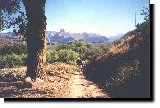
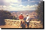
Wednesday, August 13, 1997: Hike to Indian GardensAnother of those fine Phantom Ranch breakfasts woke us up in the pre-dawn dark. We said good by to father and son Smith and to Tim Chizak. Those strong, healthy and young men would leave us far behind on the hike out. Pete Smith, in his 50s didn't consider himself young, but we assured him that 50s are a lot better than 60s for the sort of thing we were doing. Sixties aren't so bad, if you are world class like the famous University of Northern Arizona math professor, Harvey Butchart, who became one of the most famous Canyon explorers. He could out-hike college kids well up into his 70s. People like Harvey: however, are from another planet. Don't expect to do as they do any more than you would expect to compete with Edwin Moses in the hurdles, or Pete Sampras in tennis. Admit your age, and your limitations. Pace yourself. That's the key. A little known fact, or at least one that nobody seems to comment on, about the fine food at Phantom Ranch is this. The menu never changes. Therefore, in case you plan to spend a week down there - as we did one time, be forewarned. Scrambled eggs, biscuits, bacon, coffee and pancakes - all you can eat - for breakfast, and a great, thick, tender and juicy steak for early supper, or a spectacular beef stew - again -all you can eat, for late supper. Both evening meals are followed by a desert of chocolate cake. The food is well prepared and delicious, and really hits the spot with the kind of exercise you are bound to get down there, but it is always the same - year after year. At the beginning of our hike out the Huggins and I were a delayed slightly by a couple of silly things. First, I couldn't find my hiking stick. I finally remembered that the night before I had taken it with me when I had carried my duffel back behind the Mess Hall to have it weighed and stored there to be picked up by the mule train. Also I remembered the pleasant conversation with the maintenance man, Paul, who has lived at Phantom Ranch for the past 9 years. He's as friendly and helpful a person as you will ever meet. As I usually do, being mildly distracted by the relaxing conversation, I forgot my cane when I returned to our cabin. I found it right where I had left it, leaning against the back wall of the Mess Hall kitchen. Second, we took the short cut across the upper bridge to the Bright Angel campground. Short cut? We decided that to walk down the east side of Bright Angel Creek, because it was the most direct route to the Silver Bridge across the Colorado. The Silver Bridge, actually aluminum and steel, is a couple of miles west of the Black Bridge which the mules use, and is on a direct route to the part of the River Trail that we would take up to Pipe Creek, and out. It usually is the most direct route, but not this day. We had to hike all the way down through the camp ground, almost to the end of the trail to find that it was still blocked. The final few hundred yards here had been washed out in the big flood of March of 1995. When we were here with Al Roberts, the brother of my medical colleague Phil, and Rawson Hobart, my son-in-law, in September of 1995 we had known that this part of the trail had been washed out. We had hiked down, and inspected the site. It appeared to us that reconstruction of the damaged part was well under way, and - as a matter of fact - nearly complete. And that had been nearly 2 years ago. It didn't occur to us that this year the trail would still be blocked. There were no signs at the upper end of the trail to warn us, so we had blithely walked half a mile through the campground to the blocking fence. That meant another half mile hike back to the upper bridge, to cross over to the west side of the creek, to hike down to the lower bridge, to cross back to the east side of the creek, to . . . well . . .you get the idea. Mainly it was RATS! RATS! RATS! And my knee was sore already. However; this extra hike of our non-shortcut was what made me run into Nina, and made it possible for me to get her address. Something good always seems to come out of something bad, doesn't it. Sometimes you have to look pretty hard for the good, but it's there if you keep yourself in the right frame of mind. Down canyon, at the silver bridge, we took some pictures, and explained to Matthew that the silver bridge had been built in 1966 to conduct the water pipe from the north side to the south side of the Colorado. Water for the South Rim was originally transported by the Santa Fe Railroad. In 1932 a pumping station and pipe line brought water up from Indian Gardens, but by the 60's even that was inadequate, and the Park Service had to supplement Gardens' supply by hauling water in to the storage tanks by tank car again. A new pumping station was then built at Roaring Springs, near the North Rim - 11 miles up the Bright Angel Canyon from Phantom Ranch, and water was brought all the way down to the Colorado, across the river under the Silver Bridge, and finally up to the South Rim by that means. The great 1966 flood that created the dangerous Crystal Rapids, washed out a lot of the pipe line, just before it was completed, and they had to pretty well start all over again. At last, in 1970, the project was finished, and except for temporarily being interrupted by the flood of March, 1995 the service has been unbroken. Bruce Aiken, a Park Ranger, and very fine artist, - who grew up in Greenwich Village, and studied at the Manhattan Art School - (I have a copy of one of his paintings) has kept the pumping station in good working order for the past 23 years or so. His kids set up a lemonade stand in his back yard, (which is adjacent to the North Kaibab Trail almost at the junction with Roaring Springs Canyon) way back in the 70's. They served free lemonade to tired, and thirsty hikers who found the shady cottonwoods in the Aiken's' yard a pleasant place to rest. All that was asked was that hikers leave a contribution in a box that was set beside the lemonade. Most of the time there is no one there to watch it. It is all on the honor system, but it has worked for all these years. Bruce's and Mary's kids are now grown, and in college or beyond, but the lemonade stand has become such a fixture that the Aikens find that they can't discontinue it. The Roberts brothers, Bill Huggins and I met Bruce at his lemonade stand on our hike to Cottonwood in 1994. That's when we learned all of this. Following our picture taking session we hiked up the River Trail, sometimes along the cliffs and sometimes over sand dunes until we came to Pipe Creek. Along the way we had a good view of some rafters at their camp site far below us. Matthew wanted us to take a picture on one of the guys down there sitting on their portable john. The John was placed in a spot well concealed from the other campers, and well concealed from the river, but in plain view form the River Trail high above. I wonder if the guy knew that. Deciding to respect his privacy, if not his privates, we continued on. I paced off a mile up to the mouth of Pipe Creek where there is a rest house and new chemical toilet. Back in 1894 when Ralph Cameron was on a hike from the Grandview Trail to the Bright Angel Trail, called the Cameron Trail in those days, because he and a couple of his friends had built it, (you guessed it, by improving an old Indian trail) in order to get equipment down to their mines, he found an old Meerschaum pipe at the head of this creek. As a joke he scratched a date 100 years earlier on the pipe, and then left it in plain sight so that his friends, Pete Berry and James McClure would find it. Naturally they did, and began to discuss who in the world could possibly have been in this area so long ago. After having a good laugh, Ralph told them what he had done. The Creek has been known as Pipe Creek ever since. I next paced off about another mile up Pipe Creek past Columbine Springs to the beginning of the Devils Corkscrew. Columbine Springs is a sort of miniature water fall that comes out of the cliff on the west side of the canyon. There is enough water all along this section of the trail to provide a pleasant riparian habitat, and we have often seen deer, big horn sheep, squirrels and a variety of birds along this area. Once again Bill was the first to spot a couple of deer. The Devils Corkscrew is a series of switchbacks up through the Vishnu Schist to the section called the Tapeats Narrows. It's always a good idea to ascend the Corkscrew in the early morning, before the sun hits it. In the summer sunshine, hiking along here can really be miserable. The book tells me that it's only a mile up the Corkscrew and on to Indian Gardens, but don't you believe it. I measured 3/4 mile up the Corkscrew, and then another mile through the Tapeats and up across the Bright Angel Shale to Indian Gardens. That's 3/4 mile farther than Alan Berkowitz tells you in his Bright Angel Trail Guide. He says it's 1.2 miles along the river trail, and 0.9 miles up Pipe Creek. My measurements of a mile each for those sections is pretty close, but I know perfectly well that I don't make a 3/4 mile mistake in a 1.75 mile stretch. Along the way I made it a point to closely inspect the rocks, and it is easy to see the difference between the structures of the schist, the sandstone and the mudstone and shale. It's also kind of fun to do this, and to try to imagine what things must have looked like along here eons ago when the layers were being deposited. Geology can be a fascinating subject. Having topped out of the Devils Corkscrew we crossed the Great Unconformity to enter the Tapeats Narrows. Millions and millions of years of time obliterated here. Mind boggling, isn't it? The next mile up along Garden Creek to Indian Gardens is one of the prettiest hikes in the entire Canyon. I always enjoy it, - even with a sore knee it is beautiful.
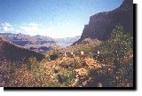
At Indian Gardens we sat on the picnic benches that surround a huge, old cottonwood, and enjoyed a leisurely lunch while being entertained, unintentionally, by one of the mule wranglers. He was leading a baggage train down into the canyon, and was apparently riding a young mule to get it broken in. At Indian Gardens his young mount decided he had had enough, and was going to take a break. There was quite a show for a while as the wrangler tried to impose his will on the mule. They ended up in a compromise, with the mule finally getting around to where the wrangler wanted him to be, but in his, (the mule's) own way. From the looks on the wrangler's face I believe that mule had better be careful or he will be dog food. Somehow, after lunch - with replenishing water, sight seeing around the Gardens and using the head - I got separated from the Huggins. Searching for them all around the area, and then waiting about 15 minutes for them to come up to the junction with the Plateau Point Trail, and not finding them, it occurred to me that they had gone on, so I started hobbling up the last 4.5 miles to the top. On my first hike to Phantom in 1987 this was the spot where I looked at the cliffs high overhead, and said to Bill, "There is no way that we are going to get out of here." "It sure doesn't look like it." he responded. "But," he continued, "the mules did it, so there must be a way." Bill and Nancy had been our here in 1985. He had taken the mule ride down to Plateau Point and back, and discovered "why cowboys walk so funny." So he had known that we would eventually get out, and he reassured me. Still, I was skeptical. And this day, with my throbbing knee, I was beginning to have doubts again.
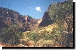
Wednesday, August 13, 1997: Hike out to Bright Angel Lodge.Looking back over my right shoulder to see the beginning of the Plateau Point Trail, I thought of the landings made here in 1921. R. V. Thomas, a World War I pilot, had made two landings on the relatively flat Tonto Plateau as a publicity stunt. The Point was known as Turtle Head in those days. Pretty risky, it seemed to me. He could have paid a high price for his publicity. But then, it was probably no more dangerous than Roger Dale's skiing down the North Kaibab Trail to the Supai Tunnel, and Roger wasn't being paid anything. He was just doing it because it was the fastest and easiest way to get down there. Shifting into my climbing mode, small steps slowly, I started trudging up the trail across the Tonto Platform to the base of the Redwall. A couple of hundred yards up the trail I passed the home of Brian Wisher, Park Medic who has been working with the backcountry medical services on the Grand Canyon since 1979, and is presently the head Ranger at Indian Gardens. Isolated as he is down here at Indian Gardens, it is nothing like the isolation that Bruce Aikens enjoys up at the head of Bright Angel Canyon. I wonder if Brian likes it as much. Probably so. Park Rangers are a breed apart. In addition to his other duties, Brian conducts educational tours for the Grand Canyon Field Institute, which tours can provide College Credit at the University of Northern Arizona and at Prescott College. Wisher is another of the dedicated and underpaid Park Rangers that most of us just take for granted. Our country is extremely lucky to have people like him in the Park system. A little farther on I passed the entrance to the Indian Gardens Campground, and finally made it out of the "suburbs" of the Gardens. Examining the cliffs ahead, the great Bright Angel Fault was perfectly obvious. At the head of the "V" in the canyon I could easily see the white Coconino Sandstone cliffs, and I could also easily see that at the peak of the V shaped canyon ahead the white line of cliffs to the right was dislodged higher that the cliffs to the left. As a matter of fact, the Coconino layer on the right is nearly 200 feet higher than the layer on the left.
If you sit on the porch of the North Rim Lodge, and look across the Canyon to the South Rim, this fault is even more obvious. From the vantage point of the North Rim it is also easy to identify another fault, far to the east. It appears that a several mile wide section of land has simply dropped down about 200 feet. It is these cracks in the hard rock layers of the Canyon that make it possible for animals and people to climb down through the massive cliffs of Coconino Sandstone, near the top, and the even more massive cliffs of the Redwall dolomite down near the bottom in order to get to the Tonto Platform. The Bright Angel Trail comes down the fault to Indian Gardens, and , I believe, the New Hance Trail comes down the eastern fault to the Tonto Platform far to the east. The way these trails have usually come about is that ancient Indians improved trails made by bighorn sheep, and then the early white settlers improved the old Indian Trails. Early water holes were discovered the same way. People followed animal trails, and found water. Colin Fletcher did that when he hiked the Esplanade in his famous "Walk Through Time." He followed burro trails to find water tanks. ("Tanks" are rocky depressions that hold water for relatively long periods of time after spring and summer rains. All Louie Lamour aficionados know that.) The trip up from Indian Gardens to the 3 Mile Rest House is probably the most difficult section of the hike out. The Devils Corkscrew up through the Vishnu Schist in the lower canyon is tough, but it is done in the cool of the early morning, when you are rested and fresh. You enter Jacobs Ladder, the steep switchbacks up through the Redwall to the 3 Mile Rest House, in the heat of the day, and when you are beginning to get tired. As Bob Ribokas says, it can be a killer. Fortunately, you loosen your muscles, and get warmed up by walking the easy slope of the Bright Angel Shale terrace. Leaving the life giving waters of Garden Creek, and the cool shade of the giant cottonwoods, you enter a semi-arid area characterized by desert- shrub plants like the blackbrush, and numerous cacti - plants that are adapted to living in dry, shallow and rocky soil. Along the way, not too far from the Redwall cliff I crossed the pipeline that conducts the water from Roaring Springs. The water gets all the way to Indian Gardens pretty much by the force of gravity, because Roaring Springs is at about the same elevation, but from the Gardens to the Rim it is pumped. Most of the visitors up on the rim have no idea that the water they are using comes from under the North Rim 15 miles away. By the time that I reached the base of the Redwall my joints had limbered up, and I was feeling pretty good. To my surprise, in spite of plodding along at my "snail pace," I caught up with Matthew and Bill at the Redwall base, where I took a brief rest because we had to step to the side of the trail to allow a couple of mule trains to pass. Bill cheerfully scolded a couple of the riders, because they didn't know the names of their mounts, and slapped his knees at others as he told them how funny they would walk at the end of the day. Some of them laughed with him. Others looked at us like we had just escaped from the funny farm.
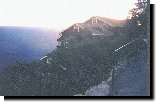
The Wranglers seemed to enjoy it. To my additional surprise, after a few switchbacks at my snail pace, I discovered that Matthew was far behind. He thought he was tired. He couldn't have been too tired: however, because now and then he would come shooting by me like a playful puppy. At the top of the Redwall I was unable to distinguish anything that I could identify as the newly classified Surprise Valley Formation. Being ready for a break, I didn't search too diligently for it. The 3 Mile Rest House was a mad house. It was crammed full, and overflowing with a wild assortment of hikers. People in street shoes. People in shorts. People in the most expensive athletic clothing you could imagine. People dressed like bums. Babies in back packs. Kids running around. Other babies crying. I liked it better down on the river. Since the Rest House was jam-packed, I found a shady spot outside, and sat down resting my back against a clay bank to take a brief nap. Bill and Matthew passed by. Well rested in a few minutes, I started out again, and once again overtook my buddies. This section of trail climbs up through the Supai, a group of layers of sandstone, shale and mudstone that were deposited in a swampy terrestrial environment. The Supai was laid down at the same time that the great coal bearing strata were being formed in swamps in other areas of our country. The pines and junipers that now grow in the upper reaches of the Supai are closely related to the trees that grew here hundreds of million years ago when the Supai muds were being deposited. Fascinating. A half mile below the Mile and a Half Rest House I came to 2 mile corner. This time, for the first time, I was able to spot the pictographs that had been painted on the rock high above the trail by Indians long ago. Having seen this type of art back in Marble Canyon when we had stopped above Stantons Cave, I was better trained at what to look for. I think that's the reason I was able to see it this time. Very satisfying. A half mile farther up the trail I was jarred by the grotesque creamy-yellow structure that has been erected on the steep slope to the west of the Mile and Half Rest House. It stands out like a wart on a nose. It has the charm of a chemical toilet, which is what it is. It could not have been designed to stand out more glaringly in the afternoon sun. From "Trailview," the overlook up on the rim, it is the most obvious as well as the most ugly building in sight. The Park service which fought Emery Kolb for years, trying to get rid of his "unsightly" studio, apparently has no concern about how a building blends in with the environment when it has the responsibility of designing, building and paying for it. The area near the top of the Supai, and under the north facing Coconino Sandstone cliff, where the Mile and a Half Resr House sits, is cooler that the rest of this part of the Canyon, because it has a little more shade, and therefore holds moisture a little more efficiently. As a result there is a stand of Douglas-fir and Gambel oak here. It is one of the few areas on the South Rim where these trees can be found. The book told me that I was now just 250 million years from the top. That's about how long I thought it would take me to get there. Bill agreed. At the Rest House a young couple from the Netherlands came up, and entered into a conversation with us. I had been passing, and being passed by them ever since I had left Indian Gardens, and we were beginning to feel like old friends. They told us that they had been in the US for 5 weeks, and were traveling around the country in a van in which they often slept. They had arrived at the canyon a couple of days before, had never heard of Phantom Ranch until they got to the Visitors Center, and on a lark had gone to the Backcountry Office to see if there might be a possibility that they could get a reservation. As it happened, a cancellation had just come in, so they hiked down to spend a couple of nights. Talk about luck! Around the Rest House I had picked up 2 bottle caps that had been discarded, so I was almost in a rage when a couple of hundred yards up the trail I picked up a cigarette butt. Smokers are the most inconsiderate people in the world! I used to be one, so I know what I'm talking about. After I calmed down, I had to admit that with all the thousands of people that use this popular section of the trail 2 bottle caps and 1 cigarette butt is not very much trash. The switchbacks of the section that the wranglers call "the Cinch-up" became progressively shorter as we ascended the fault in the Coconino layer, and it became even more obvious that the cliffs on the west were much higher, (189 feet to be exact) than the ones on the east. Also, it was easy to see the fresh repairs that had been made in the central parts of this cleft where the heavy flood of March of 1995 had washed the trail out completely. That must have been an impressive sight. I wonder what the Wishers were doing during that washout. Finally we passed through the Second Tunnel which brought us to the top of the Coconino layer. Several hundred yards above and to the west of the Tunnel we came to Kolb Seep and some more Douglas-Fir, where we switcbacked west to climb up out of the Toroweap layer and into the Kaibab Limestone. That was the last one. One more layer to go! One last major switchback brought us around to the east. The 1st Tunnel was in sight. Following a couple of squirrels that were having an intensive argument about something, I was pleasantly distracted until I reached the Tunnel. There I took a break, reloaded my camera and took some pictures. I had again lost Bill and Matthew. The rest of the hike was very easy. Knowing that I was almost at the top was amazingly refreshing. Suddenly Kolb Studio was right in front of me. To my shock the trail was blocked. No longer can you hike out of the canyon right up past the Studio. You are routed out to the west, the way that the mules go, and where they empty their bladders at the end of a long day. You get the idea.
Bill's explanation as to why the section of the trail that lets you walk up past Kolb Studios to the Bright Angle Lodge is blocked off is simple. He says, "Some bureaucrats noticed that people were having too much fun, so they put a stop to it." Returning to the switchback that lies almost at the top of the trail, the one that has all the signs warning hikers of the dangers of heat, fatigue, how it is harder to hike up than down, & etc. I rested and waited for Bill and Matthew. In a short time the Netherlands couple came up, and stopped for a chat. Among other things that they told me was that the previous evening, after sundown, they had seen a black bear in the Colorado at the mouth of Bright Angel Creek. They described how it had made a slapping sound. Proudly telling me that the ranger had told them that in the 10 years he had been down there he had seen a couple of bears in the western part of the Canyon, but had seen only one in the east., they were quite pleased at their good fortune. They also mentioned that the ranger had taken them out that night to show them scorpions. They described how the ranger had taken a "black light," (ultraviolet light) and shined it all around, illuminating the scorpions. (Scorpions glow visibly in ultraviolet light. That's how people in the business catch them.) Both were amazed at how many there were.
When Bill arrived on the scene, and they told him about the bear, he immediately grinned and said, "What kind of beer did you drink down there? I'd like to try some." The Netherlanders took it gracefully, and laughed with us. After taking pictures of them with their cameras we said good-bye to each other, and went our separate ways While Matthew napped Bill and I repaired to the bar at the Bright Angel Lodge to enjoy our reward. Premier beer. In the bar we concluded that the Netherlanders had probably seen a beaver. While we were relaxing, waiting for 4:00 o'clock to roll around, so that we could go pick up our baggage at the mule barn somebody slapped me on the back. Looking back, I immediately noted that I had to look up because it was 6 foot 6 or so Pete Smith, and his equally tall son coming in to join us. Tim Chizak was with them. Not only did we have a happy conversation with them, but Pete insisted that they bring our bags back from the mule barn when they went to retrieve theirs. After they returned, we shot the breeze some more, and exchanged addresses. As of this writing, (on September 4, 1997) I have been in contact with Pete a couple of times already. What a wonderful group of people we met on this trip. That was half the fun, and more than half the value.
Bob Groves 09/04/97 |
|
|
|---|
|
|---|