|
"The Canyon Trip Promised to Matthew Huggins" |
|---|
|
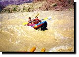
Saturday, August 9, 1997: Peggy and I were married 44 years ago today!Having camped below Shinumo Wash at the beach created by the Fence Fault we were only a little over a mile upstream from Stantons Cave. Stantons Cave was named for Robert Brewster Stanton, the chief engineer of the Denver, Colorado Canyon, and Pacific Railroad Company, a new company created by Frank Mason Brown. On the initial survey expedition Brown took 14 men down the Colorado from Green River, UT to outline a route for a rail line he planned to run from Denver to the coal fields in the deserts of the Arizona territory. His plan was to eventually supply coal to Los Angels. In order to make the survey more cost effective he decided that life vests were not needed. He may have saved some money, but at a very high price. It cost him his life. The boat that he was rowing with Harry McDonald steering flipped in a whirl pool just below Salt Water Wash a little over half a mile downstream from Soap Creek Rapids, and without a life preserver, Brown helplessly drowned. Peter Hansbrough, one of the members of the expedition, memorialized Brown with an inscription on the east wall of the canyon, "F. M. Brown, Pres. D, CC & PR was drowned July 10, 1889 opposite this point." Brown's cost effective decision continued to plague the remaining men. At 25 Mile Rapid, a couple of days later, Hansbrough's boat collided with an overhanging cliff, capsized, and he and cook's helper, Harry Richards, drowned. On another expedition 3 months later, Stanton found Hansbrough's body , identified by his clothes, at a horseshoe bend in the river almost 20 miles downstream from where these men had drowned. In honor of his friend Stanton named the point opposite where the body was found Point Hansbrough. The deaths of Brown, Hansbrough and Richards was a little discouraging to the remaining men. I suspect that the lack of life preservers weighed heavily on their minds. Stanton decided to temporarily discontinue the rest of the survey. He found a good sized dry cave well above high water where he cached the boats and some of their gear, (a revolver, some photographic equipment, tobacco, rice, flour, sugar, baking powder and some other stuff). In addition to the cave in this area there was an Indian trail leading up an adjacent side canyon, so he and the rest of the men could hike out and make their way back to Lees Ferry. There are a lot of old Indian ruins around this area, and the cave held evidence of Indians having used it for something even though there is no evidence that they ever actually lived in it. Bus Hatch discovered the first of the famous split twig figurines in the back of this 140 foot deep cave in 1934, and in 1963 Robert Euler, who was appointed by the National Park Service as Park Anthropologist, recovered about 165 of them. They have been dated to 4,000 years ago. Although all of these artifacts have been removed, the Park service has barred entrance to the cave with an impressive Iron gate, cross hatched in such a way as to keep vandals out while allowing the bats that live there to fly in. During our trips from 1988 until the present, Bill and I have seen that the Park Service has built more and more sturdy gates. Apparently signs, and simple bars have not been adequate to discourage dedicated vandals. The reason for keeping people out is that beneath the soil of the cave there is a lot of archeological information, - remains of ancient horses, Harrington mountain goats (from 20,000 years ago), Humpback Chub fish, California condors, and an extinct vulture that was even larger than a condor - and a lot of other items of scientific interest. Anyhow, that area which was almost in sight of our camp was to be our first stop for the day. Before we set out Jack, a Park Ranger who accompanied us for the first few days of our trip, and Nichol Corbo, the pretty assistant cook and oarsman - who was a big help to me on some of the tougher side hikes, especially up the Eminence Trail opposite Point Hansbrough, pumped up the inflatable Kayak. Jack was born and raised in Bangor Maine, was a school teacher for a while, and has spent some time as a Ranger in Brunswick, GA. He now is in charge of the entire western part of the Grand Canyon Park. That's a terrific responsibility that requires skills in administration, diplomacy and law enforcement in addition to those of a boat repairman and engine mechanic. Jack didn't tell me this, but after a few conversations with him it became obvious to me that these characteristics are demanded by his job, and it also became obvious to me that he is pretty darned good at it. I'd like to add here that Bill and I have had nothing but good experiences with Park Rangers. There may be some bad ones out there, but in all the years that we have been visiting and using this nations parks we haven't seen them. Jack says he spends as much time getting peoples boats running again as anything else that he does. Tim Chizak, a graduate of Rutgers - now a CPA in Manhattan, and Don Streetman, a member of the California contingent, were the first brave souls to try out the kayak. They did a good job, shooting around the river like a couple of pros. Soon we were all debarking on the beach a quarter of a mile or so up from Stantons Cave. Thinking that we didn't have much time I didn't change from my slick-soled booties, and once again turned an easy climb up to the top of the talus into a sliding scramble, but I made it. Factor gave us an interesting discussion about the ancient people that had lived in this part of the canyon around 750 to 1,150 A. D.. (I know, I know. That's no longer politically correct. I should say "after the common era." But I'm too set in my ways to change, so put up with me.) He also pointed out some of the many pictographs in the area. Next Rhonda Barbieri, soon to be from Seattle, WA, and who has her degree in Herbology from USC, gave us a lot of information about the flora and fauna of the area. She is very knowledgeable about how and what the ancient canyon dwellers did with the various plants. Can you imagine soap, cord, sandals, medicine and insect repellent, not to mention food, all from Utah Junipers? Fantastic. These folks also had aloe vera, which we use today because of its natural healing properties due to the steroid content of the juice of its fat leaves. Some people are surprised that this plant produces a cortisone-like chemical. These same people are also surprised to learn that the first birth control pills were developed from the hormones of Mexican yams, and that the blooms of African Violets are greatly enhanced by adding birth control pills to their water. As we started our return trip back down to the boats I asked Factor what he thought about the possibility that the Anasazi or other early Indians used some sort of water craft. I'm pleased to note that his thinking is very much like mine on this subject. Remarking that there are a lot of regions in the canyon showing evidence of human presence on both sides of the river during the same periods of archeological time, and pointing out that in many of these areas there is an access trail on one side of the canyon, but not on the other, it is logical to think that these ancient people used some means to cross the river. My feeling is that they may have constructed rafts by tying logs together with the stout cords that we know they fabricated. Factor, on the other hand, believes that they probably used dug-out canoes. Who knows? They may have used both. What I do not believe, and find unacceptable, is the often stated idea that these people never used water craft. There is so much evidence of their skill and ingenuity, that to assume that they never fabricated water craft is, in my opinion, scientific blindness. A small bat was spotted in a crack in the rocky slope that we descended to the boats. I tried to get a picture of it, but the gray bat blends into the gray rocks, and is invisible on the film. Right downstream from the beach in front of Stantons Cave is a green and sparkling area created by several springs gushing out of the canyon wall. Powell's description of it is that here, "The river turns sharply to the east and seems enclosed by a wall set with a million brilliant gems. . . . .rocks below the fountain are covered with mosses and ferns and many beautiful flowering plants. We name it Vasey.s paradise, in honor of the botanist who traveled with us last year." The major may have exaggerated some, but not much. After all he had been on the desert river, and on it a time when there were no tamarisk trees or any of the greenery made possible along the banks by the controlling presence of Glenn Canyon Dam. He may have been struck by the contrast much more that are we latter day casual travelers. We snapped some pictures of this Paradise as we drifted by, then the heavens clouded up, and it began to rain a soft, intermittent rain. By 10:30 we were a mile below Vasey's Paradise, and rowing gently in to the beach at Redwall Cavern. Erosion over eons of time has deeply undercut the rock in the bend in the river here creating a cavern that I measured to be 250 feet deep and 500 feet wide. If it was shaped a little differently you could almost fit a football field in it. It is huge, but not quite as impressive as Powell remembered it when he wrote of his canyon explorations some 20 years after his trip. This structure brought out some of Powell's tallest tales. He wrote that it was, ". . . a vast half-circular chamber, which, if utilized for a theater, would give sitting to 50,000 people." Pigmies maybe, but even that is doubtful. Certainly not us. Someone produced a light plastic bat and a light, plastic ball. Naturally a soft ball game broke out. Matthew is big on baseball, his favorite sport, so he was delighted. We had the place to ourselves for 20 minutes, and even when an oar powered group from Mad River Cruises pulled in our game continued with enthusiasm. Not long after a big, motor powered ,(ugh) 18 passenger Wilderness River Adventures raft, sedately nosed in (looking not unlike the Queen Mary in a yacht basin) we reluctantly gave up the area to superior numbers, and went on our way. Our next break was a lunch stop at Nautiloid Canyon 2 miles down from Redwall Cavern. I was surprised to learn from Nancy Brian's book, "River to Rim," that the United States Board on Geographic Names, (BGN) has not yet officially approved the name of Nautiloid Canyon. That seems a little strange, especially since the name Indian Dick was approved by the BGN in 1955. Do phallic symbols grab the attention of bureaucrats more than ancient cephalopods related to squids? There is a steep, rocky climb up to the floor of the grotto where the fossil remains of these water animals can be seen. Having previously been up there, and having taken pictures of the creatures on my earlier visit, I was not strongly motivated to make the climb. My right knee that I had sprained in my stair climbing conditioning was stiff and sore, and I could not completely flex it, so I decided to skip this particular hike. Clyde Philbrick, the 78 year old post pentuple bypass patriarch of 8 of the 16 of us on this trip remained with me down with the boats. When his kids called down to see if he was coming up to join them at the top of the cliff his response was, "Discretion is the better part of valor." Let me mention here that Clyde is a veteran of flying the "Hump" from India into China during World War II, has owned and operated an aircraft business, and has had a fascinating life flying all over the world. He's got valor to spare. Discrete. That was the word. That's what I'd tell the folks back home. Bill and Matthew made the climb, had a good time, and got some excellent shots. One other thing that I am strongly motivated to bring to the attention of all of you readers out there is the fact that when the two Lehigh men had their turn a paddling the Kayak this day they capsized. It was obvious to all who viewed this disaster that this father and son team set some sort of record, (that should be submitted to the Guinness people) in getting back into the kayak. No doubt the temperature of the water had something to do with it. Those of us that happened to blink at the time missed it. They were that fast. After a pleasant rest and lunch at the Nautiloid Canyon beach we set out again down river through the intermittent rain showers that were becoming more and more frequent, and more and more heavy. It was getting cooler, and time to get out the foul weather gear. The Patagonia pile jacket and pants that Peggy had given me many years ago to use while sailing during the winter months was a life saver to me. During the afternoon we rowed past the old Marble Canyon Dam site, where the test holes in the rock on either side of the canyon are still visible. Back in 1966 David Brower, the Executive Director of the Sierra Club responded to the argument of the Bureau of Reclamation that creating lakes in the Marble Canyon and in the western Grand Canyon would improve public access by boat. Brower's response was a series of adds that were run nationwide saying, "Should we also flood the Sistine Chapel so tourists can get closer to the ceiling?" The heavy handed bureaucrats did themselves in when they retaliated by taking away the tax exempt status of the Sierra Club. That was the undoing of any public support for the dams, and in 1967 Congress, responding to overwhelming public pressure, placed a moratorium on the Federal Power Commission's right not only to sanction dams in the Grand Canyon, but also a moratorium on even studies for dams in the Grand Canyon. As the afternoon progressed Matthew spent a lot of time in the kayak with Scott Smith, and they shot through some pretty significant rapids. Meanwhile dirty water began flooding in from side canyons as the rains increased, and the Colorado began to take on the red hue of the old pre-dam days, the color that had given it the Spanish name - Colorado.
Factor provided us with one more stop for the day at Berts Canyon, another canyon well known to river runners, but whose name has not yet been made official by the BGN. The canyon is named for Albert (Bert) Loper, one of the first canyon rivermen. He first attempted to run the canyon in 1907 at the age of 38, when he started at Green River, UT with Edwin R. Monett and Charles S. Russel. Loper's boat was damaged in Cataract Canyon. By the time he repaired it, and rowed on down to Lees Ferry, the other two had gone on without him. He successfully made it through the entire Grand Canyon in 1939 at the age of 70, and by that time he had became sort of a legendary boatman. His last attempt was in July, 1949. An apparent heart attack did him in at 24.5 Mile Rapid. He was essentially 80 years old. His boat drifted on down until it became lodged on a rock at the upstream side of what is now known as Berts Canyon. Bert's friends dragged his boat up well above the flood line, and painted the message on the bow, "Bert Loper, Grand Old Man of the Colorado, Born: July 31, 1869. Died: July 8, 1949."
We sat around the remains of Bert's boat while Factor told us the history. The next thing I knew as we got on the river again was that I was in the rear seat of the kayak with Bill up front. With my hearing aid out to keep it from getting waterlogged, and Bill shouting and signaling instructions to me, instructions that he was hearing from Factor, and my misunderstanding half of them, we made quite a pair. However, our previous experience canoeing on the Georgia rivers gave us a head start, and after a few strokes we were handling the thing very well. A few rough patches of water gave us the feel of how to handle it to stay upright, and suddenly Factor was getting real serious as he told us what to do. We were approaching President Harding Rapids. This rapids used to be known as Boulder Rapids, named for a boulder, (that looks as big as a small house) in the center of it, and early rivermen soon discovered that almost the entire force of the current here tends to drive you to it. The rapids is rated a paltry 4, because if it is done correctly you get through the 4 foot drop with no problem, but if you make a mistake it can be disastrous. The left side of the boulder is impassable. Too many rocks that would tear your boat apart. On the right side of the rapids there is a continuous wave, known as a lateral, that funnels the water directly toward the big boulder, and this creates a huge spiraling wave all around the boulder. Claude H. Birdsey was leading a surveying expedition through the canyon in 1923 when they heard of President Warren G. Harding's death. They were at Soap Creek Rapids on August 2, when they heard the news. The radio broadcast said that August 10 was going to be set aside as a Memorial Day for Harding. The Birdseye Expedition got down as far as Boulder Rapids on August 9. They camped there, and rested the following day. On that Memorial Day the expedition honored the president by naming the rapids for him. Last year a private raft trip lost nearly all of its supplies when the trip leader was thrown out as his raft flipped in this huge wave. Since he was only going a short distance that day, and since President Harding was only a 4, he had not secured his equipment or supplies, including most of the food, to the raft. He lost it all. Our guides were chuckling about it, telling us how hungry those people must have been before they could get down and out of the canyon. Bill and I were able to execute Factor's instructions almost perfectly. We aimed the kayak directly toward the right bank, and paddled just about as hard as we could in order to keep the bow within 10 feet or so of the bank. This maneuver had us traveling at right angles to the downstream flow. At the very last minute, just as we hit the lateral we swung the kayak around to the left, (port for all you wise guys who love nautical terms) 90 degrees, in order to enter the lateral at right angles to it, straight on, and not sideways - which would be a catastrophe. Our maneuver was perfect. In spite of almost disappearing in the deep hole immediately beyond the lateral, and being swamped by the oncoming wave beyond the hole, (which wave looked as high as a house wall from down there in that little kayak) we came up for air right side up, and in control. It was amazing to me how close the current had swept us to that boulder, when we had started out almost at the river bank. After all of this we almost capsized on what appeared to be an almost perfectly flat section of water. We had come up out of all of that turbulence to find ourselves up on what appeared to be a plateau of swirling water. We seemed to be a foot or so above river level, but on flat water. It was weird. I called out to Bill that things were not right, and they surely weren't. Something suddenly grabbed the kayak, and nearly flipped us, but we were both prepared, and with judicious use of the paddles as well as leaning appropriately as the situation called for it we were able to remain upright until we shot off of this plateau, and back onto the normal river flow. Whew! Quite naturally we felt called upon to point out to the Lehigh men that Lafayette had made it safely through President Harding Rapids, while Lehigh had flipped in a less famous part of the river. Camp was directly across the river from Point Hansbrough. Supper, though it was another delicious dinner by Dennise, was not anything like as interesting as that kayak ride. I really needed, and enjoyed our snake preventative that evening. Remember from last year? We still haven't seen a snake. Recipe for snake preventative: One shot Beef Eaters One cup Gator Aid, Sprite or whatever. Sip slowly. Works every time. By the way, it is not necessary for Matthew to ingest the snake preventative. All he has to do is not to leave the camp. Bill and I keep the snakes away from everyone in camp. |
|
|
|---|
|
|---|