|
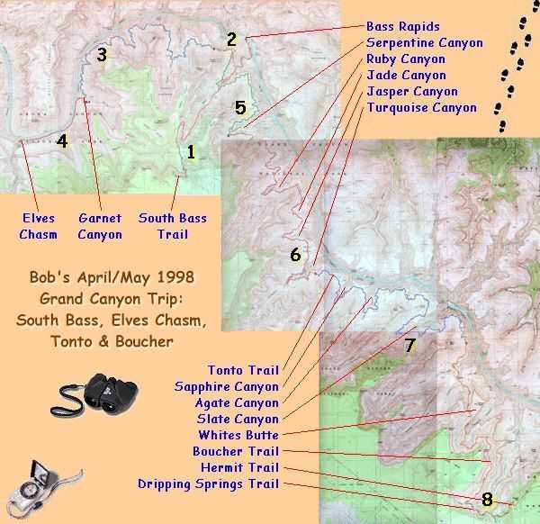
Trip Report - April/May, 1998 - South Bass, Elves Chasm, Tonto, Boucher |
|---|
This was a wonderful trip, a little on the warm side at times, but for the most part the temperature was very comfortable. There were frequently lots of clouds in the sky, especially in the afternoons, which also made it very nice for hiking. I would frequently see it raining in other parts of the Canyon and would hope that it would come my way but it almost never did. I did get hit by the occasional sprinkle, mostly on the first day, but the total amount of rain that fell on me during this entire trip would not even come close to filling a film canister. I tended to start my hikes very early and after the first couple of days even gave up on having breakfast before breaking camp to get an even earlier start. I would get up at first light and be on the trail as soon as there was enough light to see by and then stop for breakfast as the sun was cresting the rim. The mornings were simply glorious and when the sun came up there was usually not a cloud in the sky. I would then hike until around noon and then find a shady niche to hide in for a couple of hours to eat lunch and rest for a bit. I would normally start hiking again between 1:30 and 2:00 and then until... whenever I decided to camp. The nights were wonderful and I only put the rain-fly on a couple of times because it clouded up late in the day. Usually the clouds would clear out within a few hours of sunset and the stars would come out in all of their glory. The moon was just after its New phase, setting shortly after the sun, and apart from the last couple of days it was never to be seen. This made for an exceptionally dark sky and the stars were magnificent. I cannot remember even seeing the Milky Way so bright. I wished that I could have afforded the weight to pack in a telescope on this trip. I almost decided against taking my sleeping bag at the last minute to save on some weight but the mornings were cool and I was glad to have it to crawl into.
Water was, for the most part, my biggest concern and luckily everything worked out in this area as well. The spring rains had water flowing in most of the major side canyons although some of this stuff tasted pretty nasty and it never really quenched my thirst. There were a few tough moments that had me wondering but I always had a reserve of 2-liters just in case, and even that made it back to the rim. I hate carrying the 4 extra pounds when you end up not using it but when you're in the backcountry and don't know for sure where your next drink is coming from it is a real comfort to know that it could come from your backpack.
The western Tonto between South Bass and Boucher was much easier to follow than I expected. I have heard this section of the Tonto frequently referred to as a "no mans land" but I did not find this to be the case and the trail was very obvious and well cairned in "most" places. Oddly enough, this was the only section of trail in which I did not encounter any other people and I had the whole stretch to myself for the two days that it took to cross it.
The western Tonto from South Bass to Garnet was a completely different story. I frequently would run out of trail in this section and would have to retrace my steps to find it again. A couple of times I encountered other hikers who were also on "the trail" even though it was no where near "the trail" that I was on. The trail along this section is very faint in places and very difficult to discern from the rest of the landscape. There are cairns but, for the most part, they are very small and very far between. Sometimes I would notice that I was off the trail and just try looking around for the cairns in other places but they would frequently end up being a bush or something and would take a while to find. On a couple of occasions I would simply have to guess where the real trail was and head off in that direction. I guess my route finding abilities are OK because this always worked, or at least it got me to another copy of "the trail".
Happy Trails
|
|
|
|
|
|---|
|
|---|