|
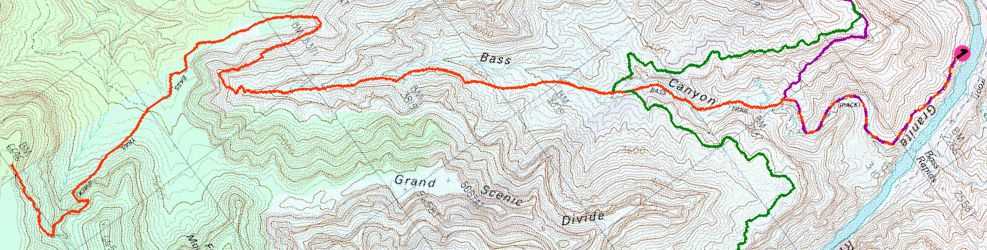
Day 1 - South Bass trailhead to Bass Rapid |
|---|
|
|
|
|
I left Boston at 4 pm the day before, arrived in Phoenix at 9 pm and was at the Canyon at 1 am. After some shuffling of gear, I was in bed around at 1:30 and got little or no sleep at all - my body was just too worked up and by the time I got to sleep it was already 4:30 am at home and almost time to get up. When I received my 6 am wake-up call I nearly died, this was not a good way to be starting a nine day hiking trip in the Canyon.
After a long shower I headed over to the Bright Angel Lodge for a big breakfast with LOTS of coffee. After that and a few minutes standing on the rim and gazing into the abyss I felt much better and almost human again. It was then that I noticed the ominous looking dark clouds hanging over the western regions of the Canyon. It appeared to be raining at some locations out there and my body shuddered and I heard myself mumble "Oh, no, not again". The last time I tried to do this trip Arizona got whacked with two hurricanes back to back. Hurricanes in Arizona... I still can't believe it. Anyway, I returned to my room and called Ranger Marty, my ride to the South Bass trailhead, to see what he had to say. Luckily, the apparent bad weather in the western regions did not concern him and he did not appear to have any intention on backing out on the ride. I kept my fingers crossed. There had, after all, been no forecast of major rain for the area and one forecast only predicted some isolated afternoon showers. The weather was nice over the village and it was sunny with some fluffy white clouds. All I needed was to get to the trailhead. Marty and I agreed to meet at 8:30 at the parking lot near the Bright Angel trailhead. I would leave my rental car there and would take the shuttle bus back to it when I hiked out on the Hermit Trail, nine days later. He said that there had been a mix-up with the camping gas that I needed for my stove and I would have to go over to Babbitt's and pick it up myself. I did that, checked out of the room and headed over to the arranged meeting place. Marty was there right on queue and after some quick introductions I tossed my gear into the back of his full-size NPS pick-up, and away we went. The road out to Pasture Wash and the South Bass trailhead was the worst road that I have ever seen. The ride was nothing less than two hours of being tossed about by this rock-strewn, deeply-rutted, sorry excuse for a road. There is probably nothing that would ever make me want to drive this road myself and I was very thankful for the ride out to the trailhead. It pays to know people who work for the Park Service and to do favors for them. The weather turned more gloomy as we traveled further and further west and we were hit with a couple of small showers during the ride out. I offered to let Marty leave me off at Pasture Wash and I would have walked the last few miles to the trailhead but he took me all the way. We arrived at the trailhead for the South Bass Trail at 10:30. Marty lingered a while and checked on some of the other vehicles that were parked out at the trailhead (all 4WDs and heavy duty pick-ups) and I took some pictures from the rim before starting down. I felt bad that he had to do that drive all over again to get back to the village. And then he still had a 14-mile hike himself, to get back to his workplace, at Cottonwood Campground on the North Kaibab Trail. Well, I was here at least, and the weather, right now at least, was perfect hiking weather, partly-cloudy (about 50-50) and very cool. I took off my sweatshirt in spite of the coolness as I knew that I would very soon be generating a great deal of heat of my own. I set off down the trail. The trail dropped very moderately at first and was very nice but very quickly became more steep and rocky. It headed east for a while and then around 10:45 I hit the first set of switchbacks. I kept looking for the ruin of an Anasazi granary that was supposed to be near the top section of the trail but I never found it. I continued down at fairly good pace, through the Kaibab, Toroweap and Coconino formations. At around 11:20 I was starting into the Hermit Shale and by 11:40 I was through that as well and the trail broke out on to the Esplanade. The views from this section of the trail were awesome, with Mount Huethawali looming ahead of me, the south rim to my back, the Grand Scenic Divide to the east and Garnet Canyon and the Darwin Plateau to the west. The sky was much darker now and there was very little blue sky overhead. I was hit by a few sprinkles during descent and one or two more as I headed north across the Esplanade. I passed the junction of the Royal Arch Route at 11:45 and wondered if I would ever get up enough nerve to attempt that. The trail across the Esplanade was nice and very easy to follow. The Esplanade is covered with cryptobiotic soil, which the trail slices right through, so it's important not to wander off of the trail here. This soil is very fragile and if damaged by a footstep can take a hundred years or more to recover. As I approached the location where the trail should be starting down into Bass Canyon, I noticed a spur trail of sorts heading off to the east. The main trail obviously continued north so I don't know what this was and did not want to take the time to investigate. The main trail started to climb briefly and then sort of dead-ended at an apparent campsite. I started wondering if I was supposed to take the other trail and then noticed a place further north where the main trail continued and finally began its descent into the west side of Bass Canyon. The trail down was very steep, very rocky and also covered with loose, slippery soil. It was not fun. At 12:30 I reached the point where the trail turns back towards the south and began the descent to the head of Bass Canyon. The clouds were now starting to break up and there was lots of sun and it looked like a perfect place for a lunch break. Lunch consisted of Summer Sausage, a couple of tortillas and some Chex Snack Mix. By the time I hit the trail again at 1:00 most of the clouds were gone and the sky was mostly blue. It took about 30 minutes to work my way back to the head of Bass Canyon. The trail through this section was mostly good with a couple of steep spots with some loose rock. At 1:30 I reached the head of Bass Canyon and started down through the Redwall break. It took another 30 minutes of negotiating switchbacks to get to the floor of Bass Canyon, arriving there around 2:00. Towards the bottom of this descent I began hearing the occasional voice behind and above me and knew that someone else was headed down the trail. I rested beneath some Redbud trees that were blooming on the canyon floor. After a few minutes the other party showed up and we talked for a bit. They were a group of four guys who were kayaking through the Canyon and had left their kayaks near Bass Rapids and gone up the South Bass Trail on a day hike. I don't know where they were as I should have passed them at some point when I was coming down the trail. I suspect that they may have been off on the Royal Arch Route somewhere when I passed through that area. At 2:15 I started heading down Bass Canyon. There did not appear to be a trail and I assumed that at this point I was just supposed to follow the canyon. Following the canyon floor proved to be impossible and I eventually gave up and started looking for a trail. I eventually found it on the east side of the drainage. The trail stays out of the drainage for the most part and a good distance above it and for a while there I was becoming concerned that I had missed something and had somehow ended up on the Tonto Trail heading east. Checking the topo confirmed that I could not possible have reached the trail junction with the Tonto yet so I continued on. At 3:15 I encountered some other people coming up the trail. This was an older man and younger woman who had been in the Canyon for while and had come from the Boucher area. They were headed up to the south rim to meet someone who was supposed to re-supply them and they were then going to come back down and head over to the Garnet area for a while. They gave me a report on the water conditions along the Tonto Trail and said that all of the side canyons along the way had lots of water in them. We said our good-byes and thought we would probably meet again somewhere over near Garnet. I was very pleased with the report at the time but it would be many days before I would discover that "all of the side canyons" and "lots of water" were obviously terms that mean different things to different people. Either that, or many of the side canyons had dried up in the week since they had passed through them. At 3:25 I reached the junction with the Tonto Trail heading west, the trail that I would be coming back into Bass Canyon on in four more days. About 5 minutes later I reached the junction with the Tonto Trail heading east and dumped my pack to look for a good place to cache some water. I found what appeared to be a good spot between two large boulders, slipped in a two liter bottle of water, and packed some loose rocks around it. For future reference, if you have paper and pen with you, it's probably a good idea to draw yourself a map or make a quick sketch of the area, if you are going to be gone for several days and hope to be able to find your cache again. Sometimes a place that seems like a really obvious cache site doesn't look that obvious when you come back to it. At 3:40 I continued the hike down Bass Canyon and it felt good to all of a sudden have four less pounds in the backpack. I had almost consumed about 2 more liters of water so the pack was actually about 8 pounds lighter since I left the rim. The lower section of the South Bass Trail crisscrosses the canyon about 4-5 times in the distance remaining to the river and ends up on the west side just before you reach it. It was pretty easy to follow but sometimes it remained in the creek bed for a while and sometimes it would cross over to the other side and sometimes would come out on the same side that it went in. You definitely need to pay attention to it. I stopped for another rest along the way and one of my feet was feeling a bit funny so I took the boots off to check my moleskin. It looked all right so I just decided to keep the boots off for a while and take a rest. I also got out the Summer Sausage and Chex Mix and had a little snack. After about a 15 minute rest I put the boots back on and continued on down the canyon. When the trail does finally come out at the river you are still a couple of hundred feet above it. Continuing west for another 1/4 mile or so will bring you to a large cairn which marks the descent to the beach above the rapids. If you continue west you will come out to another beach below the rapids. I headed down the descent to the beach above the rapids and was passed by some people from a river trip who had gone to the lower beach to scout it out. The descent was very steep in places and required lots of boulder hoping. I passed by the "Ross Wheeler" on the way down and some very fond memories of my own river trip, almost a year ago, come flooding back. I can still remember sitting beside that old boat, with the rest of the party, as we listened to Chris read us the history of the boat. I lucked out when I got to the beach and was all of a sudden back on a river trip. The party that was there was a NPS GRCA river trip and they would be camping there for the night with me. They apologized for disrupting my peace and quiet and claimed that they had planned on camping at the lower beach but that another river party had beat them to it. I explained to them that I had been on a river trip once myself, was aware of the routine and knew that it was all part of life on the river. I ended up finding a nice out-of-the-way campsite anyway and it was not really a problem. It would be nice to have a river party to share the first night with and I knew there would be plenty of other opportunity for solitude on this trip. After I setup camp and made myself some dinner I went back to visit with them. They offered to feed me but I wanted to eat what I had rather than carry it. Besides, the plan was to finish off the Summer Sausage, that I had been eating all day, for dinner and that would not keep if I did not eat it. I did NOT refuse the beer when that offer came. Dinner consisted of Lipton Noodles & Sauce, beef flavor with some chopped up Summer Sausage mixed in. I knew it wasn't nearly as good as what the river trip was eating but it was still good. After dinner I headed over to chat with the river party. I learned that the original goal of the river trip was one of archaeology and they had been studying some new ruins that had recently been exposed in the [location deleted] area. They actually were very elusive about the location of the new site, and for good reason, and it wasn't until I got back to the rim and checked my "sources" that I was able to get more specifics. I'm sorry that I can't be more specific but unfortunately pot hunters surf the web too. Anyway, the original trip ended at Bright Angel Creek and some of the party hiked out from there. Some other NPS employees came down at that point to join the party and run the rest of the trip to Diamond Creek. They were a very friendly group of people and we had a nice night together. I had another beer with them and they also passed around a bottle of some Irish Whiskey. They also scrounged up some driftwood and burned some trash so we actually got to have a campfire. It was a great beginning for the trip and I slept exceptionally well on that first night. The stars were out in all their glory and they are the last thing I remember seeing before drifting off to sleep. |
|
|
|
|
|
|---|
|
|---|


