|
Day 2 - Bass Rapid to Tonto Platform |
|---|
|
|
|
|
|
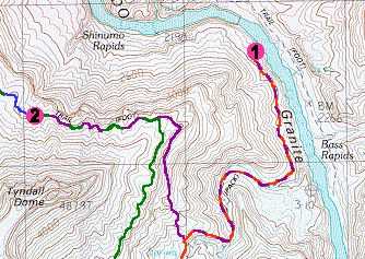
I woke up around 5 am but did not get up right away. I also woke up a couple of times throughout the night but all-in-all slept very well. The new air mattress that I bought is a LOT more comfortable than the old foam pad that I used to use. It weighs a little more but it takes up a lot less space. I dozed off and on until around 5:45 when I finally decided to get up. I didn't know how early the river trip would be departing and I wanted to use their heavy-duty water filter to top off my water bottles before they left.
For breakfast I made some Oatmeal and then went to mooch some coffee from the river trip. I didn't even have to ask for coffee and they offered it freely as soon as they saw me coming. What a great group of people! I remembered how nice and strong the coffee was on our river trip last year and was hoping for the same. I was not disappointed. I drank about 5 or 6 small cups of the stuff, maybe more, I lost count... good stuff. I had some instant coffee with me but nothing like this stuff. The river party also claimed to have some extra pancakes and they offered those to me as well. I gladly polished them off and they were very good as well. I was now about one full day into the trip and so far everything had been falling right into place. I didn't even develop any problems with my feet on the hike in and this morning I felt great. I hoped that would be a good sign and that things would remain that way for the rest of the trip. The river party was finally packed up and ready to leave around 8:30. I grabbed my camera and scrambled down among the boulders to find a good spot below the rapids to take some photos. The level of the river had dropped considerable during the night (well over a foot and probably close to 2 feet) and the rapids looked a lot more violent than they had the day before. Bass Rapid is not that big a rapid, however, and none of the rafts had even the slightest bit of trouble with it. I waved good-bye to the river trip as they headed off down-river. In a couple of hours they would be at Elves Chasm but that trip would take me two days. One of the guys from the river trip, a park ranger, was leaving the trip at Bass and hiking back to the rim. I met him as I was headed back to my campsite and talked with him for a while before he started his hike out. He asked for some info on the trail conditions and if he might find any water along the way and I told him that there had been some water in some of the potholes on the Esplanade the day before. After he left I was the only person left on the beach and all of a sudden it was very lonely. I didn't break camp right away as I was in absolutely no hurry today. All I had to do was a few miles, hike up Bass Canyon to the spur trail to Bass' Overhang Camp and the Tonto Trail west and then find a place to camp up on the Tonto Platform. Originally I had planned on two nights at Bass but if I could get out of Bass Canyon today it would make tomorrow's hike over to Garnet that much easier. There were a lot of clouds in the sky this morning but they did not look that threatening and there was also a lot of sun. I found a shady alcove in a spot set back from the beach, got out my book, read for a while and just watched the river go by. After about an hour I got up, broke down the tent and started packing things up. I was ready to go by a little after 10 am and didn't know what to do. A couple of dark clouds had drifted by in the past hour and I felt a couple of rain drops as they passed overhead. There was still lots of sun but if it was going to rain I wanted to be out of here before it started. I sat down, watched the river and the clouds and procrastinated over this for a while before I decided to head out. It was 10:45 when I finally decided to leave and by 11:05 I was up the spur trail back up at the cairn on the main trail and on my way out. It took about 45 minutes to get back to the location that I had decided the day before was the spur trail up to the Bass Overhang Camp. It was not much of a trail but there were some cairns and it seemed to be heading in the right direction. I lost the trail a couple of times on the way up and managed to find it again by scouting out the cairns. From the placement of the cairns it seemed to me that there may be more than one route. It did not take long to climb up the trail and by just after noon (12:10) I was at a nice, shady overhand, beneath a very (VERY) large rock. This overhang is on the north side of a large block, or pillar, of Tapeats sandstone that has separated from the main plateau, and is the same rock that had been visible from the creek bed. The overhang beneath it seemed to see lots of use. It was not huge but there was probably enough room for a few people to sleep and maybe even pitch a small tent. I didn't know for sure if this was "the" overhang but it seemed likely. There didn't seem to be much of anything else around and I was almost to the top of the Tonto. The last section of trail leading up to the overhang was very steep and had lots of loose rock on it, it would not be pleasant to descend with a heavy pack. The clouds had increased considerably since I left the river but there were still some gaps and some sunny breaks. There were a few pesky mosquitoes hanging around beneath the overhang which I had to eliminate. I decided that I would rest here for a good part of the afternoon and start off my having some lunch which consisted of Tuna, mayonnaise, tortillas and some Chex Mix. After that I read some more, checked my maps, watched the clouds play over the Canyon and took some photos. I hung out there until around 3 pm when I decided to head up to the Tonto Platform to look for a campsite. The climb remaining up to the Tonto junction was pretty gradual and very easy and I was there by 3:25. I very soon found an excellent spot to pitch my tent but some ferocious gusts of wind would not permit it. I could not get the pegs in the ground here either and tried using rocks to hold the pegs down. The wind was just too strong and after a while I gave up and set off in search of another site. This was not promising as the wind would simply not let up. I knew that I was very close to the boundary of the Bass / Garnet Use Areas and hoped it would be OK if I was a little over the boundary. After a few minutes of walking I came to the source of the wind, a huge open amphitheater below the Tonto and just downstream from Bass Canyon. It was quite an abyss and was almost a sheer drop down from the Tonto to a small plain that opened up on the south side of the river. As I headed past this the wind subsided considerably and I started looking for another site. At one point I thought I found one and left the trail to check it out. The ground was solid rock however and there were no loose rocks around that I could use to secure the tent. I gave up and headed back to the trail but could not find it. After some confusion and hunting around I slammed my walking stick down hard into the ground and to my surprise it didn't bounce pack but rather went in. I poked around a bit more and it seemed that I was on a patch of real soil. I said to myself, "Self, this looks like camp for the night" and proceeded to pitch the tent. I would worry about finding the trail again later. After pitching the tent I located the trail and looked at my topo map to figure out where I was. This section of the Tonto was very overgrown and difficult to follow and I hoped that I would be able to make it all the way to Garnet Canyon tomorrow. I already knew that the trip from Garnet back to the Ruby Use Area would be tough and hoped that I wouldn't be violating my permit on that night as well. I thought about cutting the day hike to Elves Chasm short so that I could get back to camp early, pack stuff up and start head back towards Ruby a day early. I decided that I would pay close attention to the route over to Garnet tomorrow and try to time how long it would take me to do it in reverse. Anyway, when I figured out where I was on the map I thought I was in trouble, and hoped that a ranger would not happen by. I appeared to be about a mile inside the Garnet Use Area and my permit was for Bass. The next day I would discover that I was wrong about this and had set my location incorrectly. I was still inside the Garnet Use Area but it was only by 1/4 mile or so and very close to the boundary. I don't like breaking the Use Area restrictions because I understand why the policy is in place. Given the fact that I was so close to the boundary though I felt that it would be OK. I headed up to some small cliffs of Bright Angel Shale just above my campsite to sit down in some shade and wait out the afternoon. I had an excellent view through a gap in the plateau clear down to the river. I could see some rafts from a river party near a small beached that looked like it could be Shinumo Creek. The clouds were breaking up again and there was lots of blue sky. There was a small storm over on the north rim and I got to see a rainbow form over the Dox Castle on the other side of the river. The dark clouds eventually came over to the south side but did not drop any rain on me. At around 5:30 I started making dinner. Tonight's entree would be Lipton Noodles & Sauce, chicken broccoli flavor. It was OK but I knew that I would be getting tired of this stuff by the end of the trip and would be very happy to get back to the rim, if only for some real food. I did have a special treat for myself and actually got to have some desert after dinner. I had brought 4 packages of Peanut M&Ms with me tonight I would eat the first package. Most of the clouds went away during and just after sunset and it looked like it was going to be a very nice night. The stars were again magnificent and I was able to use the Big Dipper as my clock for most of the night. |
|
|
|
|
|
|
|---|
|
|---|


