|
Day 8 - Slate Canyon to Hermit trailhead |
|---|
|
|
|
|
|
Saturday, May 2, 1998 - Happy Birthday, Mom!
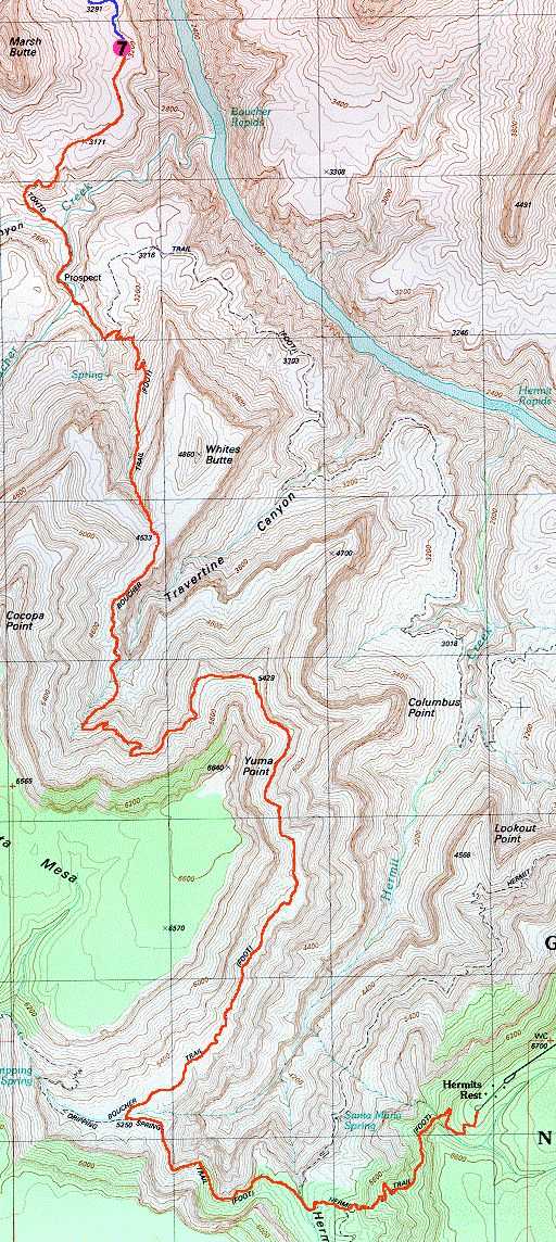
I was up at 4:00 and packed up and on the trail by 5:00. I wanted another early start today, just in case I decided to shoot for the rim. It only took 20 minutes to get over to the descent to Boucher Creek and by 5:45 I was down next to it. The descent into Boucher Creek from the west side was a milestone for my Grand Canyon hiking career and as soon as I set foot in the creek bed I had finally completed a task that I had set for myself many years ago. I had now hiked all of the south rim trails in the Grand Canyon between the Little Colorado River at river mile 61, and Elves Chasm at river mile 116. These were the only trails on the south rim with the exception of the trail down Havasu Canyon, which is on the Hasasupai Indian Reservation and not in the National Park, and the Royal Arch Route, which is not technically a trail (and also scares the crap out of me). Anyway, Boucher Creek looked absolutely nothing like I remembered it and it appeared to me that a large flash flood had come down Topaz Creek, the western tributary of Boucher, recently and done some rearranging of things. Topaz was currently dry but Boucher was flowing at a pretty good rate even though it was very shallow. I had to construct a small dam to get some water to pool and then dipped the pot from my mess kit into the pool to get water to filter. I was there for a little more than a half hour while I topped off all of my water bottles and ate some breakfast (Slim Jim and snack mix), the first of many small meal stops I would be making during the hike up and out. I also tried to super-hydrate myself and drank almost two liters of water while I was there. At 6:25 I started up the creek towards the site of Louis Boucher's homestead and the Boucher Creek camping area. I stopped to take photos of the remains of the orchards and the Boucher cabin. That did not look familiar either and I could have sworn that it still had a roof the last time I was down here. All that was left now where the walls and fireplace. There were a couple of guys camped there, the first people I had seen in three days, and I stopped to talk to them for a while. They were planning on doing a day hike over to Slate and I gave them an update on the trail conditions and the water availability. I was having trouble locating the trail out of Boucher Creek and it was because they were camped virtually right on top of it. Continuing on, I reached the eastern junction of the Boucher/Tonto trails at 7:15 and began the long grueling climb up Boucher Canyon, towards the Redwall, Whites Butte, the rim and civilization. I reached the base of the Redwall at 7:45 and took a 10 minute break before starting up through it. It was nice and shady and cool in the ravine used for the ascent and there was no sun until I got to the very top of it. The climb is rough in spots because of all of the brush and the general steepness of the trail but it was not that bad. I was through the Redwall, and right next to Whites Butte at 9 am on the dot. So far the morning had gone exactly as planned and I was right on schedule. I still felt very good but hunted down some shade behind a large rock for a rest and some more breakfast (another Slim Jim and some more snack mix). The air tours had ended at 6 pm the day before and started up again at 8 am today, while I was climbing up through the Redwall. It was non-stop air traffic right now and I made up my mind that I was definitely trying for the rim. There was no way I wanted to listen to this all day today and then all morning again tomorrow. I started moving again at 9:25 and worked my way along the top of the Redwall back up into the canyon behind Whites Butte, where the trail continued to ascend through the Supai Formation. This took a long time and I rested frequently. There was some shade but most of the trail was directly under the sun and it was getting warm. This is probably the worst section of the Boucher and I knew that once I got through this I would have it easy for a while. The trail is very cluttered though the Supai and is always jumping all over the place. There are also some rough spots that require the use of both hands to climb up, around and over some boulders and rock falls. I still don't know why anyone would ever come down this trail, it would be a nightmare. At 10:40 I was at the top of the Supai and found some shade for a good long rest. I drank a lot of water and ate my last bag of M&Ms. Boy, did those ever taste good. My right heel had started to bother me during the climb through the Supai so I took off my boots and socks to give my feet a rest and a chance to cool down. At 11:00 I continued on only to find that I was not all the way through the Supai yet. There was still one rough section to climb through that works its way around a large rock fall. In about 5 more minutes I was finally above the Supai just below the Coconino. At 12:00 I rounded the north edge of the promontory that drops down from Yuma Point on the rim. I took another rest break and ate some more snack mix. It took two long hours to do the contour back to the junction with the Dripping Springs Trail and I arrived there at 2:00. That section of trail was worse than I remembered and involved a lot of little ups and downs as the trail work its way around numerous slides and rock falls. It took another hour to do the section of the Dripping Springs Trail and get over to the junction with the Hermit. I knew that I was slowing down and getting tired and planned to take another extended rest before starting up the Hermit. I was not looking forward to that. At 3:00 I was a the junction of the Hermit and Waldron trails, took the pack off and rested. I should have taken the boots off as well but I didn't. I still had another Summer Sausage left so I opened that up and ate about 1/3 of it with some tortillas and some more snack mix. I still had plenty of water and another package of Gookinade and that should be enough to get me up the Hermit to the rim. I started dreaming about the Klondike Bars that I knew they had at Hermit's Rest. I also started dreaming about pizza and beer for dinner. There was real food up there. At 3:15 I couldn't take it any longer and start up the trail. I started off at a good pace but my energy waned very quickly and I slowed to almost a crawl as I went from one switchback to the next. I took frequent rests and very soon it got the point that I would hike up only one or two switchbacks before I would need to stop. Some of these switchbacks were very long and some were pretty steep. This was horrible, I thought that I had eaten enough during the day but my body was running out of energy. I munched on the remains of the snack mix during some of the stops but this was pretty much gone and all that was left was crumbs. I still had the rest of the Summer Sausage but that would take too long to digest and really wouldn't help me now. Luckily I still had enough Gookinade left to get me out, I hoped. If I ran out of that, I still had the two liters of water from Elves Chasm, my emergency supply. I just slowed the pace, accepted the situation, and crawled back to the rim. At 4:45 I finally reached it, having taken just shy of 12 hours of hiking to get out. Once out I immediately headed for Hermit's Rest and drank two huge cups of lemonade and ate the long-awaited Klondike Bar. There was something to be said for civilization. So, what did happen to that two liter bottle of water from Elves Chasm? Well, that's a another story. |
|
|
|
|
|
|
|---|
|
|---|


