|
Day 3 - Tonto Platform to Garnet Canyon |
|---|
|
|
|
|
|
I was up at 5 am and immediately knew that I should have gotten up earlier. By the time I made my oatmeal and coffee for breakfast, ate it, broke camp and packed up it was almost 6:30 and the sun was well up. There was not a cloud in the sky and the view was magnificent. I had some problems with some mosquitoes while I was preparing and eating breakfast and didn't understand why they would be up here on the Tonto Platform. It didn't seem to me like there would be enough standing water around for them to be breeding in.
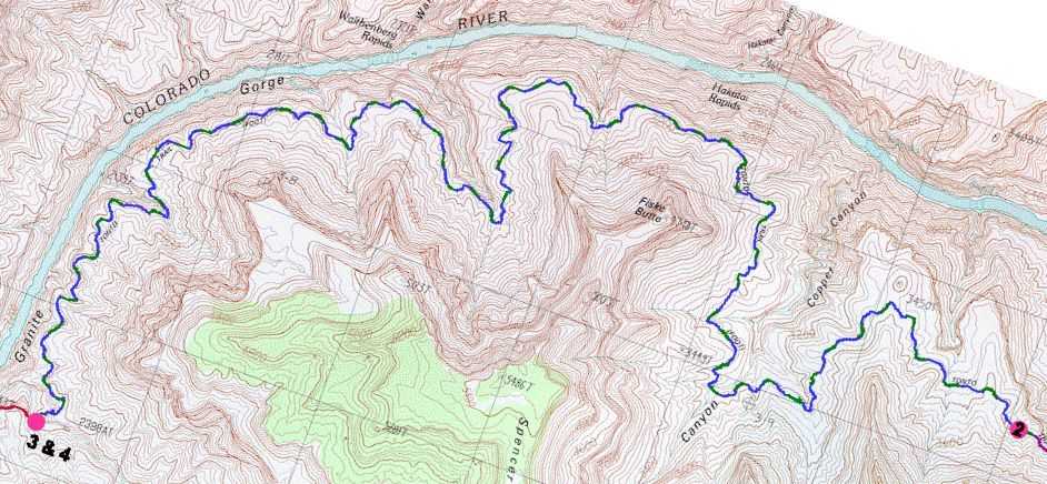
Once on the trail it immediately dropped and began to contour along the east side of a large drainage. At the time I thought that I was already heading into Copper Canyon and it was not until I got to the other side and started into the real Copper Canyon that I realized my mistake. It was at this point that I revised my original camping location of the prior night as I had neglected to account for another rather large, yet unnamed, drainage between where I was camped and Copper Canyon. Anyway, the trail started off being pretty easy to follow and then became somewhat more obscure and I had to constantly search out the few cairns that were available to confirm that I was really on it. I lost the trail a couple of times and had to back track to hunt it down again. Finally around 7 am I lost it completely and could not figure out where it went. I started to backtrack but was convinced that I was on the trail and that it had just dead-ended. I knew that this was, of course, impossible. My log said that I was near Fiske Butte when this happened but I know now that this was not the case as that was on the other side of Copper and I was no where near there yet. While I was standing there dumb-founded, trying to search out a cairn, I noticed a pair of other hikers considerably below where I was. They appeared to be following a trail and so I headed down to intercept them. We talked for a while and I discovered that they were coming from Garnet Canyon and Elves Chasm and had gone down the Royal Arch Route and were doing the loop. I asked about water in Garnet and they said that there was water there and that it tasted good. I was glad to year it as Garnet is normally a questionable source and I have heard that it can taste pretty nasty. They asked about water on the way up the South Bass Trail and I told them that aside from the river there were only the potholes on the Esplanade that I had seen two days prior. After we parted I continued on a ways until I came to a shady spot and decided to rest for a while (7:15 - 7:25). It was shortly after I started hiking again and rounded the next bend that I realized I was still on the other side of Copper. I knew that the small canyon I was going through was way too small to be Copper Canyon, but it really didn't sink in until I got a look at the real McCoy. Copper was not just large, it was huge, and it was 8:45 before I reached the other side. From my vantage point I had an excellent view of the river below and Hakatai Rapids. The morning was starting to get hot but there was still the occasional very cool breeze to cool me down. Next stop Walthenberg! After contouring around the north side of Fiske Butte I started into the nameless canyon west of Copper at around 9:45. At 10:15 I reached the backside, took a rest and added some Gookinade to my drinking water. Shortly after I started up again I met a women who was heading east. She was a solo hiker and was in day 3 of a 31 day trip. I thought I was doing a long trip, but I was only in day 3 of 9. She was planning on taking the Tonto Trail to the Escalante Route, to the Beamer Trail, crossing the river at the confluence with the Little Colorado and then going cross country up to and then out on the Nankoweap Trail. She had started her hike from the South Bass trailhead the same day that I did, but hitched a ride with the other river trip down to Elves Chasm. We talked a short while and then continued on our respective journeys. She claimed that the water in Garnet was a bit on the salty side. The western side of this large canyon had some bad sections of trail with lots of loose rock and dirt. It also had some pretty good exposure in places and it looked like a very long drop to the bottom. At 10:45 I was out of the main part of this large nameless canyon and started through a smaller one just west of it. By 11:15 I was out of the smaller one as well and had another fantastic view of the river below. This time I was looking down on Walthenberg Rapids and could see Walthenberg Canyon on the north side of the river. There were now lots of clouds in the sky but there was still plenty of sun and it was heating up. I found a huge rock that provided a great deal of shade and had a nice breeze coming up from the inner gorge and decided to stop for an early lunch. I figured I was well over half way to Garnet and guessed on about 3 more hours to go. Lunch consisted of starting into my second Summer Sausage, along with tortillas and some Chex Snack Mix. At 12:00 I started out again and began a contour along a lengthy section of fairly flat and level trail, which was a relief after all of the side canyons. The trail was now beginning to move towards a more southerly course which was a good sign that I was getting closer to Garnet. At 12:30 I came to the last nameless canyon before Garnet and started through that. There was more bad trail through here and like the first nameless canyon it was pretty much confined to the west side (which in this case would actually be the south side). At 12:55 I was out of this canyon and now heading almost due south. I passed through three more smaller drainages that slowed me down a little and then started into Garnet just after 1:30. The descent into Garnet Canyon was a bit on the weird side and I thought there must be an easier way. The descent into Garnet goes down through the first tributary canyon that you come to once you are in Garnet. It is quite steep, rocky, not well marked in some places and rather dangerous. After hiking all day it is not something good to get to when you are tired. Many of the cairns did not seem to make sense and this seemed like another one of those places where there may be multiple routes. It took about 30 minutes to figure out what was going on and work my way to the floor of Garnet Canyon. Once there I was pleased to see that there was plenty of water although it did not appear to be flowing. There were some good sized pools in some shady spots and there was life in them which is always a good sign. I found myself a good campsite, which appeared to be the only campsite near where the trail descends into Garnet, and proceeded to make camp. After setting up camp I wandered up the canyon a way to see what the water was like up there. I noticed that there was a small amount of water flowing (less then a trickle) between some of the pools and guessed that there must also be more flowing beneath the surface. The pools further up the canyon were more shallow than the one near my campsite so I returned to one of those to purify some water. When I first tasted the water it did not seem that bad. It was nice and cool and sort of refreshing. I did notice that it did not seem to quench my thirst though, no matter how much I drank. After I stopped drinking for a while I noticed the strange salty flavor and my mouth felt very strange. My mouth would continue to remain very dry for the rest of the day and through the night and it almost seemed like the water had caused my salivary glands to shut down. It was an odd feeling and not one that I was very comfortably with. After filling the water bottles I set off to search out the start of the trail over to Elves Chasm. This was pretty easy to find and started just a little more to the west (down canyon) of where the Tonto Trail came down in Garnet and ended. It looked to be pretty easy to follow and I could hardy wait for the next day to give it a try. I returned to camp to rest for a while before making dinner. I decided that based on the amount of time that it took me to get to Garnet that the hike back to the Ruby Use Area was not going to be a lot of fun. It was going to add 3-4 miles (at least) to what I had hiked today, which based on the terrain I would be covering would take about 2-3 more hours. If I started at the same time, that would get me to the boundary of the Ruby Use Area around 5 pm. There was still some time left for a buffer so I was reasonably sure that I could do it. At this point I was also thinking of hiking beyond the Use Area boundary and into Serpentine Canyon, which should have water. I knew that I needed to get an earlier start than I did today. The best thing to do would be to get up as soon as it was light enough to see, skip breakfast, pack up and leave, and then stop and eat something on the trail. Sounded like a plan to me. Just before starting dinner I heard a small rockfall down canyon but when I looked I could not see anything. A little while later I noticed a pair of Bighorn sheep walking among the rocks just below the Tapeats break. It looked like they were trying to head up canyon but were trying to avoid coming to the canyon floor, possibly because I was camped there. When I got out my binoculars to take a look there was definitely a larger one and one smaller one and neither had the typical huge horns. I guessed that it was probably a mother and child pair. Dinner tonight consisted of the remainder of the Summer Sausage and Lipton Noodles & Sauce, Alfredo flavor. I was getting tired of the noodle dishes already and wished that I had brought something else, like rice, with me as well. Since I now had extra coffee I also made myself some of that. After dinner the I noticed that the clouds had thickened up considerably through the day and so I put the rain fly on the tent. I did get hit by brief passing shower before going to sleep but later that night the clouds cleared out and the stars were out again. The racket from the frogs, crickets and other full-time occupants of Garnet Canyon was incredible. Luckily the frogs did not keep this up all night and stopped sometime before midnight. |
|
|
|
|
|
|
|---|
|
|---|


