|
"The Canyon Trip Promised to Matthew Huggins" |
|---|
|
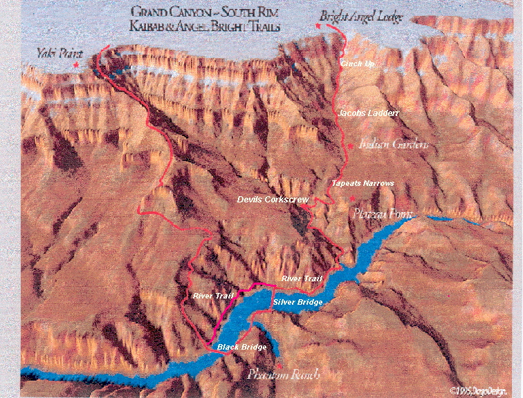
DAY 6. FRIDAY, AUGUST 16, 2002Piling out of bed at 4:30, Phil, Bill, Gary and I walked up to the kitchen window in the east side of the rear wing of the Mess Hall, and picked up the food sacks that had been prepared for us. In the early morning darkness we were on our way down the trail to the river in the 5:00 coolness. Before we reached the trails leading down to the beach we turned right to cross the lower bridge over Bright Angel Creek, and then hiked down to the Silver Bridge. This bridge affords hikers a short cut to the west half of the River Trail, and is the bridge supporting the pipeline that carries water across the Colorado River on its way up to the Grand Canyon Village. Water comes down from Roaring Springs Canyon, which is 11 miles north of Phantom Ranch at the head of Bright Angel Canyon. It is piped down the canyon alongside Bright Angel Creek, across the Colorado, and then up Pipe Creek Canyon to Indian Gardens all by the force of gravity. From Indian Gardens, water is pumped the last 3,000 feet or so up to the Grand Canyon Village. All of the water used in the Village comes from Roaring Springs, 20 miles to the north. Once across the bridge we turned right on the River Trail. Turning left would take one upstream to the short tunnel leading to the black bridge on the South Kaibab Trail. The River trail was blasted out of the thousand foot high Vishnu cliffs on the south side of the Colorado by the Civilian Conservation Corps back in 1936. This made it possible for mules and hikers to get from Indian Garden to the Black Bridge without having to take the tortuous Tonto Trail up on the Tonto platform. The construction of the Silver Bridge in the 1960s made it even easier for hikers to get to Phantom Ranch; however, mules still need to use the Black Bridge because they will not cross anything they can see through. A mile down stream from the Silver Bridge we came to the junction of the Bright Angel and River Trails at the mouth of Pipe Creek Canyon. Dawn's glow was gradually descending into the canyons by the time we started up the beautiful mile hike along Pipe Creek to Columbine Springs. Since none of us needed to use the facilities at the rest house located on the west side of Pipe Creek just above its mouth at the Colorado, we continued on until we were close to the beginning of the series of steep switch backs up through the Vishnu Schist cliff known as Jacobs Ladder, where we stopped for our breakfast break. There are three main barriers to those who want to get from the river to the rim. These are the 300 foot Tapeats Sandstone cliffs, the huge 4 to 6 hundred foot Redwall cliffs, and last of all the 300 foot high Coconino Sandstone cliffs. In this area of the canyon where the cliffs of the Vishnu Schist are prominent, they form a barrier that is more or less continuous with the Tapeats immediately above. Almost all of the trails from river to rim follow massive faults created by ancient earthquakes. These faults have created jagged breaks with a lot of rubble in them that has made it possible for desert Bighorns to form natural trails up the sides of the canyon. Bighorn trails were then improved by prehistoric Indians over centuries of use, and last of all some of the trails were improved even more by miners and others, principally Ralph Cameron, Pete Berry, Robert Ferguson, James McClure, and Niles Cameron who widened and leveled the Bright Angel Trail enough for donkeys, horses and mules to be able climb the cliffs. Miners and wranglers have given names to the parts of this trail that snake up through the breaks in the barriers. The switchbacks up through the Vishnu Schist at the head of Pipe Creek Canyon are called, "The Devils Corkscrew." Those through the Redwall above Indian Gardens are called "Jacobs Ladder," and the last ones through the Coconino Sandstone are called, "The Cinch Up." In the old days wranglers would stop to tighten the cinches on pack animals and animals with saddles for riders prior to entering the steep switchbacks down through the Coconino layer, so they called this section of the trail, "The Cinch Up."
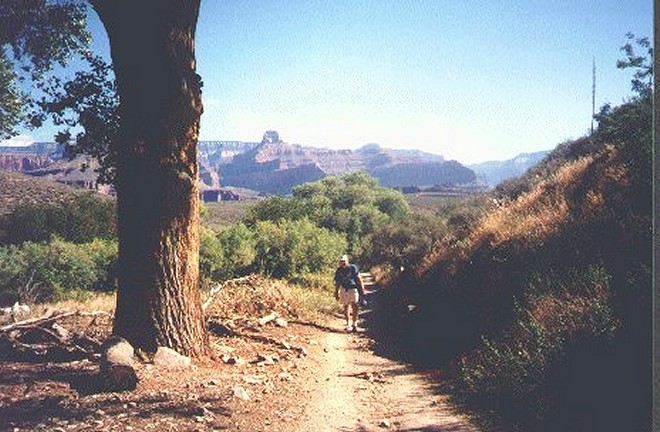
On all of our previous hikes up Pipe Creek Canyon we have seen deer and bighorn sheep, but this time we saw none. Perhaps we were too sleepy. However the willow, tamarisks and other greenery gave the canyon a pleasant atmosphere in contrast to the desert environment of the river trail. We took a pleasant breakfast break up near the beginning of The Devils Corkscrew, and then slogged up past the junction of Garden and Pipe Creeks and on up the switchbacks past Columbine Spring which comes in from the western cliff. We hiked early while the canyon was shady and cool. Taking it slow and easy in the early morning dawn we got up the three quarters of a mile Devils Corkscrew and into the Tapeats Narrows at the top of the Vishnu without any trouble. Once again I was fascinated by how clearly you can see the coarse grain sand granules of the Tapeats. It is beautiful. The last mile through the Narrows to Indian Gardens was along a gently inclined and shady trail, which gave us a welcome respite prior to attacking the remainder of the hike out. Our arrival time at Indian Gardens was 10:00 O'clock. Time for an early lunch break and rest before our final assault on the last 36 hundred feet to the rim.
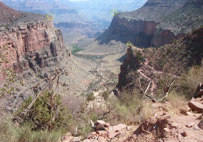
Alan Berkowitz in the "Grand Canyon Trail Guide" has written that it is only a mile up The Devils Corkscrew and on to Indian Gardens. Don't believe it. It is � mile up the Devils Corkscrew, and another mile from the top on to Indian Gardens. I paced it off in 1997, and again this time in 2002. I got the same results both times. If you are planning to hike in the cool of the early morning, which you had better be doing in the summer months, plan on that extra � mile distance. As far as we know the waters of Garden Creek have been used to irrigate crops in this region at least since prehistoric times. Ancient Indians were farming here as early as 1100 AD, and gardening was continuous up until the early 1900s when the Havasupais raised corn, squash and beans. They had a tough time of it, because Yavapai and southern Paiutes using the cross canyon trail here would often snack on the vegetables that the Havasupais had planted. Ralph Cameron filed a number of questionable mining claims in the Gardens area in 1901 in order to charge tourists fees for using the trails. After a lot of legal, and some illegal, wrangling the land was finally sold to the Federal Government in 1928. Gardening by the Indians gave the name to the place, and the name to Garden Creek. When Grand Canyon Village outgrew the water supply provided by tank cars from the Santa Fe Railroad , a pumping station was placed here in 1932. That served reasonably well until the 1960s when the pipeline from Roaring Springs and the Silver Bridge were constructed. Roaring Springs has been the source for the water of the Grand Canyon Village ever since. Since I was having a little difficulty keeping up with Bill, Phil and Gary, I decided to head on up the trail after finishing my lunch, assuming that they would catch up with me somewhere up around the 3-Mile or Mile-and-a-Half Resthouses. So I left the pleasant shade from the cottonwoods and the water fountains of Indian Gardens and started up toward Jacob's Ladder. Within a fe w hundred yards I passed the rangers home on the right. It is always well kept and neat. For the rest of my hike I took 100 to 150 paces (counting each time my left foot stepped) followed by a pause for 10 to 15 breaths. Taking small steps slowly; I got along the climb surprisingly quickly, and without much effort. Not much was blooming along the trail up the gentle slope of the Tonto group to the base of the Redwall, and neither was there much in the switchbacks of Jacob's Ladder up through the break in the Redwall. The views back down the canyon and across to the North Rim: however, were spectacular! At the top of the Redwall I took a brief rest to drink my fill, and replenish my canteen from the fountains and faucets at Three-Mile Resthouse. About half way up from the Resthouse to Two-Mile Corner I stopped to take a picture.
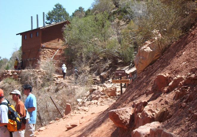
While looking out over the Tonto Platform and the path to Plateau Point I think of the two successful landings and the even more remarkable two successful take offs in the summer of 1922 by R. V. Thomas, a WWI barnstorming pilot, who was hired by Emory Kolb to perform these publicity stunts. And that memory brings to mind the memory of the three men of the Army Air Corps, who parachuted from a disabled B-24 during the night of June 24, 1944. They didn't know exactly where they were, but they saw the lights of Grand Canyon Village below them, and knew that they were near help. Think of their shock when they saw the lights come up as they descended, and then continue on up above them. They must have thought they were descending straight into Hell. They received an airdrop 3 days later, and were rescued on Jun 30 after six days on the Tonto Platform. Rounding Two-Mile-Corner, I soon saw the new building for toilet facilities located just down the trail from Mile-and-a-Half Resthouse. When we hiked up this way in 1997 the wood of the structure had not yet been stained, and it was a glaringly ugly scar on the landscape. The Park Service has now stained it so that it is not quite so startling, but it certainly doesn't blend into the landscape like the structures designed by Mary Jane Colter back in the 30s. What amuses me is that for years the National Park Service tried to get permission to demolish the historic Kolb Studio up on the rim on the grounds that it did not blend into the landscape, and was an eyesore. Then they designed and built this structure. I agree that it is a much-needed facility, and a big help to many hikers; however, I am amused at the end result of the design. Kolb Studio certainly blends in a lot more appropriately than this glorified outhouse does.
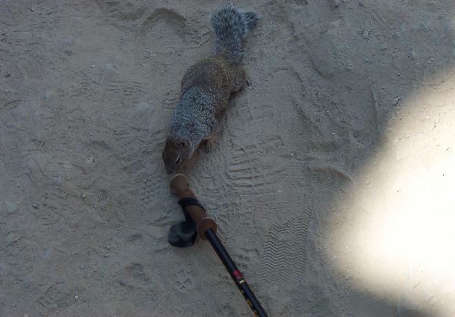
Continuing on, I rested briefly in the shade around Mile-and-a-Half Resthouse. The north-facing Coconino cliffs above the Resthouse provide cooler temperatures, more shade and moisture, making it possible for Gamble oaks and Douglas-firs to survive. The Resthouse is thus located in a microcosm of greenery more reminiscent of the North Rim. Shortly after leaving these pleasant surroundings I climbed into the last great barrier, the switchbacks of the Cinch-up, which took me up to the 2nd tunnel at the top of the Coconino Cliff. I think the evidence of the grand dropping of the east side of the fault is more evident here than anywhere along the entire Bright Angel Trail. You are switching back and forth in such short hairpins that the massive white cliffs of petrified sandstone are right in your face at every turn. You can't miss the evidence of that cataclysmic fault. Just after I emerged from the second tunnel, as I was leaning against the inside wall of the trail to take a drink, a fearless little squirrel tried to drag off my leki stick. Sneaky bugger!
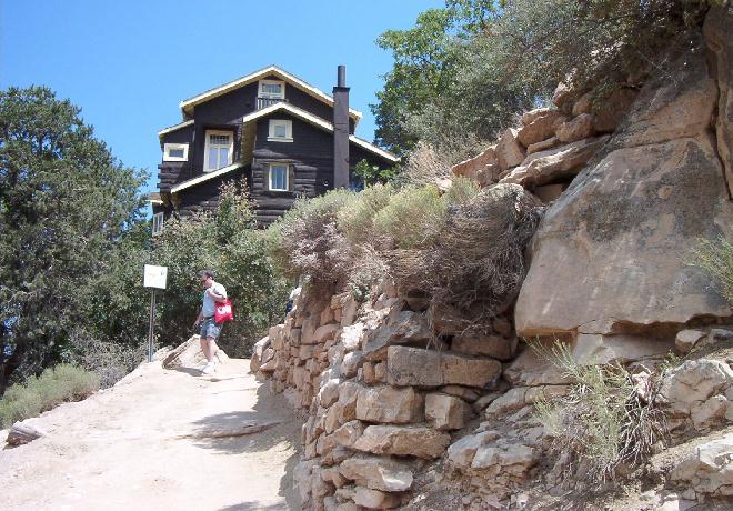
I was now at the top of the Coconino Sandstone, and the trail headed easterly for several hundred yards. This section seems as wide as a county road compared to many areas of trails, even compared to areas of the maintained trails, and as I recall ,it is almost unchanged from my first trip down here when I had just graduated from high school in 1947. In spite of my snail pace, and frequent rest stops, I saw no sign of Bill, Phil or Gary. I knew that they were in good hands with Al and Larry Roberts in their company so I continued on up through the rest of the Toroweap, and into the Kaibab, my last 250 million years of the hike. That's about how long I felt that I had been hiking. Then I entered the First Tunnel where I had seen footprints off the trail, and out on a ledge leading through the outer small tunnel on that 1947 hike. I was 17 and felt immortal in those days, and very nearly hopped over to crawl through the outer tunnel myself. Fortunately, our town pharmacist, Gary Olrich, talked me out of it. Today, just thinking about doing such a thing makes the back of my neck tingle. At last the beautiful Kolb Studio came into view. After climbing up from Phantom Ranch, the sight of that studio which we know is on the rim is always a beautiful sight. It was lovelier than ever this year.
An added pleasure was the fact that the left fork of the Bright Angel Trail, which led right up to the entrance to the studio, was again open for foot traffic. When we were here in 1997 it had been closed. I remember Bill's famous response when I wondered why such a pretty, and obviously convenient section of the trail would be closed to foot traffic, which made it necessary to hike a couple of hundred yards extra on the mule trail to the top, "The Park Service found out that it was too much fun so they put a stop to it," was his reply. Much to my surprise suddenly I was up past Kolb Studio and on to the pleasant walkway past Lookout Studio and between Bucky O'Neal's cabin, the Bright Angel Lodge, and Hopi House on the right and the magnificent view of the Canyon on the left. And I had made it by about 2:30 pm, which was a lot sooner than I had expected. By the time I had checked into the rooms previously reserved by Phil Roberts, he had arrived, then Gary Truitt appeared and then his speed-hiking son, Steve, who had probably been loafing around the Bright Angel Lodge for nearly half a day. Youth has its advantages. The rest of our group came straggling in under the shepherding of Al and Larry Roberts. Ever thoughtful Jennifer came up with her granddaddy Bill. I think she feigned fatigue in order to be with him. Jennifer is like that. After hauling our gear over from the mule barn, we cleaned up for supper. We ate at the Arizona Room. It was called the Arizona Steakhouse the last time I was here, and I was a little worried as to whether or not the quality of food and service would also be changed, and whether the change would be regrettable. It was not. It is still my favorite restaurant on the South Rim. Some final thoughts. First, a couple of things bother me about our use of the water of the Colorado. For one thing, there is a tremendous amount of evaporation that takes place in the concrete canals that carry river water to Phoenix and the surrounding farmland. Over 2,500 years ago the Persian Empire irrigated the southern Iranian desert by sending water from the melted snows of the Elborze Mountains in the north through huge concrete tunnels called ghonauts. The tunnels prevented evaporation during the transport, and there was plenty of water to irrigate the desert to produce crops of wheat, watermelons, pomegranates, peaches, dates and so on. If the ancient Persians were smart enough to do it that long ago, why can't we do it now? Another thing is the allocation of our water. For example, a lot of Colorado River water now goes to Southern California. Irrigation of pastureland in California consumes one-seventh of the states water. The cattle industry provides one-five-thousandth of the states economy. Michael Ghiglieri, a well-known river guide and author says that to get that kind of preferential treatment it is obvious that cows are sacred in California. Other facts that Ghiglieri has brought out include these:
I don't know how long the law requiring 8.23 million acre feet of water a year to pass through Lees Ferry to supply the lower basin states will go unchallenged, but I think the present drought is calling attention to this very serious problem. Fresh water in the West is a precious and limited commodity. Second, as I was reviewing my notes to prepare this report, I learned that Kenton (Factor) Grua had died. He died on August 15, the day that Scotty and I had been talking about him, about what a great guy he was, about what an excellent oarsman and guide he was, and how he had become occupied more in leading scientific expeditions than in tourist travel. His passing was a shock. You can read bout it at the following site: http://boatertalk.com/forum/RaftZone/227294. Factor had been our group leader on our 1997 trip. We had grown to really like him. All of us miss him.
Finally, I think that Jennifer has been moved by her experience here in the canyon, as are nearly all of those who spend time in it. It has an intangible effect on you, not because it is one of the wonders of the world, but because it is grand. It had that effect on Powell, and that is why he named it the Grand Canyon. Donald Hughes says in his book, In the House of Stone and Light, "one aspect of the Grand Canyon's natural scene is an intangible element, impossible to define. There have always been individuals who have found the Canyon mysterious, filled with awe-inspiring power, strangely both attractive and repellent, beautiful and charged with meaning. One poet has said that it has 'power upon the soul of man, to lift him up through wonder into joy.' " Bob Groves |
|
|
|---|
|
|---|