|
"The Canyon Trip Promised to Matthew Huggins" |
|---|
|
DAY 2. MONDAY, AUGUST 12, 2002Most of us were up by 6:30, and sleepily packing up our gear while sipping on our coffee from the neat traveling mugs that OARS provided for us. This is a tradition with OARS and Dories. Breakfast of eggs, toast, sausage and fruit was served at 8:30, and we were on our way down the Colorado by 9:45. After a short run we came to Boulder Narrows. We get an idea of the power of the Colorado at flood stage in the days before Glen Canyon Dam was built by looking at the driftwood lying on top of the boulder. This driftwood has remained there ever since the flow of the river has been modified by the controlled release from the dam. It is impressive.
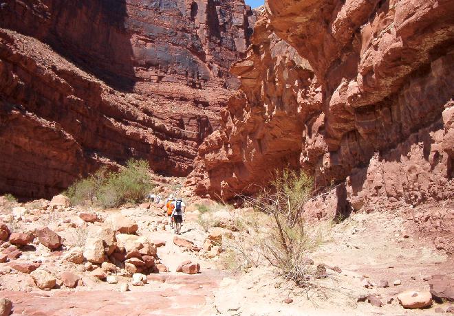
Shortly after passing through the narrows we arrived at North Canyon at mile 20.5. It was 10:15 am. The North Canyon hike is an easy half-mile or so up the canyon to the lovely, crystal clear pools that lie in narrow, smooth walled pockets or bowls in the red Supai. Bill told me that some of the younger guys had tried to walk around the upper pool by using toeholds in the sides of the bowls. This had resulted in some impromptu swimming, and laughter and fun
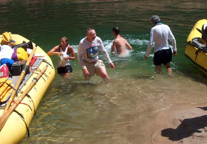
Although the hike up to the pools is an easy one, my vertigo has progressed to the point where, even using two Leki Sticks I was having such a difficult time keeping my footing that I turned back at the first incline. I could have made it, but I would have been a hold up for the rest of the group, and since I have been to North Canyon twice before I decided to hike back down to the beach. Kevin and Jennifer, of course, had a great time. With temperatures close to 100 degrees in the side canyons the North Canyon hikers easily worked up a sweat on their way back from the pools. A brief dip in the river cooled off some of smarter hikers.
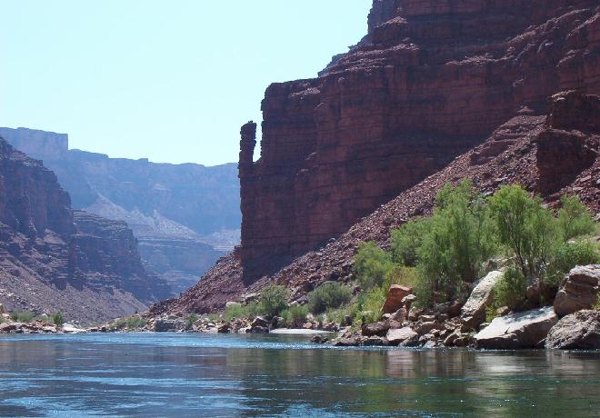
After the swim we took a very short run down to a beach on our left at mile 23, where we stopped for lunch. Cruising downstream after lunch the first obvious structure that got our attention was the a pinnacle of red rock in the upper Supai on our right that goes by the name of "Long Indian Dick." The adjacent rapid was known as "Indian Dick Rapid" ever since it was given this name by a couple of river guide geologists, George C. (Black George) Simmons and Parkman (Perky) Brooks back in 1955. On their first trip in Marble Canyon, not being familiar with the water, they flipped in the rapid below the now famous rock formation. In the process of swimming to shore and righting their boat they had plenty of time to look at, and comment on the prominent Supai pinnacle. They named it on the spot. Simmons included it in his next book, "River Runner's Guide to the Canyons of the Green and Colorado Rivers with Emphasis on Geological Features: Marble Gorge and Grand Canyon." As Nancy Brian has said on page 26 in her publication, "River to Rim," no doubt with a chuckle, "Rumors that this stone tower is named after an Indian named Richard who kept lonely ladies company while their boy friends and husbands were working on the river can now be dispelled." "Indian Dick" was still the official name in the third edition of Larry Steven's book, "The Colorado River in Grand Canyon, A Guide" that was the Guide was used when Bill, Phil and I rafted with OARS from Bright Angel Creek to Whitmore Wash in 1993. By the time of the publication of the 5th edition, which we used on our trip with Dories from Lees Ferry to Bright Angel Creek in 1997, the name had been changed to "23 and Half Mile Rapid." Apparently the U.S. Government authorities determined that "Long Indian Dick" was not politically correct. Scotty Stevens tells us that the original name has since been restored. Thank goodness. Scotty has suggested that the name should be "Tall Anasazi Richard," but (thankfully) so far his suggestion has fallen on deaf ears.
Our smart remarks about the famous Supai phallus were soon cut short, and we almost missed noticing the fact that the layer of Redwall Limestone appeared here, because we were entering the "Roaring Twenties." In rapid succession we ran Indian Dick, 23 ½ Mile (the real one) 24 Mile, 24 ½ Mile, 25 Mile (Hansbrough-Richards) Cave Springs, Tiger Wash, MNA Rapids, and finally 29 Mile Rapid. That was 9 rapids, with soaking wet dunkings in 5 ½ miles of river running. No wonder we froze to death when we did this on a cold, rainy day with Dories 5 years ago. On our present trip, during a cloudless, hot and sunny day, the dunkings were welcome. There followed a mile and a half of pleasantly calm water as we drifted down to the beaches of South Canyon with their Anasazi ruins and ancient petroglyphs on the right
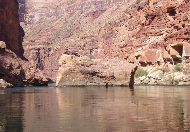
Without stopping to look at the petroglyphs or the ruins, or stopping to climb up to Stanton's Cave, a disappointment to me, we gently cruised around the bend past Vasey's Paradise on the right. John Wesley Powell was so impressed with the greenery and colorful blossoms made possible my springs in the Supai cliff that he named the place Vasey's Paradise, in honor of George W. Vasey, a physician and botanist, who had accompanied Powell on his exploration of the Rockies in the summer of 1868. Of this area Powell wrote, "The river turns sharply to the east and seems enclosed by a wall set with a million brilliant gems. …On coming nearer we find fountains bursting from the rock high overhead, and spray in the sunshine forms gems which bedeck the wall. Rocks below the fountain are covered with mosses and ferns and many beautiful flowering plants." It is a pretty site, but not quite that pretty. Powell was a very good writer, but at times he tended to hyperbolize. Nancy Brian tells us that in the Redwall Limestone solution caves above spelunkers have found 2 ½ miles of passageways. Care must be taken in climbing up to these caves as the rocks here are covered with poison ivy. A mile beyond Vasey's Paradise we came to the Redwall Cavern. This is a huge cavern that has been cut into the rock cliff at river level by the sand and gravel slurry-like water of the pre Glen Canyon Dam days when the force of flood currents scowered it out. Powell called it "…a vast half-circular chamber, which, if utilized for a theater, would give sitting to 50,000 people." He noted that at high water "…the floor is covered with a raging flood." This is another example of Powell's propensity to dramatize in his reports. There is no doubt that the cavern is huge, but when you think about a structure the size of the Rupp Arena in Lexington, Kentucky with a seating capacity of 20,000, and notice how much larger it is than the Redwall Cavern, you get the idea. I wonder if Powell would have stretched his dimensions so this much if he had thought about the fact that someday so many others would view the river as he did. Robert Stanton, who originally had idolized Powell, upon studying Powell's publications in light of his, Stanton's, own explorations of the Canyon, later came to view him as an ordinary man who had strengths and weaknesses like all of the rest of us.
Exploring the Redwall Cavern to everyone's satisfaction took about an hour of the afternoon. As we boarded our boats I noticed that the hearing aid for my right ear was not in the little water proof plastic bag where I had kept it along with my camera. I guess it was lost somewhere in the frequent unwrapping and wrapping of the camera required to protect it from our frequent dunkings during our run through the "Roaring Twenties." It was no great loss, because I had a couple of spares with me, but it was frustrating. From Redwall Cavern we had a leisurely cruise down tranquil waters, appearing to get ever deeper into the Redwall Limestone layer. The illusion of rapidly entering a deep abyss is created by the fact that the level of the cliffs above is rising by 75 feet a mile. Therefor, even though the river is descending only 8 feet a mile, the rafts are being swept into a much deeper canyon than would be expected at this gradient. Because of its compact, smooth appearance, Powell had originally thought that this layer was marble, and that is why he named this part of the canyon "Marble Canyon." Actually this densely packed limestone and dolomite (magnesium bearing limestone) was deposited in a shallow sea during the Mississippian Period approximately 335 million years ago. It forms a massive cliff from 540 feet thick in the east to 700 feet in the west. Fossils of sponges, sea lilies, brachiopods, corals, and nautiloids (both straight and coiled) have been found in this layer. The deep red color has been caused by iron oxide stains that have leached down from the Supai and Hermit Shale above. The true color of the so-called Redwall, according to Larry Stevens, is ivory with black dolomite bands. Personally, I have not seen the ivory color, but have seen plenty of the dark dolomite in places where segments of the superficial red stained layer has chipped off. We arrived at Nautiloid Canyon around 4:00 O'clock, which gave us plenty of time to set up camp leisurely, and shoot the breeze with each other. Dinner was baked salmon, salad and broccoli along with lots of other dishes that I don't remember except that they were all good. Shooting stars provided a pleasant display in the sky during the night.
|
|
|
|---|
|
|---|