|
"The Canyon Trip Promised to Matthew Huggins" |
|---|
|
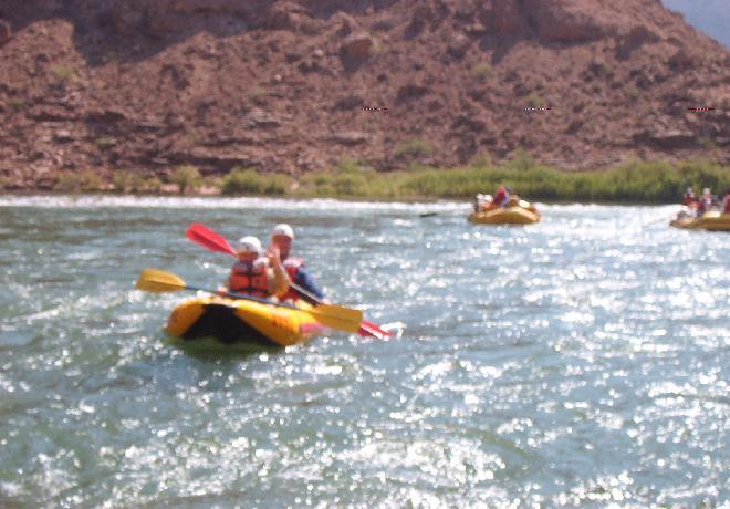
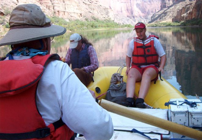
DAY 3. TUESDAY, AUGUST 13, 2002Tuesday dawned bright and clear. We were up, having coffee and stirring around by a little after 6, and had an early breakfast of scrambled eggs, hashbrowns, cut fruit, biscuits with jelly or jam, juice and more coffee at 6:45 am. Surprisingly, even though we got an early start nobody suggested that we take a climb up into the well known cave of nautiloid canyon. On previous trips this had been a fascinating place where it's possible to view the fossilized remains of prehistoric nautiloid creatures that are distant relatives of families of the squid and octopus. Cruising down reasonably calm water below 36 Mile Rapid, the crew made a couple of inlflatable kayaks available to some of the adventurous passengers.
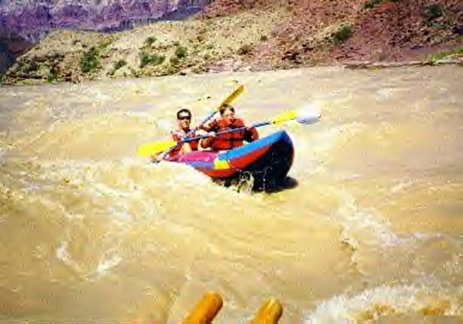
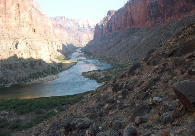
As we made our way down the calm waters of mile 39 and 40 we noticed the holes that had been drilled into the canyon walls in preparation for the construction of Marble Canyon dam. This dam was fortunately blocked by David Brower, executive director of the Sierra Club. He overcame the strong influence of Floyd Dominy, commissioner of the Bureau of Reclamation, who (supported by Senator Carl Hayden) in 1964 began pushing for dams just below mile 39 in Marble Canyon and near mile 228 in the Grand Canyon. The Marble Canyon Dam, and the Hualapai or Bridge Canyon Dam very nearly became a reality. Brower won over a large number of voters by publishing his views in the Washington Post, the New York Times, the Los Angeles times, and the San Francisco Chronicle. When the Bureau of Reclamation argued that the dams would improve the Grand Canyon by making it possible for boaters to get into side canyons, and closer to the cliffs, Brower responded with his famous question, "Should we also flood the Sistine Chapel so tourists can get nearer the ceiling?" The battle is not yet over. The Hualapai Indian Tribe is still agitating to have the Bridge Canyon Dam built along with a projected casino in order to attract tourist trade to its reservation. Gliding past Buck Farm Canyon`and Bert's Canyon we prepared to enter the first significant test of the day, President Harding Rapid. Albert (Bert) Loper, the Grand Old Man of the Canyon, was just short of his 80th birthday when he died while rowing 24.5 Mile Rapid in 1949. It is generally thought that he died of a heart attack, and generally thought that this was the way he wanted to die. His boat was found lodged on a rock bar immediately upstream from this unnamed canyon, at mile 41.25, so it was given the name "Bert's Canyon." Five years ago Bill and I had successfully run President Harding in a kayak. It had been a lot of fun. This year two kayaks also ran it with success, and it was even more fun, because it was a warm and sunny day with almost crystal clear water. This was a marked improvement over the brown, muddy turbulence and cold blowing rain off 1997. Claude S. Birdsey, chief of the USGS 1923 Survey Expedition named this rapid for President Harding while the group was camped at this site on August 10. By radio Birdseye learned that August 10 was the date set aside as a memorial day to President Harding, who had been assassinated on August 2. Therefore Boulder Rapid was renamed in Harding's honor. We continued on beyond President Harding Rapid and the grand hairpin turn around Point Hansbrough. This point was named by Robert Brewster Stanton for Peter Hansbrough, one of Stanton's boatmen who had drowned at 25 Mile Rapid in 1889. That was the expedition that had to be absndoned, with Stanton caching his boat and supplies in Stanton's Cave. In 1990, on his second, and successful, attempt, Stanton had found Handbrough's body (easily recognizable by the clothing) washed ashore at this point.
Two miles down from Point Hansbrough we came to Saddle Canyon, where we stop to give those of us who are idiots the chance to hike in the heat up the canyon. In spite of Rob's adequate warnings, some of our hardier members, including Phil Roberts accept the challenge. Us smarter ones rested in shade until they returned for lunch. The remainder of the afternoon was spent in a leasurely cruise down the placid waters of the river to Nankoweap Rapid at mile 52. About 2 miles upstream from the Nankoweap Creek delta we cruised through a stretch of river with nice campsites on either shore, and when we could see through the tamarisk trees we were able to notice the relatively soft mudstone and shale layers of Bright Angel Shale that was appearing at river level. This layer of rock is the middle layer of the Tonto Group. It is so soft and crumbly that it is easily eroded, and as it erodes it washes away back under the harder and stronger layers of Muav and Redwall above it. Having been undercut, huge chunks of unsupported, heavy Redwall break off, and roll off down into the canyon. This leaves a broader and broader section of exposed Bright Angel Shale with a receding cliff of Redwall or Muav and Redwall above it, and this is how geologists explain the development of the broad Tonto Platform that lies below the massive Redwall and Muav cliffs and above the 300 or so foot Tapeats Sandstone cliffs. As mentioned before these three layers, the Muav Limestone, the Bright Angel Shale and the Tapeats Sandstone make up the 540 million year old Tonto Group. By the way, the pretty tamarisk trees, through which we observed the rising layers of Bright angel Shale, are not native to the Canyon. However, they have become ubiquitous in the 50 years since they were introduced.. My friend, Jimmie Davis says that ubiquitous means "They are all over the damned place." Tamarisks, native to the Middle East and sections of China, also known as Salt Cedars. The were introduced into North America in the 1850's, because botanists had noted that this hardy species would thrive almost anywhere and in almost any kind of soil. They were brought over here for landscaping and erosion control. In the Southwest they were planted primarily for erosion control. Unfortunately they soon got out of control. Initially it was thought that the introduction of tamarisks would be highly beneficial for many reasons. For example, agriculturalists were aware of the writings of Nicholas Culpeper (1616-1654) one of the foremost figures in herbal medicine for his time. In his book, The Complete Herbal, he wrote, "A gallant Saturnine herb it is." and pointed out a number of therapeutic uses. ( I get a kick out of this.) "The leaves, young twigs, bark and/or roots, when boiled in wine produced a drink that would, stay "…the bleeding of the hæmorrhodical veins," … excessive menstrual flow, "…jaundice, cholic and spitting up blood,…" It would also either cure, or reduce the effect of, "… the biting of all venomous serpents, except the asp;…" This same medicine, if applied topically, was, "…very powerful against the hardness of the spleen, and the tooth-ache, pains in the ears, red and watering eyes." Now if you took the same "decoction" and added some honey, (how much honey was not recorded) he said that it, "…is good to stay gangrenes and fretting ulcers, and to wash those that are subject to nits and lice." He goes on to tell us that, "Alpinus and Veslingius affirm, That the Egyptians do with good success use the wood of it to cure the French disease, as others do with lignum vitæ or guiacum; and give it also to those who have the leprosy, scabs, ulcers, or the like." Since the ashes of burned Tamerisk, "…quickly heal blisters raised by burnings or scaldings."and "… helps the dropsy, arising from the hardness of the spleen,…"it is best "…to drink out of cups made of the wood … for splenetic persons." Oh, and "It is also helpful for melancholy, and the black jaundice that arise thereof." Soon it was discovered that these trees consumed a prodigious amount of water. A mature, large tamarisk is capable of transpiring up to 1100 liters of water every 24 hours. Small streams have been sucked dry by these pests. Then other problems became evident. We learned that for good reason this tree is also known as the Salt Cedar. It can grow in brackish and other mineral water. It is able to do this because it has the unique capability of purifying water for its sap by concentrating minerals in it's leaf tips. It does this everywhere it grows. When it drops its leaves, and the leaves decay in the soil, they don't enrich the soil as the leaves of other plants do, but they ruin the soil by making it more salty. As the years go by other plants find it harder and harder to live in the progressively more mineralized and salty soil created by the tamarisks. Meanwhile the hardy tamarisks continue to thrive. Besides all of this, the salinity of the leaves makes them unpalatable to insects and, so the trees don't provide a very good habitat for riparian life. Because of this characteristic they have virtually no enemies to keep them in check. Each Tamarisk produces up to 600,000 seeds a year; seeds that are blown on the wind to start new plants. In addition new trees start from shoots sprouting up from roots of old trees. When conservationists try to clear an area by cutting them down, often many new shoots sprout up from rootlets left in the ground, and the end result is an even more dense growth of tamarisks. So now you know why for nearly half a century agricultural experts have been trying to find a way to curb the spread of these pesky and stubborn plants. So far their best efforts have met with a resounding failure. As we rowed through the reasonably gentle Nankoweap Rapid around the delta that was created by the huge landslide thousands of years ago we noticed that there was plenty of camping room on shore, and plenty of space for our boats on the bank south of the delta. A gigantic earthquake, by the way, had caused such a landslide that a huge natural dam had been born, creating a lake that had backed waters all the way back up, and into Stanton's Cave. Since that time the river has overflowed the earthen dam, cutting a new channel that arcs to the east side of the river. This is what has formed the curve in the river and the Nankoweap Rapids. Please note that Bill Huggins takes exception to my comment that the Nankoweap Rapids are "reasonably gentle." Billie Prosser, his skipper for the day, had traded places with him some time earlier in the afternoon, allowing him to experience handling the oars of the suddenly, to Bill, big and unwieldy raft. As they approached Nankoweap she continued to enjoy relaxing while he rowed. He says he made it through the rapids, just barely missing a big rock, and without spinning around or any one of a number of things that he quickly realized could have gone wrong. It was much more difficult, and required a lot more energy than he had realized. I stand corrected. "Reasonably gentle" as descriptive of rapids in the Canyon depends on where you are seated, and what your responsibilities are.
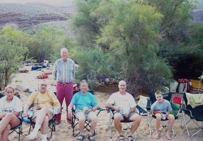
We had the boats securely tied, and all of our gear unloaded in plenty of time to select sleeping quareters, and still have time for leasurely activities. Many of us hiked the relatively easy trail up to the famous Anasazi Granaries. With my vertigo, knowing that I would have a good deal of difficulty climbing back down, I stopped about half way up, and took some pictures. This was just about the prettiest campsite of the entire trip.
As we settled down to eat our dinner, Rob Pitagora came over and handed my lost hearing aid to me. It had been found in the water in the bottom of one of the boats, and was about to be discarded as a piece of trash (it's a tiney, in-the-ear model) when Rob recognized it and saved it for me. That's almost as good as the saga of the ring on our trip with Dories in 1997. Still more amazing is the fact that once it thoroughly dried out it started working again, and it is still working. I have had it checked by Dr. Larry Byals, my hearing aid specialist, and it is just fine. After dinner we sat around, talking, joking, and reminiscing. We were becoming more and more relaxed with each other each day, and these evening bull sessions were developing into a very enjoyable part of the trip.
During the night, at 10:10 pm by my watch, there was a meteor or some object that shot through the sky from roughly South to North that was so bright that it lit up the camp at least as brightly as a flash of lightning. I have never seen such a bright object shoot across the sky. All of the campers who were awake at that time saw it, so I know that it was not my imagination. I have heard nothing about it on the news since we have returned home. I guess that it was a much larger than usual meteor. The effect was beautiful and dramatic. I will always remember it. |
|
|
|---|
|
|---|