|
Happy Campers - Late September/ early October 1996 - Bob Groves |
|---|
A few things stand out in my mind from this trip.
Here's the trip report.
Day 1 |
Day 2 |
Day 3 |
Day 4 |
Day 5 |
Day 6 |
Day 7 |
Day 8 |
Stats
Up at 5:30 for the free 6:00 a.m. coffee at the North Rim Lodge, then the 6:35 breakfast buffet, and finally off to loosen up our muscles on the Widforss Trail - the only trail on the North Rim that we have not yet hiked. I loaded up a new pack that Al Roberts had given me, and tried it out. Very comfortable. I liked it. It sure was thoughtful of him.
Bill Huggins, Phil Roberts and I did the hike. Phil's brother, Al, remained at our cabin getting things ready for the main hike. Besides, he'd arrived early and been hiking trails on the South Rim for nearly a week before the rest of us arrived. He didn't need any limbering up.
Once again, I fell into the routine of counting steps in order to measure distances. I measured 4.5 miles out to the end at Widforss Point. The book says it's 5.0. That's not too bad, and at least my estimate is less than what the book says, so if I measure a mile it is a little more than a mile - not less.
He told us that most Germans know nothing about hiking in the Canyon. They only drive out to the rim. He wants to let his countrymen know that there is more to the Canyon than parking lots and South Rim Hotels.
After giving the German a drink of water we followed the trail on around the point, but found that it gradually faded out, so we hiked up the hill to our left and returned to the picnic table for a snack before returning to the trail head. I measured 4.4 miles on the return trip. Close enough.
Just as we got back to our van at the parking lot it began to rain. Then on the drive back to the Lodge it began to sleet and hail. We picked up a pleasant couple who were hiking along the road from the campground store to the Lodge, and they were very grateful to get out of the weather.
I felt sorry for several young ladies, and a family with little children that were on their way out the Widforss Trail while we were on our way back. They had been dressed in shorts and T-shirts - not the sort of thing for sleet and hail.
Tried calling Peggy. Left a message on the answering machine. Then we ate supper in the big dining hall of the Lodge where through the huge picture windows we could look out over the canyon while we ate. After dinner we packed up our gear for our main canyon hike. I called Peggy, and let her know that all was going well. She asked if I had gotten the message that she had returned my call. I had not. We were both resigned to the fact that the Lodge personnel were not very dependable, but later that night Phil awakened me to let me know that Peggy had returned my call. He had taken the message, and forgotten to tell me. That's Phil, . . . even more scatter brained than I am.
At last we settled in for a good night's sleep.
Day 1 |
Day 2 |
Day 3 |
Day 4 |
Day 5 |
Day 6 |
Day 7 |
Day 8 |
Stats
Everybody up at 5:15. No free coffee this morning. The pot was already empty when we got to the Lodge at 6:15. By the time we had eaten breakfast, packed our "city clothes" and loaded them in Al's moth eaten truck, packed our camping gear in the rental van, and checked out of the Lodge it was 8:10 a.m..
The late start denied us the fun of spotting wildlife on the drive through the Kaibab National Forest en route to the Bill Hall Trailhead, but that element of interest was compensated for by the miles of charred forest that we saw. Reading about forest fires from our green South Georgia home is one thing. Seeing the miles of naked, blackened tree limbs is another. Marcia Martin, the pretty ranger who gave a talk at the North Rim Lodge the night of our return told us that most of these fires were controlled burns designed to clean up the forest floor in order to try to avoid a disastrous fire. That may have been, but if so, it seemed to me that some of these had gotten out of control. True, many areas were cleared of fall downs and underbrush while the thick, insulating bark of the huge ponderosas had protected the older trees; however, there were more than a few areas where it was obvious that everything had burned. Perhaps these were lightning ignited fires. Whatever. I'm sure that the Forest Service would say that they were.
Ward (Bill) Hall, by the way, was a Park Ranger who had stopped to help a wrecked motorcyclist back in 1979, when he was struck and killed by a passing motorist. The trail was named for him, and there is a monument placed in his honor near the
trailhead. I was surprised to learn that Monument Point, where the Bill Hall Trail begins, is not named for the monument to Bill Hall. It was named by John Wesley Powell on his exploration of the Grand Canyon nearly 130 years ago. In her book, "River to Rim" Nancy Brian doesn't say why Major Powell named it Monument Point, but if I see her again on an O.A.R.S. trip I'll ask her. (She is an excellent raft captain as well as writer.)
On one of our river trips Nancy told us that she had only capsized a raft once in her life. Unfortunately it was the raft in which her mother and her aunt were passengers. That's always the way, isn't it? Luckily no one was hurt, and nothing was damaged - except Nancy's pride.
For miles around the parking lot, the Bill Hall Monument and the trailhead the pinyon-juniper forest is completely burned. Nothing lives. There must have been a hell of a conflagration there this summer, and I'm not cursing.
We hit the trail at 10:15 a.m., and I mean hit. Loaded as heavily as I was I sat down and slid over many of the boulders that provided steep steps for the first descent, hitting the trail with my butt at the bottom of each of these "steps." After a while we were through the Kaibab Limestone cliffs, and had come to an easier part where we slabbed the steep slope westward past Bridgers Knoll. (It really is Bridgers. No apostrophe. The Bureau of Geographic Names, BGN has decided to avoid confusion by eliminating apostrophes. Good idea too - I think.)
What's the difference between a butte and a knoll? Phil wanted to know. I don't. Who does? According to my Webster's both are small mountains or hills with steep sides. Maybe a knoll is slightly smaller than a butte, or is it the other way around? When I was a kid in Kentucky we called them knobs. My folks in Ireland call them knocks.
While I was preparing to do this, Al, who is stronger and more agile than most guys less than half his age of nearly 63, had already descended with his heavy pack plus the extra gallon jug of water - which extra water he was carrying to be cached down on the Esplanade for our use on the way back out - and climbed back up. He saddled up with Bill's pack, climbed down, unloaded it and then did the same for me. Meanwhile his brother, Phil, climbed down the cliff with his own pack on, plus the gallon water jug that he was carrying. Nothing to it. My opinion is that those two guys are closely related to Darwin's missing link. There is no other reasonable explanation.
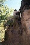
Dreading more of the slabbing along the steep slope I started out again. My vertigo was giving me more trouble than usual, so I was using my hiking staff more than usual, and really leaning into the high side of the trail; easy to do since the high side was usually right by my ear. But by being extremely careful I never slipped, and never really fell. I sat down a little more quickly that I intended to a couple of times, but that doesn't count as a fall - at least I don't count it as a fall. Anyhow, these sits (or seats) were always toward the uphill side, which is what the book says you are supposed to do. I was definitely going by the book here. I was not about to fall to the downhill side, and cartwheel out into the canyon below.
To my very pleasant surprise, very shortly after the descent down the Coconino cliff we came to the fault where an ancient slide made it possible to switchback down a more and more gradual slope through the Hermit Shale to the Esplanade.
The Esplanade is the top level of the Supai Group. We had traveled from a cool pinyon-juniper forest to a desert climate full of barrel cacti, Spanish Bayonets, (banana yucca) Mormon tea, hedgehog, prickly pear, Utah Century plants, (agave) and mesquite. In geologic time we had traveled from the Middle Permian Period of the Paleozoic Era 250 million years ago (Kaibab Limestone) to the Pennsylvanian Period of the same Era 285 - 320 million years ago (Supai Group.)
One of the things that always impresses me whenever I descend into the canyon is the abrupt change in color from the Coconino Sandstone to the Hermit Shale immediately below it. The Coconino layer is almost white. The Hermit Shale is a bright rusty red. There is absolutely no gradation from one to the other. The white layer lies smack on top of the red layer. And it always surprises me. Especially when I know that these rocks were formed by sediments along an ancient seashore and beach.
Near the lower reaches of the slope we cached our first gallon of water, labeling it with Al's name, and recording the date that we intended to pick it up. In addition we hid it well, because the Park Rangers tell us that they are having more and more trouble with hikers making off with water supplies that others have left.
Another 0.6 miles brought us to the junction with the Thunder River Trail. That's the one that we hiked last year. It is 2.5 miles to this junction by way of the Bill Hall Trail, while it is 7.5 miles to this junction by way of the Thunder River Trail. The descent is from 7200 feet at the Bill Hall Trailhead at Monument Point while only from 6400 feet at the Thunder River Trailhead 5 miles west at Indian Hollow, but with the five mile shorter distance the Bill Hall Trail is more popular with hikers.
Eighty paces past the junction we hid the remaining gallon of water under some rocks behind a huge juniper that we would be able to easily identify, and continued on our way.
I measure a mile from the Thunder River Trail junction to Ranger Rock. (That's the rock and ledge where the Park Rangers checked our permits last year. It makes a nice rest stop. Shady under the overhang.) Another mile and a half of easy walking brought us to a good campsite under a big overhanging rock which had a table high ledge under it - perfect for unloading our packs, cooking and eating supper etc., and as it turned out a nice place to stay in out of the weather when a thunderstorm came up.
Just before we came to that convenient campsite we passed a wash where two agave plants were growing side by side, perfect position for a photo of a couple of us standing between them. These were mature plants, right in the process of going to seed, - sort of like Bill at this time of his life. Of course I had to bring up this fact to him. He reminded me that he had shown a picture of a couple of these century plants with me standing between them to his grand-daughter's class at her school when he was asked to give a talk on the Grand Canyon. He had told the students that the agave were called century plants because they lived 100 years before they produced their seeds. (Actually they live about 25 years.) And he also mentioned that the two plants in the picture with their seed pods were not quite as old as the gentleman, (me) standing between them. Bill lies a lot.
I hope that they had tents. They would need them.
After dinner we lay around, doctored our wounds - raw places on Al's feet, raw places on Phil's feet, a blister on the medial side of my right big toe - and joked with each other. Mainly we marveled at the fact that last year we had hiked all the way down from Indian Hollow, across the Esplanade past the Bill Hall Trail junction, past where we now were camped, on down the Redwall, across Surprise Valley and all the way down to Upper Deer Creek Falls, and had done that all in one day. According to the book that was a 14 mile hike. Amazing.
I don't think it was quite that far, but it certainly was at least twice as far as we had hiked this day, and I felt nearly as tired. The extra weight of extra water and extra food on a much steeper trail must have been part of the explanation. Being a year older may have been part of it, but I didn't want to think about that part, and neither did anybody else.
Since it only cost me 2 quarts of water coming down the Bill Hall Trail, and about 1 quart for supper, I still had 5 quarts left. That was going to be more than enough for breakfast and the hike tomorrow down to Thunder River and Upper Tapeats. There is good, cold, clear water at Thunder Springs, and plenty of it.
Trying to sleep was a challenge, because a canyon wind came up, and blew like crazy. I had to get my head completely inside my sleeping bag to keep the sand our of my eyes and the grit out of my teeth, even with my eyes and mouth squinched tightly shut. Finally the wind died down a little, at least enough so that I could stick my face out and breathe, but then the storm clouds streamed in from the west, blotted out the full moon, and the spectacular show began. At times lightning would light up the entire canyon, and thunder would roll and echo from cliff to cliff and wall to wall. Other times the jagged streaks would be so far away that no sound would follow. Sometimes we could see them strike the rim. Sometimes they would disappear into the depths of the canyon. I have never seen anything like it. The only times I have been this interested in a thunderstorm was once when Peggy and I and Nancy and Bill were on my 21 foot Stamas out in the middle of the Gulf stream, and a sudden storm blew up, and once when we were fishing about 8 miles out from Walker's Kay when a streak of lightning shot down beside a huge thunderhead in the distance, and a waterspout developed along the path of the lightning strike. While westood spellbound by that dramatic event, Peggy said, "I WANT TO GO HOME!" That immediately broke the spell, and we skimmed the waves for Walker's Kay harbor, and watched the rest of the storm from our window in the hotel.
When the rain came down in the canyon that night we had been given plenty of warning, and we had our gear and ourselves safely under the overhang. We hoped that those two guys had time to get tents, (if any) set up. The storm lasted from 9:45 to 11:00. Afterward the air was crystal clear, the ground was fragrant, and the full moon was so bright that it nearly hurt our eyes. That night alone made the entire trip worth our effort.
Day 1 |
Day 2 |
Day 3 |
Day 4 |
Day 5 |
Day 6 |
Day 7 |
Day 8 |
Stats
5:45 a.m. was time to get started. Al used his small butane stove to heat water for coffee and oatmeal with cheese grits, and sand grits. Delicious. We were out on the trail by 6:45.
The rocky path descended easily for a half mile into and through a bowl which had been created by an ancient earthquake to a break in the top of the Redwall. The same quake had left a steep slope of rock, sand and gravel that had made it possible to construct a switchback trail down the 400 foot cliff to the floor of Surprise Valley.
There are a couple of stories as to how the Valley got its name. Nancy Brian says that E. O. Beamon, photographer as well as boatman on Major Powell's second Grand Canyon expedition, and George Riley, a prospector who also accompanied Powell on the second expedition, walked up Kanab Creek to Deer Creek. They had to scale a small cliff along the way, and when they got to the first ledge they were able to see what appeared to be a fertile valley. It surprised them, so that's what they called it. Actually what they probably saw was upper Deer Creek, and not the dry hanging valley high above which is now known as Surprise Valley. Michael Collier, in his book "An Introduction to Grand Canyon Geology" says that somehow ground water or water backed up by lava flow dams farther downstream accumulated, and lubricated the shales of the Bright Angel formation so that they could not support the weight on the heavy Supai layers above, and the entire 4 square mile area slid down to where it now lies. To the surprise of early geologists an entire sequence of rocks was found down at the bottom of the massive Redwall cliff rather than at the top where it belonged. So they found Esplanade layers both at the top and at the bottom of the intervening Redwall. There must have been a cataclysmic event of some sort, because the row of hills known as Cogswell Butte that lie between the valley and the Colorado are also made up of rocks that should be high above the Redwall. Surprise! Thus the name Surprise Valley. Take your pick.
In his book, "In the House of Stone and Light" J. Donald Hughes says that Beamon caused a minor gold rush, no pun intended, when he claimed to have discovered gold in Kanab Canyon. It didn't last long, but it did last long enough to motivate folk to build the Thunder River Trail in 1876 so that they could bring horses and pack animals down into the canyon. Lack of maintenance has made this impossible today, but you can see by the foundations that at one time it was a very good road, at least as good as the main corridor trails of the South Rim.
We climbed down the rough, rocky switchbacks of the Redwall for a mile and a quarter to the relatively level spot where we had rested on our way out last year. The maiden's face on the huge boulder above the east side of the trail is not quite as pretty this year, because a section of her nose has fallen off, but she still has her long flowing, black hair, and is easily recognizable.
Shortly before noon we dropped down 3/4 mile to where the cool path leads through the willows and tamarisk to Thunder Falls. We climbed high up to the base of the falls, explored the banks of the river, drank the cool water, napped under the cottonwoods, and generally had a very relaxing time in the middle of the day when the rest of the lower canyon was hot and dry.
Bill and I noted the height of the cliffs up to the entrance to Thunder Cave where the water roars out, and we both marveled at the fact that Michael Ghiglieri, (river runner, college professor, author, conservationist and explorer) had climbed up those cliffs, and entered the cave. We were not surprised that he scraped himself pretty badly when he descended. Later I learned from Nancy Brian that over 3,000 feet of caverns have been explored back in Thunder Cave. Why? There sure are a lot of nuts in this world.
The trail down Thunder Canyon is pretty steep in places. It has to be. Thunder River plunges down 1,200 feet in its half mile length, from a 4,000 foot elevation to 2,800. Its not a river. Its a roaring cataract. This trail was not constructed until 1926, and is in much better condition than most of the wilderness trails, so although it is quite steep, and is right on the edge of the canyon in several places it is about as easy a trail to follow as can be found in the Grand Canyon.
After about a mile on the trail, and an hour of steep descent we stopped under a cottonwood to drink, to rest and to doctor our feet, and while there we were delighted to learn from a group of hikers coming up from a rafting party on the Colorado that we were almost at the confluence with Tapeats Creek, and that the Upper Tapeats Campground was not more far beyond the confluence. I measured .4 mile from the cottonwood to the campground. We began setting up camp at 1:30 p.m.. We were still nearly 800 feet above the Colorado River, which is 2,000 feet above sea level at Tapeats Creek.
Remembering the suddenness with which the storm had arrived the night before, I set up my tent. It has a waterproof floor, waterproof lower sides, mosquito netting top, mosquito netting entrance and rear window, and a water proof retractable fly. The whole thing weighs a little over 3 pounds. Very handy. Very comfortable. Peggy ordered it for me from one of the (thousands of) catalogs that are sent to us back home. Occasionally one of the companies will threaten to stop sending us any more unless we place an order, but they never keep their word. The catalogs keep coming. Now and then we get a good deal from one of them - like my tent. In the winter I find them very useful for starting fires in our living room fire place, so I'm not complaining. They also make good reading in the john.
Upper Tapeats Campground is set under huge trees right beside the river. A beautiful location. Up the west side of the canyon the Park Service has built a chemical toilet. A very pleasant surprise. You don't appreciate a comfortable, sit-down toilet until you do without one for a while. Talk to the gals on the India Medical Mission Team from our Methodist church about that. They know what I'm talking about.
There was a strategically placed huge rock that provided a fair amount of shelter from the wind for our kitchen stove. It was behind this rock that we gathered to cook, boil the water actually, and eat our freeze dried meals.
We have learned that it gets pretty dark by 7:15, so we ate an early dinner, and turned in. In the canyon you learn to go to bed when it gets dark, and to get up when it gets light. It saves your batteries, both the inorganic chemical kind in your appliances and the organic chemical kind in your bodies. Not a bad way to live.
Day 1 |
Day 2 |
Day 3 |
Day 4 |
Day 5 |
Day 6 |
Day 7 |
Day 8 |
Stats
This was going to be an easy day, a rest day. Last year we had scheduled much too much for those of us in our golden years, (read "old codgers") and we had extended ourselves almost to the limits of our endurance to get out of the canyon. Not only were we exhausted, but Bill's LGL syndrome, a type of racing heart, had become manifest, very nearly requiring a request for helicopter transportation. Knowing that a combination of fatigue plus dehydration brought on that disorder, we were not going to let ourselves be placed in that sort of situation again. Plan ahead was our motto. Take it easy. Schedule easy
hiking days with a rest day every other day. At our age we had nothing to prove. Enjoy the canyon, we said. Take in the scenery. Leave plenty of time for photography and naps.
Naturally we were all up and eager to go at 6:00 a.m..
First we had to have coffee, then breakfast.
Coffee has a special flavor on the trail. It makes no difference what kind of coffee. On the trail, in the woods, by a lake, wherever. Outdoor air brings out the true aroma and flavor of that wonderful beverage. That's the way coffee was meant to be
enjoyed. If you haven't had coffee on the trail or in a hunting or fishing camp, then you really don't know what good coffee is. No day in the wilds should be started without coffee.
First we had to have coffee, then breakfast. Mine was my usual two packages of oatmeal and brown sugar. Excellent.
By 7:00 we were on our way down the easy path to the Colorado River. Two miles. Maybe two and a half. Piece of cake. As we strolled along Al commented on how pretty and how easy the trail was. Mistake! Exactly like commenting on the beauty of the weather when you don't have your umbrella.
Abruptly the trail went up a wash to our right. Up the side of a steep hill, then around a bend, then across a section where it had been washed out. Still, we were only a few hundred feet up - not really scary - and we were able to get across the washed out portion OK, but then there was another, and then we could see that the trail kept going higher up the side of the canyon while getting dimmer and dimmer with more and more of a slope which made our footing less and less secure, while at the same time the creek was going down farther and farther. That made our elevation above the canyon floor increase amazingly rapidly. Al scouted on ahead around the next bend. His thumbs down signal let us know that we had to look for another way. It was backtrack time.
Back on the easy part of the path we recalled that Bob Ribokas had talked about crossing the creek. With all of our planning neither Al nor I had brought Bob's trip report with us. Since Phil had traveled this same route about 3 years ago when we were down here on a raft trip with O.A.R.S. we were depending upon his memory. That was our biggest mistake. Phil is one of these guys who is a genius academically, but who has no sense of direction, no concept of where he is geographically and no recall of topographical features. Having no directions of any kind, and feeling your way by trial and error, we learned this day, was better than relying upon Phil. In my opinion he is by far the best oncologist in Georgia, and he is on a par with any anywhere, but he has - let's say - limited value as far as route finding is concerned.
Returning slowly along the banks of the creek to within a couple of hundred yards of the campground we spotted a marker indicating a crossing. Down by the water's edge we could see a faint wisp of a trail leading up the opposite bank. While we were debating as to whether or not we ought to attempt to cross, sure footed Phil stepped right in, and successfully made his way to the other side without mishap. Considering the swiftness of the current, and the slipperiness of the rocks on the
bottom, that feat was impressive. Following Phil's lead, plus hanging onto Al, while using my staff for additional support I was also able to get across without falling into the freezing water. Other than sloshy shoes, soaked trousers and legs and feet aching from the cold we were in good shape. Down the canyon we slogged along, gradually drying out as we went.
Our troubles were just beginning.
A half mile or so below the crossing the trail climbed the left, (east) side of the canyon, came out on a broad, flat ledge, and then abruptly ended. About 20 feet below us we could see the trail continuing on down the canyon, but we couldn't see how we could get to it. While the others were puzzling this matter I backtracked to see if there was another trail that we had missed, - one that would bring us along the bottom of the cliff to where we could see the continuation of the trail.
As I was diligently exploring the area for this other hoped for trail, a group of 5 or 6 people came cheerfully swinging along up the main trail.
"Are you Bob?" the leader asked.
"I sure am." I replied.
"Well I'm Bob too," he said, "and your friends are back there at the bottom of the cliff waiting for you. Have a good hike." And with that he happily lead his group on up the Tapeats canyon.
Returning to the ledge and cliff, I found the guys down below just like Bob said. They explained that the climb down was easy once you knew where the hand and foot holds were. They had discovered them by watching the raft group climb up. So I got on my belly, and slid over the edge while Bill and Al placed my feet into the toe holds, and in this way made an easy descent to the trail below. Piece of cake.
Not really.
But not really all that difficult.
Another quarter of a mile brought us to another problem. The trail branched. The high trail went up a steep slope to a narrow, sloping , rocky and gravelly trail along a high cliff before descending to the creek bank, while the low trail followed a bend in the creek on a slanting, ridged rock that was about five feet above water level. The rock was slanted at
an angle of between 60 and 75 degrees, but it was dry and ridged enough so that by hanging on with your finger tips and toes you could sort of crab sideways across it. The section was not long. I'd say it was bout as long as the room that I'm sitting in while I type this, which is 26 feet. But it was long enough to give you plenty of opportunities to fall into that swift, freezing water which may have been deep enough to be over your head. It certainly looked that deep anyway.
We decided that a fall from the slanting rock would be less damaging than a fall from the high cliff. About half way along the rock my toes gave way. The Adidas shoes that I was wearing, though giving me excellent traction everywhere else
that we had been, didn't quite give me the traction that I needed in this particular spot. While I was hanging on by my finger tips, Bill, who was right behind me - and who had excellent traction from the Nike walking shoes that he was wearing, stuck the tip of his hiking staff against the sole of my left foot, and that stopped the slide. With Bill coming along sticking his hiking staff against the rock just under my foot I was able to make it the rest of the way across the slanting rock to firm footing farther on.
Whew! Nobody fell in.
Phil once again took the lead, jauntily swinging down the trail toward the Colorado River. Once again we gradually climbed higher and higher up the canyon wall. On the opposite side of the canyon we could see a nice, flat trail going through the cottonwoods way down below along the Tapeats Creek bank. Bill mentioned it a couple of times, and even wondered out loud if we perhaps should have recrossed the creek somewhere, and - maybe - be on that other trail. Farther on, as we were approaching a bend, now a good five hundred feet above the creek, we spotted a tent in the Lower Tapeats Campground way down in the bottom of the canyon near the Colorado River, but Phil kept his cheerful course higher and higher. He said that he felt sure that as soon as we rounded the next bend we would see the switchbacks that would take us down to the river.
We rounded the bend. What we saw was another bend. Even higher. And the trail was now about twice as wide as our feet, covered with sand and gravel, and sloping toward the five hundred or more foot high cliff on our right. I slung my arm through the strap of my hiking staff, and used both hands to hang onto the cliff wall to my left. Later I removed my cotton gloves, so that I could get a better grip on the ledges and crevices in the cliff. Because I was hanging on with all 4 extremities vertigo was not a problem here. Stupidity was a problem, maybe, but not vertigo.
At last we rounded the final bend, and came out on a relatively level bench high above the Colorado. We could see for miles up and down the Grand Canyon. What we could not see was a way to get down to the river.
Phil took off again briskly hiking east. We followed for a half mile while the trail became dimmer and dimmer, and the stone cairns marking it became fewer and fewer, and farther between. (A couple of days later we asked some experienced canyon
wilderness hikers where this trail went. They had never heard of it.) At last Bill said,
"I don't think the rafters take this trail. It doesn't look like anybody has been on it in a long, long time."
Al and I agreed. Phil was far ahead, still hiking east into the wilderness.
"It's getting lonesome up here." Bill said.
At that point Al hurried on, caught up with Phil, and persuaded him to return. It was obvious that we were not getting anywhere nearer the lower Tapeats Campground.
We turned back. Let me tell you that I turned back with mixed emotions. I had hoped against hope that we would indeed find those nonexistent switchbacks that Phil was talking about, because I was a good deal less than enthusiastic about crabbing along that narrow, sloping trail along that high, high cliff again. But that's what we had to do, and that's what we did. And I've still got the sore, raw finger tips to prove it.
Sometime in the early afternoon we arrived back down at the creek's edge where we found some comfortable rocks to sit on, and enjoy our mid-day snack, and while there we noticed that we were taking a break right at the spot where the trail
recrossed the Tapeats Creek to the west side. We should have crossed here, and taken that easy trail down through the cottonwoods to the campground at the Colorado River. We briefly thought about it, but realized that if we tried it, by the time we returned to camp light would be fading; and we still had to negotiate that slanting rock, and we still had to climb that 20 foot cliff to get home, so we satisfied ourselves that we had gotten to the Colorado River, even though we were five or six hundred feet above water level when we got there. I bet not many people have been on that high trail that we found by accident.
Actually we returned to camp sooner than we had expected. We got there at 3:30. We probably could have gotten down to the Colorado at river level after all, but we were all so fatigued as it was that no one had any regrets.
This was supposed to have been a day of rest. Remember?
Bill checked around the camp for snakes. He found none, but just to be sure he got out his snake preventive, and served each of us a measured amount. We wanted to be sure to have enough to protect us from snakes every evening of the trip.
The only time that we have seen a snake in the canyon was on our first river trip with Canyoneers, and that was the only trip we've taken where Bill forgot his snake medicine. It was a badly frightened, pink Grand Canyon rattler, but it was still a snake.
After supper, and after sunset, as the early twilight was descending into the canyon, two athletic looking young men came up the trail. They stopped and asked how much farther it was to Thunder Falls. I told them it was about 1.25 to 1.4 miles. They thanked us, and said that they were up from a raft trip, and they wanted to see the falls. Bill mentioned that it would be getting dark soon. They were not worried about hiking in the dark, they said. They had a flashlight.
I noted that the blond guy had his hair fixed in dreadlocks, and had a Playboy Bunny tattooed on his left breast. The other guy had rings in his ears. They were both very pleasant, but I suspect that neither of them would take any sort of advice from a bunch of Medicare aged characters. They jokingly said that they'd be sure to wake us up on their return.
They didn't. We never did find out what happened to them. My guess is that they made it OK, but I'm willing to bet that they don't go hiking in the canyon after dark again.
Day 1 |
Day 2 |
Day 3 |
Day 4 |
Day 5 |
Day 6 |
Day 7 |
Day 8 |
Stats
It took little longer than usual for me to get ready for the day's hike, because I had to take down my tent, and I had let more stuff than usual get scattered around in it. Somebody had promised me that as the week wore on and I consumed my food that my pack would get lighter. Why didn't it feel any lighter? Why did it seem that I had more stuff than ever to cram into it? No doubt I had made the mistake of packing male and female items, and they were reproducing. In spite of the lack of
cooperation from my gear I was finally ready to break camp at 7:45.
On the way back up the Thunder River Trail we met a group hiking down. Two guys were from Boulder, and two guys were from Wyoming. My good friend, Mac Macfarlan, an OB-GYN man who was the best man at my wedding, is from Boulder, and Jack Roosevelt, a friend of my daughter Sarah, is from Boulder, but I didn't inquire to see if these guys had heard of them. Sarah may be my youngest, but she's 36, and so is Jack, and these guys appeared to be in their early 20's.
Somehow, as I hiked up the Thunder River Trail, leaning forward to keep from being pulled over backward by the weight of my pack, I missed the path to the falls. Before I realized where we were, I saw that we were high above them. We stopped at a saddle in the trail, and took our packs off. Bill and I relaxed while Phil and Al hiked back down to Thunder Falls to fill our canteens and water bottles with the cold, fresh spring water right out of the cliff.
According to Nancy Brian, Thunder Springs "explodes" from the opening in the Redwall and the Muav Limestone, while others have said that it roars out just above the Tapeats Sandstone. All authorities tell about how the waters of the rains and snow that fall on the Kaibab Plateau filter down through the relatively porous layers of rock until meeting an impervious layer. There, unable to settle further, the waters find a way to exit through a cavern that opens up into one of the canyons, and this action is what forms the numerous springs and waterfalls found on the north side of the Grand Canyon. The level that usually is the one that cannot be penetrated is the hard, coarse-grained, sandstone of the Tapeats. Bill and I looked at the falls. Both of us agreed that the opening from which the water was booming out appeared to be at the top of the Tapeats, and below the Redwall and the
Muav layers. I think that Upper Deer Creek Falls, also known as Deer Spring, below the other end of Surprise Valley, also emerges from the same level. However, in the confused layers resulting from the earth shaking event that caused Surprise Valley, it would be hard for amateurs like us to be able to tell.
When Phil and Al returned with the water containers filled, we hiked on up to the top of the canyon, and once again took a break at Bill's cardiac mesquite. There we had a little snack, took some more pictures, lounged on the rocks, and finally well refreshed, headed west down the cross valley trail toward Deer Creek Canyon.
I measured a mile to the east end of the central valley "Y", (the turn off to the Redwall), .40 mile to the junction with the west end of the "Y", and then another 1.25 miles to the dreaded rock garden. (Or dratted rock garden.) That 2.65 miles was some of the easiest hiking we had yet experienced this trip. Easy, wide trail. Gentle ups and downs, and along the way we noted the shady rock and tree where we had stopped to rest, and dress the wounds that Bill had sustained in a fall as we hiked out last year. Most of this trail goes gently down throughout the length of Surprise Valley as you head west. It was a welcome relief.
Then we hit the rock garden, that mass of boulders left from a series of rock slides from the cliffs above. These boulders have been wedged into the western mouth of Surprise Valley high above the floor of Deer Creek Canyon. A wrong turn as you scramble over and down these rocks and boulders can expose you on the brink of the canyon wall. Not a very comfortable place to be. There seem to have been more rock slides since our visit last year, but more cairns have been placed in strategic places, so that it is now actually easier to navigate through the blasted place. Easier is a relative term when you are talking about scrambling between and around those boulders. I lost the rubber tip to my hiking staff when it got jammed in a crevice. From then on it was clickity click down those rugged rocks . We finally made it through that maze.
The .5 mile trail from the rock garden to the turn off to Upper Deer Creek Falls, (or - as some of the rivermen call it - Dutton Falls) was rougher than I remember it from last year. We discovered a few changes in the trail as we rounded the mouth of the hanging valley that is Surprise, and slanted north and downward on the east side of Deer Creek Canyon. Where a year ago there was one section where a wash out had left a section of trail exactly as wide as my shoe, this time we found two sections. Also the relatively easy turn back south as you descended into the canyon was no longer an easy turn, but a tough, steep descent down some rough, high, irregular rocky steps. Another washout, I think. It must have been a stormy winter down here. Phil's leading the way, stopping now and then to give me a hand for a third point of reference was a big help to me. It made it much easier for me to keep my balance while hiking down these annoying sections of trail.
The remaining .6 mile to Deer Creek at the canyon bottom was not hazardous; just a pain. More tough, rough, high rocky steps. More narrow, steeply twisting turns with poor footing on loose gravel. until we finally got down into the level canyon floor in the coolness of the tamarisk and cottonwoods. While Al searched for a way to cross Deer Creek without getting his feet wet, Phil and I waded across. The water was only a little more than ankle deep, the current was not very swift, and the gravel bottom gave good footing.
A third of a mile down the creek we spotted a pretty camp site, but I wanted to go on farther, because in previous years Bill and I had seen many excellent sites under huge cottonwoods closer to the pools that lie just north of "The Narrows."
Surprise! There has been a big fire down here. Most of the beautiful, shady cottonwoods are now charred skeletons. There has been a terrific flood down here. Huge rocks and boulders have been scattered indiscriminately down the canyon, cluttering up and ruining the former camp sites. The huge, flat rocks that made good seating and good tables have been washed away, or swept into the creek. We decided to hike back to the first site that we had seen, and set up camp there.
Day 1 |
Day 2 |
Day 3 |
Day 4 |
Day 5 |
Day 6 |
Day 7 |
Day 8 |
Stats
6:30 a.m. breakfast cooking this morning was by Bill. Amazingly, he was able to get the stove lit even though he didn't have the blow torch that he always uses to light his charcoal grill at home. What's more, he didn't burn the water. Things were looking up! The coffee and oatmeal were delicious, as usual.
Phil asked for my antibiotic, Cipro, because the raw place on his left 4th toe was getting infected. He'd been dressing it with bactroban, one of the more recent antibiotic ointments. It was supposed to be more effective against most types of staph, and other gram positive organisms than the old fashioned neomycin. It probably is, but I notice that the hyperbaric unit at the University of South Carolina uses neomycin in the treatment of infected skin lesions, because the folks there claim it has a broader spectrum of activity. That's why I personally had gone back to using it. Also it's cheaper, and is available without a prescription.
Doctors are always having minor disagreements like that. The best rule of thumb to go by is this. If there are several ways to treat something, then none of them are right, and most likely none of them are really wrong. If there is only one way to treat something: i.e., appendectomy for appendicitis, then you know that is the right way.
In addition to starting Cipro, Phil decided that it would be a good idea for him to lie around the camp, and elevate his foot, rather than to hike down through The Narrows to the beach at the Colorado River. He wanted, if at all possible, to get his toe on the mend before he started the tough hike up out of Deer Creek Canyon, the high Redwall above Surprise Valley and finally up the Coconino, Toroweap, and Kaibab Limestone cliffs of the Bill Hall Trail.
So we left him there, and hiked on down by Deer Creek through the charred cottonwoods, past the pools, (where the trees had been spared) and through the Narrows. For those of you that haven't been there, the Narrows is the name given to the slit that is the mouth of Deer Creek Canyon where the stream rushes deep into the depths of the crevice-like mouth, and finally roars out as the 100 foot high Deer Creek Falls over the sandy banks of the Colorado. Creeping through the Narrows is always fairly exciting, because the ledge along the west side, on which you inch your way, though flat, is not very wide, and by the time you are half way through, the creek has plunged into the depths 100 feet deep straight down behind you. The canyon here is so narrow that the sun never gets down here, and it is always cool. You can either slip along sideways with your back to the crevice, using hand holds in the rock face to keep from falling back, or you can get down on your hands and knees, as I do, and crawl along sideways in the slightly wider space beneath the rocky face. Either way is a pretty interesting experience, and it is always a relief to get through to the sunlight of the broad bench over two hundred feet above the beach, where we always stop to enjoy the view, and take pictures of the canyon of the Colorado.
The trail down the steep, talus slope from the bench to the beach is rough, and rocky, but not too difficult if you don't have a pack on your back. There is one treacherous place where you have to slide under an overhanging juniper limb just before you ease down the face of a five foot rock. The Musgroves from Birmingham, Alabama came up this way with packs on their backs last year, so we know that it can be done, but I don't see how. It's hard enough to do without carrying anything. Just to add a little more interest to this section there is always a little poison ivy growing in the very places that you'd like to place your hands as you climb down, (or up.) The canyon gremlins think of everything.
Not long after we had arrived at the beach we spotted a raft drifting down the river. In short order three more appeared, one at a time, and all four tied up at rocks near the shore. It was a Moki Mak river trip, the first commercial river group that we had seen this year. The other rafters that we had met had all been private groups. A very friendly guy named Tim was the leader of the Moki Maks, and like all of the raft captains that I have met, Tim was a river rat, not because of the money, but because of some mysterious attraction that the canyon held over him. None of these men or women do it for the money. The pay is amazingly poor, but they keep coming back year after year, and work like coolies. It is something else that draws them to the canyon - a spiritual thing. It soon became obvious that he enjoyed meeting a few people who knew something of the canyon, and who had been around at least a little, and who were drawn to it by the same indescribable force. We talked about everything, and about nothing. He gave us each a couple of apples, and would have given us more, but we were able to persuade him that we had plenty of food back at camp.
About 8 or so of the passengers of this group had left the boats up at Tapeats Creek. They were making the all day hike up Tapeats to Surprise Valley, and down Deer Creek to the beach where we were. They would, if all went well, arrive in time for supper. Unencumbered by heavy back packs, and unhampered by having been born too long ago these people would have very little trouble completing the trip. Tim sent one of his men up Deer Creek to make the reverse hike in order to retrieve the boats that had been left up at the mouth of Tapeats Creek.
As the sun rose higher and higher, and the canyon walls began to warm, we reluctantly said good-by to Tim, and started the climb back up to the Narrows. The trip up went more smoothly than the trip down, as it always does for me. Before long wewere in the pleasant shade of the pools above the Narrows. While we lay around, shooting the breeze, and eating the snacks that we had brought for lunch, a very pleasant and very pretty young, blue eyed lady, joined us. We learned that she was a lawyer from Sarasota, Florida, that she was here with the group with Moki Mak, and that she had plenty of free time, because she was retired.
Retired? As young as she was?
Probably had gotten a multi-million dollar settlement in a suit against a doctor.
We laughed and joked with her as she asked, "How old, really, are you guys?" We had to confess, because none of us looked young enough to lie about it, especially since none of us had yet shaved.
Naturally, we later debated as to what her age was. My opinion was that she was about 40 to 45. The other guys guffawed at that. She was at least 50, they said. Maybe so. But still entirely too young to be retired.
During the fun and foolishness by the pools, and after I had been brave enough to get into the water, all the way, and rinse out my shirt - which really needed it at this point, I noticed a hollow sensation in the center of my chest. It suddenly dawned on me that I'd forgotten to take my inderal and verapamil at breakfast. Checking my pulse, I verified that my old flutter-fibrillation had returned. My heart was racing along with an irregular heart rate of around 140 a minute.
Intending to unobtrusively get back to camp to belatedly medicate myself without breaking up the cheerful chatter, I got out of the stream, put my shirt back on, and put my shoes back on. Then I explained that I had to get back to camp, and why. Bill said he'd come with me, even though I told him it wasn't necessary. Naturally Al decided he'd better return too, among other things to check on Phil, and so we left the rich, young attorney alone in the shade of the pools on Deer Creek.
In about a half hour, after taking my medication, and lounging on my sleeping pad that I had propped up against a rock to make a reclining chair, my heart straightened out. I disgustedly muttered something about how frustrating it was for your body to let you down when there were so many things that you still wanted to do.
"Better your body than your mind." said Phil.
"That's probably going too." I replied.
"Not yet." he said.
"Oh, yes it is." Bill piped up. Always the helpful one.
While lying on my "chair" I looked back up the canyon. Although I couldn't see the trail, I could easily see the opening where Dutton Falls had to be, and I could see the mass of rocks wedged in the mouth of Surprise Valley high above. As far as I could tell it would be impossible to mount those slopes and cliffs, and there was no way that a man could climb the almost vertical face of that rock pile, which was the "rock garden" through which we had picked our way the day before. How in the world was I going to get out of this place?
One step at a time. That was the key.
Shortly before snake repellent time a friendly couple came walking down the trail through our camp. Bill Berkley and his wife. Bill was one of those garrulous types, who talk so fast that they leave you somewhat breathless. He told us that he was in charge of something to do with glasses for the military in the Phoenix area, that he was an ER physician, that he had trained as a general surgeon, and as an orthopedic surgeon, that he had "burned out" in private practice, that he was a rock climbing instructor, and did a lot of it around Camelback Mountain where he lived in Phoenix, and that before that he had lived for 18 years in Tucson. I was able somehow to break into this monologue, and ask him if he had heard of a cardiologist named John Carroll in Tucson. Oh yes, the aerobatics man, he knew him well, etc.. It seemed to bring him up short when I told him that John was a medical school classmate of mine from Yale, and that we were good friends. He didn't seem to know anything about John and Georgianne being active in the tennis program in Tucson. Later, when he learned that Al was a skiing
buddy of one of the orthopedists that Bill had trained under, he did mention that perhaps that particular doctor might not remember him, because he had been a young, junior resident at the time that Al's friend was a chief resident.
With that announcement the cheerful couple walked on down the trail to another camp site.
"That guy sure talks like he's done an awful lot in his life." said Al. "Sounds to me like he can't make up his mind."
"I'll drink to that!" said Bill, and he began mixing the antisnake libation. Unfortunately we had to ration the mixed nuts, because a mouse had gotten into one of the packages that I had brought.
"Rats!" I complained.
"No." said Phil. "Mice."
While we sipped our evening (actually late afternoon) refreshment, the people from Moki Mak, who had made the cross valley hike from Tapeats Creek began coming through. The young lady, who was first, was very obviously trying to set some sort of a
record, because she kept moving off sideways down the trail as we tried to engage her in conversation. The others that came by were a little more relaxed, and we enjoyed their company.
Just before supper time Bob Rossman, an engineer for Motorola, led Danny Weimar, Ed Osborne and Susan Diaz into camp. They asked if we minded if they camped on the other side of the trail from us. Of course not, we replied. there was plenty of room for all.
These people were members of the Central Arizona Hiking Club. It soon became clear to us that they were very experienced canyon hikers, who didn't follow trails, but struck out on their own guided by government topographical maps, compasses, climbing gear and the works. Bob Rossman was a lecturer on wilderness hiking for REI.
They had descended Kanab Canyon, a climb that required rope descents down two different cliffs, hiked up the Colorado to Deer Creek, and were planning to cross the west wall of Deer Creek Canyon in the morning. From there they planned to walk up a dry lake bed to the base of a break in the Redwall, then "walk up" a 75 degree slope to the Esplanade, and finally hike out the Thunder River Trail to Indian Hollow.
It was this group that had never heard of the trail that we had found high on the cliff at the mouth of Tapeats Canyon two days before.
Over our supper bowls Al mentioned that, though these people were experienced hikers, they were also experienced story tellers. He said that he'd been around the Alps and the Rocky Mountains long enough, (Al does a lot of hiking and mountain biking as well as skiing out of Dillon, Colorado, and he's done a lot of skiing in the Austrian Alps) to know that nobody "walks" up a seventy five degree slope. Most stairways are a good deal less than 45 degrees, and usually around 30 degrees, and most people don't talk about a "walk" upstairs. They "climb" stairs. Al's feeling was that the Central Arizona Hikers very likely did ascend a 75 degree slope, but by "scrambling." not "walking."
Picky picky? Perhaps. Perhaps not.
Al has learned a lot about whose advice to take concerning avalanche threats during the ski season, what bike trails can be descended safely and whom to believe when inquiring about what water and supplies to take on a wilderness hike. He has
learned to sift through exaggerations and bravado to learn what precautions, techniques and supplies will be really needed for success. That's not picky. That's survival. Al may not be a world renowned lecturer, but I trust him.
In the stillness of the evening sunset I heard Bill urgently call my name. Quickly turning to see what was up I saw a huge, healthy looking big-horn ram standing in the middle of the trail not 15 feet from Bill. Bill didn't have his camera with him. I didn't have mine either. Quietly, but quickly moving to my tent to get it, hoping to not disturb the ram in the process, I could feel my heart pound in excitement. Too bad! by the time I retrieved my camera the ram had ambled on up the steep hill on the right side of the canyon. I took a couple of pictures anyway, but I bet the ram will blend into the rocks, and be almost invisible in the photograph. Up until then it was the only time on the trip that I had not had my camera in my pocket. Why-oh-why had I taken it out? I don't know. I never take it out except to go to bed.
We watched the ram till he disappeared, and then went to bed in the cool of the evening by the rushing stream.
Day 1 |
Day 2 |
Day 3 |
Day 4 |
Day 5 |
Day 6 |
Day 7 |
Day 8 |
Stats
Because all of us were a little excited about the prospects of hiking the talus slope up to Upper Deer Creek, (or Dutton) Falls, then the switchbacks upto the Rock Garden, followed by the climb on into Surprise Valley, and finally the ascent up the steep Redwall trail to the Esplanade, where our reservations required us to ca
mp this night, we had agreed to get up at 4:30. We got our tents down, and all our gear packed before daylight. By the time we had finished breakfast, policed the campsite, saddled up and gotten started it was 7:20. The Central Arizona hikers were just rousing from their beds as we hiked out of camp, and up the trail.
I measured an easy .6 mile to the ford of Deer Creek, and .4 mile from there to Dutton Falls. Not wanting to take any chances on my flutter-fibrillation returning I counted 50 paces, stopped to breathe 25 times, counted 50 paces, breathed 25 times, and so on, as soon as we got to the steep talus. We stopped at the falls in the cool of the early morning to fill all of our water containers, and take a break by the clear, shady pools. I remembered that Bob Ribokas had carried 6 quarts out with him when he hiked out of Deer Creek Canyon, and since we, like him, had water cached on the Esplanade, that's what I took. Two gallons was going to be awfully heavy to carry up that Rock Garden. I settled on a gallon and a half. It proved to be plenty, at least for an early morning hike this time of year.
The other guys let me lead, using my snail pace, small steps - slowly, and always the 50 pace limit between breaks. Surprisingly, we got up the switchbacks of the talus, across the two narrow washouts, and up to the rock Garden at the mouth of Surprise Valley by 8:30. We made it into Surprise Valley by 9:30, and up to the maiden's face just above the base of the Redwall by 10:15. Not bad. At that point we took a rest stop, along with the Berkleys, who had caught up with us as we approached the Redwall. They took off about 10:40. We lay around until 10:55. As had happened to me last year, I found the climb up the steep Redwall trail to be easier than the descent. We topped out, and hiked the next half mile up through the bowl at the top of the Redwall and on to our first night's campsite by 12:45.
Since we had only 2.5 miles left to go to where we planned to spend the night, we lay around in the shade of the rocky overhang through the worst heat of the day. Al, or somebody, pointed out an arrangement of stones to the east of the campsite that looked exactly like a miniature Stonehenge. It appeared to be too perfectly set up, and too new to be an old Indian construction. I suspect some recent hikers had set it up. Whether it had some religious significance, or whether it was just a sort of doodle is something that none of our group knows. We haven't been able to find anyone else that knows either.
Leaving the shade of the overhang, we hiked the easy, almost level, mile and a half to Ranger Rock, and rested in the shade there until 3:45. Finally we went on the last mile to the junction with the Bill Hall Trail, where we found a nice campsite under the junipers, and also found the gallon of water that we had cached there, so we had plenty to drink, and plenty for coffee and breakfast in the morning. We also found the Berkleys camping nearby.
Bill was tempted to go over to them, and tell them that they were camped in our spot, but he decided that we didn't know them well enough for that kind of humor. Too bad. It might have been fun. On second thought, it might have been bloodshed too.
As Bill was preparing the evening antisnake libation, and as I was busying myself with hanging my remaining food up on the limbs of a nearby juniper, I heard a loud sound, as though a heavy sack of potatoes had been dropped from the back of a truck. Looking over my left shoulder, I saw Al lying on his back among some sharp, football- sized rocks on the ground. He had fallen out of the tree! Before I could do anything, he sprang back up, with the pack that he was going to tie on a high limb, and reclimbed the tree. He explained that the stump of a dead branch, that he had grabbed to pull himself higher, had broken off. He said that he must have landed between some rocks rather than on them, because the fall had not hurt a bit. Talk about luck.
We lay around under the trees commenting on how the trail so far had not been too difficult, but I was really worried about the Bill Hall Trail that lay ahead. More than anything I dreaded those long stretches of narrow path that went along the steep slopes above high cliffs. The other guys, having no problems with balance couldn't understand why I was so worried about those easy sections of the trail. They don't understand that a steep section which requires climbing is no problem to me, because in those areas I use my hands all the time. Balance is not a problem when I'm using my hands in climbing or scrambling. It is a problem when I'm trying to walk a narrow trail, where a step to one side to steady myself might be disastrous. The hiking staff has been a great help by giving me a point of reference, and so far I haven't had a problem, but still I was worried.
We used Bill's binoculars to try to find the trail up on the cliffs before us, but we were unsuccessful. Even being able to see the two rock slides that we knew were crossed by the trail didn't help. We simply could not see the trail. Looking for the trail up those slopes and cliffs made me realize how steep they were, and I got even more worried. I reassured myself with, "One step at a time." I mentioned it to Bill. "Of course." he said. "That's the way you do everything. That's what
you do with your life. One step at a time. Almost anything can be done one step at a time."
Almost? That didn't stop me from worrying. Suppose the Bill Hall Trail turned out to be the one thing that I couldn't handle one step at a time. What then?
Rats!
In spite of my worries, I was so tired that I slept pretty soundly on my pad with my makeshift pillow. I had learned that two canteens placed side by side, with a camelback water bottle lying across the top of them made a perfect pillow. It was just the right height. You've heard of a water bed? Well. why not a water pillow? That's what I had.
Try it. You'll like it.
Day 1 |
Day 2 |
Day 3 |
Day 4 |
Day 5 |
Day 6 |
Day 7 |
Day 8 |
Stats
It was with very different emotions that the members of our group looked forward to this day, which was to be our last one down in the canyon. At 5:45 a.m. somebody roused me from my sound sleep, and by the time I had my sleeping bag stuffed in its sack, and my gear stowed in my back pack, Al had the breakfast water boiling. While sipping my coffee, I kept glancing up at the almost undetectable break in the cliffs above-us where the trail, invisible from where we were, would have to be located. The tension I was experiencing as I anticipated the difficult climb ahead was giving me a hollow feeling in the pit of my stomach, or so I thought, until it dawned on me that what I was experiencing was that old flutter fibrillation again. What a time for that to develop!
Dehydration and fatigue are the two things that must be avoided to minimize this annoying problem. With that in mind, and knowing that I still had a quart in one of my canteens, two quarts of water in my "pillow," plus access to some of the
extra gallon that we had cached .6 mile up the Bill Hall Trail from where we were camped, I drank two quarts before we set out. Bill had felt badly about slowing us down last year. Now it was my turn.
Since I was the one with a problem, it was decided to let me set the pace. I started out exactly like I had the day before, 50 paces - rest - 50 paces - rest, etc. as we proceeded up the gentle slope toward the cliffs. We descended into a dry gully, and climbed steeply out the opposite bank. Strange that I should have forgotten this section that we had crossed on the way down. When I had measured 6 tenths of a mile, Al recognized the rocks to the right side of the trail where he had cached our water on the way down. It was there. No one had disturbed it. Distributing the water all around, we sat down, and took a break. It was here that we had our last visit with the Berkley's, who had caught up with us. They hurried on, because they had to get back to culture shock, and work in Phoenix the next day.
Ascending the gradually steepening talus slope to the base of the canyon wall, we came to the switchbacks that became steeper and shorter until we finally arrived at the base of the wall. According to my mental pedometer this was .65 mile up from the water cache. I was happy to note that at this point my heart was beginning to straighten out, and my confidence was returning. Sometimes actually tackling a problem is a lot less frightening than sitting around and worrying about it.
A couple of guys descended past us as we climbed into some trees, and then, almost immediately, a couple more guys, who were ascending, passed us. In this traffic jam I noticed that the gravel footing of the trail had changed to almost solid rock, and suddenly we were at the base of the 20 foot or so cliff where I had removed my pack to climb down on the first day of our hike. Bob Ribokas reported that he had had no trouble climbing up this cliff on his way out, and neither did we. However; taking no chances, I removed my pack to do it. Even though I was perfectly willing to haul the thing up with a line, Al strapped it on his back, and carried it up the cliff for me.
It is my impression that the solid 20 foot cliff is just about at the dividing line between the Hermit Shale below, and the Coconino Sandstone above. It's a little harder to tell in this area of the canyon, because the ancient break in the cliff wall has caused a lot of rocky material to slide down, and obscure the otherwise clear dividing line. It is this slope of rocks and talus that makes it possible to construct a trail through the cliffs of the Coconino.
Above the 20 foot cliff we climbed several steep, rough switchbacks, and then started the long, almost level path that contoured a slope above the Coconino Sandstone as it headed south and east to the saddle above Bridgers Knoll. This narrow path, very easy walking for Bill, Phil and Al, was what I had been dreading, because if you fall to the downhill side, the slope is much too steep to catch yourself, and you would surely sail out over the several hundred foot high Coconino cliff to land on another steep slope below. If you survived that first fall, you would have exactly the same type of slide and fall all over again, because in this part of the canyon, the Hermit Shale is more of a cliff than a slope. Naturally, I walked along this section using extreme care, leaning toward the high side of the trail, and using my hiking staff every step of the way.
Once again, actually doing it was a lot less nerve wracking than anticipating it. We made it to the broad, level platform above the saddle between us and Bridgers Knoll with no difficulty. At that point we took a break, relaxed, and took several pictures. The views of the canyon from up here are truly magnificent. I doubt that we were able to capture the effect on film, but we sure tried.
Beyond the saddle the trail continued along the contour of the canyon wall on the east side of Monument Point. Next we climbed steep rocky steps now and then until we came to some progressively more steep, and very high rocks. Then we came to an area where I literally had to scramble up the steps, and suddenly we were out over the top.
Every time I have climbed a trail out of the canyon, topping out has come as a surprise. I have gotten so used to looking up the trail, and up at the rim, and being fooled into thinking that I have reached the last bend or the last climb, when all I have done is to get to another level, - not the top, that I have that mindset imprinted on my brain. Then when I really do top out, it is a big surprise. A very pleasant surprise. I'm not complaining.
My mental pedometer let me know that we had climbed only .55 mile from the base of the cliff. It sure seemed longer than that. It was 10:45 a.m.. Not bad for an old man.
Of course we celebrated, cheered each other, and took a whole bunch of pictures of the view, and of ourselves at the top of the trail. The charred tree skeletons detracted a little from the beauty of the place, but we were plenty happy in spite of that fact.
The remainder of the hike was an easy walk, mostly down hill for another .8 mile to the parking lot. We had already visited the Bill Hall Monument on our way in, so we didn't take the little detour over to it on our way out.
I totaled up our mileage for the day, and found that I had measured 2.6 miles from the Bill Hall - Thunder River junction to the beginning of the trail. Bob Ribokas says that it is 2.5 miles. That's close enough for me.
On the drive back to the Lodge I noticed that the elevation of the entrance gate to the Grand Canyon National Park is 8,827 feet. That meant that we had climbed 1,627 feet from the 7,200 foot elevation of the Bill Hall Trailhead as we drove across the Kaibab Plateau. It is only 1,800 feet from the official elevation of the Esplanade, listed as 5,400 feet, (assuming that was taken at the Bill Hall - Thunder River junction) to the 7,200 foot elevation of the Bill Hall Trailhead. In other words we had climbed on foot 1,800 feet, and climbed by van 1,627 feet What a surprise. The foot part seemed more than that.
We were back at the North Rim Lodge by noon. Check in time was 4:00 p.m..
Using the pay phones to the left of the entrance to the Lodge, I called Peggy, and Bill called Nancy. Both gals were delighted that we were out of the canyon safely. Phil called Priscilla, and let her know the good news too.
With nearly 4 hours on hand before we could clean up it seemed like a most opportune time to begin the Phase II Study to determine the effect of cold beer on the speed of resuscitation following ascending the Redwall and the Bill Hall Trail. Naturally we repaired to the bar. We wish to let all of you people know that resuscitation appeared to be complete after the second beer. The type of beer consumed did not have any effect. The results of this positive study on the resuscitative effects
of cold beer are to be published at a later date. Of course further studies will have to be conducted to verify our findings.
A double blind, cross over study, using non alcoholic beer is planned for future research. We realize that this will necessitate more trips to the canyon, but we are more than willing to extend ourselves, and make this sacrifice in the interest of furthering scientific knowledge.
This year's trip was the best one that I have had so far. I am truly grateful for the help that my friends gave me in the difficult sections of the hike. I doubt that I could have done it without their help and patience. They are truly a great group. The excitement, the thrill, the clean feeling of being out in the wilderness, and the camaraderie combined to make a this a terrific experience. I loved every minute of it.
Day 1 |
Day 2 |
Day 3 |
Day 4 |
Day 5 |
Day 6 |
Day 7 |
Day 8 |
Stats
Day 1. (Tuesday, 9/24/96)
 The Widforss Trail, (named for the artist Gunnar Mauritz Widforss - born in Sweden in 1879, fell in love with the Grand Canyon on his second trip to the U. S. and spent most of his later years painting the changing patterns of light of the Canyon) proves to be one of the prettiest trails we have been on. There are several fine views along the rim of the Transept Canyon which we stopped to photograph. Using Bill's binoculars we are able to look across the Transept and pick out the roof of the North Rim Lodge out near the tip of Bright angel Point. After two miles or so we followed the trail deep into the Ponderosa forest where a young German came jogging past us. A couple of miles later we spotted a picnic table under the trees, and right after that we came out on the rim at Widforss Point. There we met the German again. He told us he was a window painter, and a bookstore owner. He is writing articles about hiking trails in the Grand Canyon to be distributed back in Germany.
Day 2. Wednesday, 9/25/96
 Above the saddle between Monument Point and Bridgers Knoll, (Knock - Butte - Knob) there was a broad, level area where we rested, and took some pictures of the view out across the Esplanade. Continuing westward from above the saddle we descended gently, leveled out for a while, and then hit some steep switchbacks, which almost abruptly brought us to the cliff-like section of the Coconino Sandstone where Bob Ribokas says he lowered his pack with a line, and then climbed down to it.
 Around 5:00 o'clock, while we were eating supper, a couple of guys came ambling by up from the depths of the canyon. They had spent the previous night at Upper Tapeats Campground, and had intended to hike westward across Surprise Valley to Deer Creek, but the heavier of the two had sprained his right knee, so they had rested through the heat of the day hoping that his knee would improve. It didn't, and they decided to use what remaining energy they had to hike out of the canyon. They intended to hike as far as they comfortably could. If they made it out the Bill Hall Trail, - OK, if not - that would be OK too. They would camp wherever they were.
Day 3. Thursday, 9/26/96
 Another 3/4 mile brought us down to the top of the "Y" where one trail heads west to Deer Creek, and the other heads east to Thunder River and Tapeats Creek. We took the .35 mile long east branch of the "Y" down to the cross valley
trail, and then hiked the gentle mile and a quarter rise on the cross valley trail up to the beginning of the trail to Thunder Springs. We were now at an elevation of about 4,000 feet, having descended 1,400 feet or so from where we first got down to the Esplanade the day before. Taking a break at the top of Thunder Canyon we lounged around the area where Bill had rested under the lone mesquite tree last year while we waited to see if his racing heart would respond to the medicines we had given him. It was a far more relaxing spot with all of us in good health. The sound of the falls from Thunder Springs is a very soothing thing.
Another 3/4 mile brought us down to the top of the "Y" where one trail heads west to Deer Creek, and the other heads east to Thunder River and Tapeats Creek. We took the .35 mile long east branch of the "Y" down to the cross valley
trail, and then hiked the gentle mile and a quarter rise on the cross valley trail up to the beginning of the trail to Thunder Springs. We were now at an elevation of about 4,000 feet, having descended 1,400 feet or so from where we first got down to the Esplanade the day before. Taking a break at the top of Thunder Canyon we lounged around the area where Bill had rested under the lone mesquite tree last year while we waited to see if his racing heart would respond to the medicines we had given him. It was a far more relaxing spot with all of us in good health. The sound of the falls from Thunder Springs is a very soothing thing.
Day 4. Friday, 9/27/96
 The hike back was not as bad as we had feared. The sloping rock was no obstacle with Bill helping like he had before, and the 20 foot cliff was not that difficult. For me it was not that difficult, because when I was about 2/3 of the way up I reached for Al's hand, and he practically hauled me out of my shoes when he pulled me to the ledge. What a powerful guy!
Anti snake medicine:
Gator Aid   .     .     .  1 cup
Beef Eaters Gin   .     .  1 shot
It works every time.
Day 5. Saturday, 9/28/96
 By 3:45 I had my tent set up, and we were relaxing in the shade while listening to the soothing sound of the running water right beside us. I think that I'll remember the beauty of our camps by the streams in Tapeats and Deer Creek canyons the rest of my life. Part of the beauty for me is that they both remind me so much of the willow and tamarisk lined streams in the foothills of the Elborze Mountains where we used to picnic when I was a kid in Iran. The contrast between the cool, shady waters and the dry, sunbaked hills and cliffs nearby has always given me pleasure. I love it.
Day 6. Sunday, 9/29/96
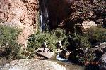 Below the falls the beach was a little higher, and broader than it was last year or the year before. The artificial flood created this past spring had done a reasonably good job in replenishing it.
Day 7. Monday, 9/30/96
Day 8. Tuesday, 10/1/96
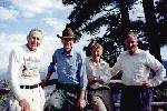
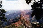
STATISTICS: 1996
(These are estimates, based on my counting paces.)
Mileage: Bill Hall Trailhead to junction with Thunder River Trail . . 2.6 miles Junction to Ranger Rock . . . . . . 1.0 Ranger Rock to 1st Night Campsite (Overhanging Rock) . . 1.5 Campsite to Top of Redwall . . . . . .5 Top of Redwall to Indian Maiden . . . . . 1.25 Indian Maiden to Top of "Y" . . . . . .75 East Arm of "Y" . . . . . . . .35 Junction of East Arm with Cross Valley Trail to Cardiac Tree . 1.25 Cardiac Tree to Thunder Falls Path . . . . .75 Thunder Falls Path to Junction with Tapeats Creek. . . 1.1 Tapeats Creek Junction to Upper Tapeats Campsite . . . .4 Total miles from Bill Hall Trailhead to Upper Tapeats Camp . 11.45 Upper Tapeats Campsite to Upper Ford . . . . .1 Upper Ford to Cliff . . . . . . .6 Cliff to Slanting Rock . . . . . . .75 Slanting Rock to Lower Ford . . . . . .6 Lower Ford to Beach . . . . . . .5 Total miles from Upper Tapeats Campground to Beach . . 2.55 |
If you have any questions, or would like to talk to me more about this trip, contact me at PapaBiker@aol.com or rgroves@surfsouth.com.
|
|
|---|
|
|---|