|
I was up early, before the sun, as I knew I had a lot of miles to cover today. The sky was slightly overcast and I hoped that I wouldn't be having any bad weather. After a quick breakfast I grabbed my daypack, threw in some lunch and some other essentials and headed off up-river. There was really no sign of a trail anywhere so I continued on along the beach and through the tammies and hoped that I would pick it up somewhere at the western end. I never did but after about travelling about 3/4 mile along the beach, through tammies and over boulders I eventually came to a point where I could go no further. A huge block of Vishnu Schist comes right down into the river and allows no access around it, except maybe at really low river levels, which don't occur any more since they built the bloody dam (damn), so... I looked around and found the rockslide that is mentioned in the Sierra Club Totebook, Hiking the Grand Canyon,
and proceeded to climb. It is a long way up this slide and it is pretty steep in some places.
When you come down on the other side you will be at Papago Canyon. I walked up this side canyon a little ways just to see what it was like and it was quite interesting and would probably prove to be an interesting day hike in itself if you have the time. The water that runs (roars) down the canyon during flash floods has sculpted some interesting bowls, alcoves and falls along the floor and walls. I didn't have time to explore it in any great detail so I returned to the beach and continued on up-river and to the west.
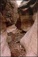
I continued along the beach all the way to Nevills Rapids and the mouth of Seventyfive Mile Canyon and beyond this point there was no beach left to walk on. I headed up into Seventyfive Mile Canyon looking for the ascent that would get me out and allow me to continue west. This turned out to be a lot further down the canyon than I expected and when I found it I was glad that all I had was a day pack because the trail that was marked went almost straight up the canyon wall to some ledges above. The climb really wasn't that high and didn't take that long but all I kept thinking was "What happens if I fall here"? Up a side canyon, a mile or so from the river, in an extremely isolated section of the Canyon. That's enough to keep anyone alert and careful.
The view from the top of the canyon was spectacular and when you finally work your way back out to the river the view of the Nevills Rapids from above is pretty good as well. From here the trail contoured along the top of some ledges before descending to river level again at the mouth of Escalante Creek. I headed up along the beach a little ways hoping I would be able to take the low route here, but no long, I eventually came to point that was impassable. I trudged back up to Escalante Creek and headed up into its side canyon. I had a hell of a time figuring out where the trail went in there. I made it up to where the creek forks into east and west branches and the map said the trail went up along the eastern branch. There were no cairns marking the way and I could see no way up. Damn! I really didn't need this. After some considerable hunting around I found some cairns near the western branch. Oh well, maps have been known to be wrong here and the Escalante isn't a trail after all, only a route.
I followed the trail up along the western branch which it eventually crossed and then headed up along the eastern branch. Success. Not! When I got to the point to where the trail descended into the top of the eastern branch the only cairns to be seen headed back down the creek bed. Oh, well, maybe the trail has been rerouted up here as well. I followed blindly and eventually came to a cliff in the air that looked back down into the floor of the Escalante. Double Damn! I could only conclude that the cairns I had found were marking a section of the old trail that came up the eastern arm.
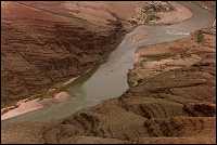
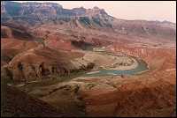
Now for my biggest mistake. Instead of being smart and heading back to where I knew the correct trail would be I decided to take off cross-country and hope to intercept the spot where I thought it would be. I headed up out on the eastern side of the bank and headed towards the river thinking that the trail would be out there somewhere. Wrong! It was nowhere to be seen but the view was awesome. I then headed east hoping to find the trail on the other side of the slope I was on, it had to be over there somewhere. Nope! But I did get another incredible view of the river and the Unkar Creek Delta to the northeast and stopped to take a picture. I then continued on towards the north still hoping to intercept the trail. For some reason I expected it to be below me but it was no where to be seen. During this stretch I noticed a river party coming down through Unkar Creek Rapids so I took out my binoculars and stopped
to watch for a while. The trail had to be higher up and if it was I stood no chance of seeing it from below. I started climbing as I continued to the north and finally found it. I had managed to loose an hour and a half in my wanderings and at this point I knew that it was pretty unlikely that I would make it to Tanner Rapids, especially not if I was going to encounter similar problems on the way back to Hance.
I followed the trail, which was reasonable level along the next mile or more until it started to descend towards the Unkar Creek overlook. Even this was a very gradual descent and I finally reached the overlook around 12:30. It had taken close to 5 hours to get here and there was no way I was going to make it to Tanner Rapids and back to Hance before dark. It was sad because I could see Tanner from the overlook and that section of the trail must have been pretty easy. All I had to do was descend to the river and follow the beach for two miles. Not on this trip. I sat on the edge of the overlook and ate my lunch.
After lunch I started back towards Hance Rapids. I knew it would be a race with time to make it before dark. The trail was clearly marked all the way back to the upper portion of Escalante Creek. How could I have been so stupid!? The trail heading east out of Escalante Creek had gone right up out the other side of the bank from where I had entered it. It was not obvious and there was no cairn marking it but I should at least have looked. I built a cairn on the top of eastern bank and destroyed all those heading down the creek bed. I was determined that others in this situation would not have to make the decision. To this day I don't know if this was someone�s idea of a practical joke or whether the route was just poorly marked. If it was a joke I did not enjoy it!
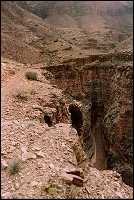
The trail back to down to the floor of Escalante Creek and on to the river was easy and I was making good time. Back at the river I had a little trouble finding the route west. I guess I didn't pay good enough attention so the path I took down to the beach. I finally started climbing up the ledges to the west and found some cairns on the top. The route back to Seventyfive Mile Canyon was easy but the descent down the canyon wall and into the floor still made me a little nervous. Falling here could mean the end, especially with night coming. As I descended the wall a man passed below me heading for the river. No pack, no gear, no nothing and he apparently didn't hear me coming down until I made the final jump to the canyon floor. He looked quite startled when he turned and saw me. We talked for a while as we headed for the river and I discovered that he was with a river party who had camped just below Nevills Rapids. When I got back out to the river it was quite crowded. People and tents and gear were
everywhere. I continued on to the west, it was getting dark and I still had about 2 miles to cover. I made it, but just barely. It was almost dusk as I descended the rock slide near Papago Canyon and it was pretty dark by the time I reached my tent. Luckily the Moon was in its first quarter phase and did shed a little light on that final stretch When I reached my tent I pulled out the stove, made and ate a quick dinner and called it an early night. I was exhausted!
|
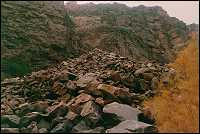
Mountain of boulders to climb on the Escalante Route
|
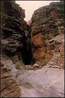
Papago Canyon
|
Papago Canyon
|
Seventy-Five Mile Canyon
|
Seventy-Five Mile
|
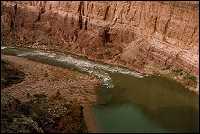
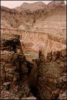
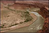
Nevills Rapids
|
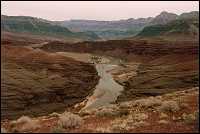
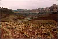
Escalante Route, looking northeast towards Unkar
|
Rafts coming out of Unkar Rapids
|
View west from Unkar overlook, Palisades of the Desert
|
View west from Unkar overlook, Palisades of the Desert
|
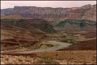
Unkar Creek delta and rapids
|
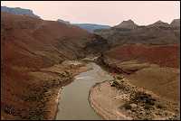
View downriver from Unkar Overlook
|

Unkar Creek delta
|
Unkar Creek area
|
|


