USGS Topo Maps for Grand Canyon National Park |
|---|
| |
|
|
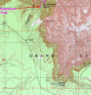 Grandview Point USGS quadrangle [ segment A - A ] |
||
|
|
|
|
| |
|
|
|
 Taken from "Grandview Point" quad of United States Geological Survey (USGS).
A company by the name of TRAILS ILLUSTRATED produces a great backpacking map for the Grand Canyon. Though the TRAILS ILLUSTRATED maps do not contain the same level of detail as the USGS maps they are quite sufficient for backpacking trips and are also a lot more durable than the USGS maps. The entire map that contains the section of the Canyon shown here can be obtained by contacting TRAILS ILLUSTRATED at the address or telephone numbers given below. TRAILS ILLUSTRATED maps are printed on 100% plastic material which is waterproof and tear resistant with normal use. They are perfect for backcountry use. TRAILS ILLUSTRATED publishes over 50 National Park maps as well as maps of Colorado, New Mexico, Alaska and Utah. For additional information, or for a free catalog, contact:
TRAILS ILLUSTRATED
P.O. Box 4357
Evergreen, Colorado 80437
Phone: 800-962-1643 - FAX: 800-626-8676 Click here if you are interested in learning how I did all of this.
|
|
|---|
|
|---|


