|
Seeing the Shaman's Gallery over in Tuckup Canyon is something I have wanted to do for a long time now. Every now and then I would hear stories about it and see photographs of it and each time it always increased that desire to go and see it myself. This year was a trip to primarily seek out some rock out in the Southwest so it finally happened. The first stop on this trip was a hike in the Vermillion Cliffs the day before to see the rock art at Sand Hill Crack. At the end of that hike I headed right for Tuckup Canyon with plans to camp at the Tuckup Trail trailhead that night and start down the Tuckup Trail early the following morning for a day hike to see the pictographs at the Shaman's Gallery.
Probably the hardest part of this trip was driving to the trailhead for the Tuckup Trail. The first part of the drive on Mount Trumbell Road from AZ 389 was easy enough but conditions deteriorated quickly once I turned off of that road. I was very happy that Alamo in Flagstaff gave me a Jeep Compass instead of the Toyota Rav4 that was listed on the reservation confirmation as the Compass had much better clearance than a Rav4 and in places on these roads that was most helpful.
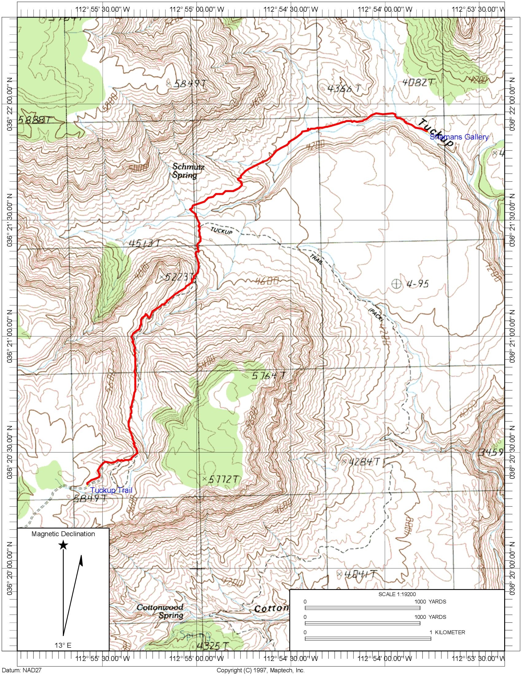
From the turnoff on Mount Trumbell Road to the trailhead was about 17 miles of driving most of which was not too bad but the bad sections were very bad. There had been snow and rain just a couple of days prior and this had created some muddy ruts that had solidified into rock ruts and required some careful driving to get around. The road is incredibly narrow and I had no idea what would happen if I had encountered a vehicle coming the other way as there was no way two vehicles could pass on this road. One vehicle would have to backup to a place to get off of the road and in many sections this would be a long drive backwards on a very bad road. Luckily this didn't happen during the drive in or the drive out. I put the coordinates for the trailhead into my Garmin Nuvi GPS and that took me to within 5 miles of the trailhead before its map lost the road and told me I was "off road". At that point I switched to my Garmin GPSMap 60cx and it managed to navigate the remainder of the roads to the trailhead. There really are only a couple of places where it is possible to turn off of the road and if you follow the road that appears to have the most usage you will end up at the trailhead. When I arrived at the trailhead there were three other vehicles there but no people in sight. There was a Jeep Wrangler there with a flat tire but it had a spare on the back and hopefully that spare was good. There was also a Toyota Rav4 and it must have been a fun ride in on that thing. There was also a full-size SUV that likely had no trouble at all.
I was very happy to have the trailhead to myself for the evening. I hadn't eaten anything for lunch yet so the first thing I did was to make myself a couple of sandwiches. I was planning to just sleep in the back of the jeep so there was really no camp to setup and I did a little hiking around the rim of Tuckup Canyon while waiting for dinner time. It ended up being very windy and I was actually quite happy that I would be sleeping in the jeep and not in a tent. I had a difficult time trying to get my stove out of the wind to boil water for my freeze-dried dinner. I picked up a couple of bottles of beer from the Grand Canyon Brewing Company when I passed through Jacob Lake and I had one of those, the Hop Bomber India Pale Ale, with my mac & cheese for dinner. I enjoyed the other one, the Winter Bourbon Barrel Bomber, a little later while watching the stars come out and waiting for night to fall.
I slept well and was up around 530. It was a chilly morning with the temperature initially only around 37F. I heated some water for my coffee and my granola with blueberries and was very happy to be able to sit inside the jeep to have my breakfast. I was sure I would warm up quickly once I started hiking but I was still happy to have been smart enough to bring gloves and a warm hat with me.
I started down the trail right around 7am. It was a mostly cloudy morning and there really was not a lot of sunshine. There were a few breaks in the clouds and the sun came out a little from time to time but those times were few and far between. There was lots of flowers on the trail but the thing that interested me the most of the abundance of crinoid fossils. There was a stretch of about a half of a mile or more along the trail where they were just everywhere.
As I was heading towards the drainage that leads to the Shaman's Gallery I spotted a person coming up the other way from the other side of the drainage. This confused me a little as I was pretty sure that the Tuckup Trail did not go down there and made a right turn at the bottom of this descent and headed in a more southeasterly direction. The trip reports I had read suggested leaving the trail near a large block of rock, which I could see below me, and hiking along the south side of the drainage to a place where you could climb down to it. Some also said that you could just stay on the Tuckup Trail and then break off and head straight for the Gallery and descend to the creek bed just across from it. I was very happy to meet up with this guy before I attempted any of this. He said that Tuckup Trail had been rerouted and now went down into the creek bed and right past the Shaman's Gallery. This was good as I never saw any place where the trail turned to the right and headed southeast. He also said that going cross-country was a bad idea since there was a lot of cryptobiotic soil out that way and one member of his party had done it and was very sorry of it. He said to just follow the trail to the creek bed and then follow the creek bed to the Gallery and that's what I ended up doing. I ended up meeting the rest of his party a little further down the trail and they confirmed all of this and told me I was about 45 minutes away from the Gallery.
Well, I would have been about 45 minutes away from the Gallery if I had the correct waypoints for it in my GPS but I didn't and the coordinates I had were probably off by about a mile and were much further down the creek. I walked right past the Shaman's Gallery because I thought it was much further down the creek bed and had not even started looking for it yet. When I reached the position I had in my GPS I was very confused because there was nothing there to be found. I kept going until the walls rose up around me and I knew it was just not the right place. There were still footprints in the creek bed ahead of me but if this was the actual trail now that would be expected. I turned around and started working my way back up the creek bed, looking for the Gallery. I saw a couple of places that I thought could be rock art from a distance but they ended up being just cracks in the rock or lichens growing on it.
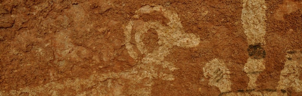
I had almost given up and figured I was not going to find the Gallery when I finally looked up and there it was, much further up the creek bed than I expected. The coordinates I had were guestimates based on some maps I found another trip report and they were way off. I was very glad that I had not attempted the cross-country route or anything else as descending to the creek bed at the coordinates I had would have been a nightmare. It looked possible but it did not look like fun.
The Shaman's Gallery is incredible and was well worth the adventure. As it was I ended up seeing a bit more of Tuckup Canyon that I had planned but it was a very nice day for it. I ended up hiking about 3 more miles than I had planned and what was supposed to be a 6 mile hike ended up being closer to 9. It was about 10am when I finally reached the pictographs and I spent about 20 minutes there studying and photographing them before starting the hike back to the rim. It only took about 2 hours to get back to the trailhead and I got there around 1230 or so. I should have eaten some lunch there but decided to wait until I got to my next stop, the Toroweap Overlook.
On the way back to the main road I was surprised to catch up with the group of guys I had met on the trail as they should have had a several hour head start on me. They were not driving very fast at all though and apparently the Rav4 ended up getting a flat and after changing the tire they decided to really slow it down and take it easy as getting another would be a real problem way out here. They pulled over to let me pass and I continued on to the main road. If I thought the road to the Tuckup Trail was any kind of challenge this was nothing compared to the final few miles of the road to the Torowap Overlook. I has been out there once before about 20 years prior and did not remember anything like what it was. Hair raising would be an understatement but after coming all that way I was not going to be deterred by those last miles. The road was fine up to the Grand Canyon National Park boundary but then started to get worse from that point on. It was still pretty good up to the Tuweep ranger station but beyond that it turned out to be a real nightmare. Rocks, ruts, steep slabs of rock... all at the same time. The Jeep Compass turned out to be a real champion in my mind.
The view was worth it though and I scrambled back and forth along the cliffs for about an hour taking photographs. It was still a cloudy day and I was somewhat disappointed at the lack of sunshine as I know it would have made for better photos but it was still very nice. Considering the condition of the road coming going out there it was unlikely I would ever be going back again.
The ride out was equally as hair raising and I was very happy to be done with it and back on the main road. I was wondering if I would be able to make it to my destination for the night before it got dark and luckily I did. Once I got back on the main road the conditions improved considerably and I was able to do 40 and sometimes 50 mph all the way back to AZ 389. I took the more westerly route out and ended up picking up the highway in Colorado City. From there I continued up into Utah and followed Utah 59 into Hurricane and a motel room for the night. It had been a very exciting day.
This hike is supposed to be about 7 miles roundtrip to the Shaman's Gallery but I ended up walking about a mile or more past it and then the same distance back so for me it was a little more than 9 miles in all. The elevation gain/loss is around 1800'.
| 


