|
I day hiked up to the Sand Hill Crack in the Vermillion Cliffs to see and photograph the petroglyphs up there. I know this isn't "technically" the Grand Canyon but the Vermillion Cliffs are close enough for me and could actually be considered the true north rim. I've always wondered what the view was like from the top of the Vermillion Cliffs and now I do not have to wonder any longer. It's fabulous!
I was looking for some nice day hikes to do in northern Arizona and southern Utah since I was unable to do a longer backpacking trip this spring. I was supposed to do a 9 day backpacking trip at the end of March and into April but a herniated disc in the lower back made that seem a little unwise. A couple of weeks before I was supposed to head out west one of my Grand Canyon buddies posted some information and photos from a hike he had done at Sand Hill Crack and it looked perfect.
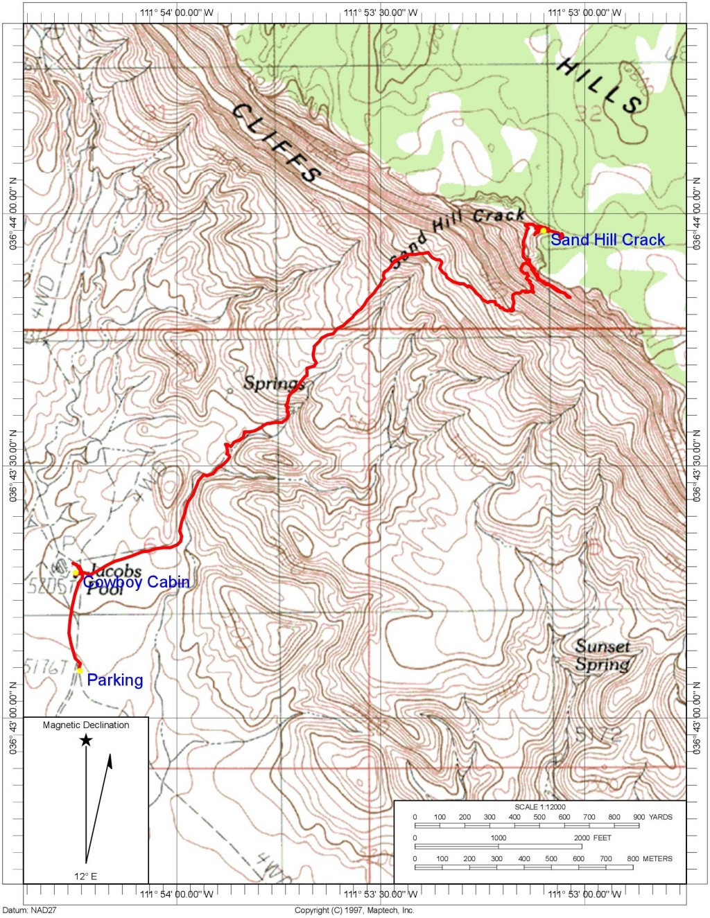
I left our house in Flagstaff a little before 6am and was at the parking area around 8:30. The road going in there leaves US-89A near mile post 557 and has a closed gate across it and a sign just behind that says "Welcome to Vermillion Cliffs National Monument". The road going there in is dirt and a vehicle with fairly good clearance is required. I had a Jeep Compass and that has no problem with the road at all. Not sure you would get in there with a normal auto. It is about a 2 mile drive going in and you are getting close to the trailhead when you spot the old cowboy cabin in the distance. The road crosses a wash a one point that is pretty easy but then comes to a second one with steep sides and a very sandy bottom that I was not willing to risk attempting. It is only a short walk from there to the cabin and the start of the trail and it looks like that is where most people park if they go in there. From that parking area you can just walk the remaining 400 yards or so to the remains of the cabin and the start of the trail.
From the cabin the trail heads off to the north-northeast and it's an old road so sort of hard to miss. After about a quarter mile it turns more northerly and passes between a couple of gray hills. On the other side of these it was not quite so obvious where the trail went to me but it just continues in the same direction, towards the greenery surrounding the spring which you should be able to see directly ahead.
Just before the spring the trail starts up a slope to the left and then continues along that ridge directly toward the crack. Most of the trail in this area is pretty easy to follow but there is also a lot of sand which can make it tough going at times with your foot sliding back about a half a step for each step forward. It's not called Sand Hill Crack for nothing---there is a lot of sand. The trail gets steeper the higher you climb which makes you slide back even more.
Above the first sandy section, which goes on for a little more than a half of a mile, the trail levels out a bit. It turns to the right and heads in a more easterly direction and travels below some small cliffs just above. After a quarter mile or so it turns left and begins to head more north again, up another sandy slope and heading in the general direction of the crack in the upper cliffs with a few meanders here and there.
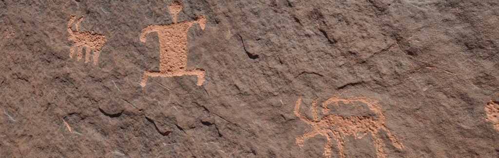
As you approach the crack there will be some cliffs running off to the right/east. I spotted a cross and some graffiti scratched into these near the trail and scout along the base of them for a while looking for actual rock art but didn't fund anything. The real rock art is still a little higher up just before the final climb to the rim. The trail will go right past some on the right but there are some much nicer ones at the base of the cliffs that run off to the left/west. From the rock art it is a very short climb up a steep little gully to the actual rim.
The view all along the trail on the way up is magnificent but nothing compares with the view from the top. There is lots of slick rock sandstone on top that is very cool looking as well.
This hike can be done as a loop by heading west along the top of the cliffs and then descending via another trail/route through another break in the cliffs on that side. It is supposed to be a lot steeper and much less of a trail though marked with cairns in a few places. I really did not like the looks of it from the bottom myself and given the back problems I had been having and the fact that I was alone I decided against it. I really did not want to get all the way over there and maybe even start down and then deiced "mo way" so I just went back down the same way I came up.
The trail I had taken up was very quick to descend and the sandy sections go past really fast on the way down as every step forward seems like covered 2 or 3 steps before your foot comes to a stop.
Total mileage: About 5
Elevation gain: About 1,900'
| 


