|
Trip Report - October, 1996 - Nankoweap |
|---|
Well, to begin with, I must say that this was certainly an interesting trip. It was my first (and possibly also my last) trip down the Nankoweap and cannot say that I really enjoyed the experience. Part of this was my own fault for not heeding the advice of the Park Service trail description for the trail and trying to do too much in too little time. The other fault lies with the trail itself or more specifically with its length, steepness and the amount of exposure to be found along certain sections. I also had problems with some abnormally high temperatures that one would not normally expect during the first week in October.
Before attempting this trail you should try to gather as much information from as many sources as possible and listen to what people tell you. I ignored the information on the steepness given in the Park Service trail description because from what I have seen of most Park Service trail descriptions for other trails, they tend to make the trail sound a lot more difficult than it actually is. This is not the case with the Nankoweap, it is a very steep and very long trail and it has a good many places where a slip can be fatal.
The Park Service trail description also lists a number of campsites on the trail between Marion Point and Tilted Mesa but nowhere do they actually tell you that you should use these. I am telling you to use them. Trying to go all the way from the rim to the river (or even just the creek) in one day is asking for trouble. Apart from the nasty exposed sections in the long traverse in the Supai Formation (which aren't really difficult, just scary) the worst part of the trail, as far as steepness is concerned, comes very near the end when you are descending from Tilted Mesa to Nankoweap Creek. If you are doing the hike in one day then you could be quite tired and sore already by the time you reach this. I took a nice long rest on Tilted Mesa before beginning this section and still had trouble with it.
As a result of my poor planning, and the problems that it caused, I had to cut back on the amount of hiking I had planned to do in the inner canyon, and instead took it fairly easy and let my body recover before attempting the hike out. I was hoping to get over and explore some of the Little Nankoweap area and also take a hike over to Kwagunt Valley and did not have the time or the energy to do either. I left my campsite where the trail joins the creek and spent one day going down to the river and the other day going up the creek away from the river. The area is quite beautiful and serene (in spite of all of the air traffic) and a trip to it should allow for at least a full week to take it all in.
The October 1996 issue of ARIZONA Highways magazine features an article about the Nankoweap Trail entitled Grand Canyon's Scariest Trail. In this article, AZ Highways writer Gail Dudley and Grand Canyon park ranger and photographer Rick Danley tell of an aborted journey down the Nankoweap. The trail proved to be a little too much for Gail, maybe the fact that she had never been hiking in the Canyon before had something to do with this?
Happy Trails
| |
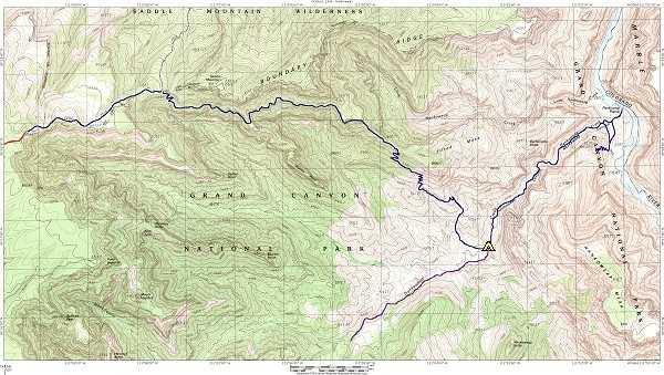
| View larger trail map |
|
|
|
|---|
|
|---|