|
Day 3 - Day hikes up and down Shinumo Creek |
|---|
|
|
|
|
|
Tuesday, October 12, 1999
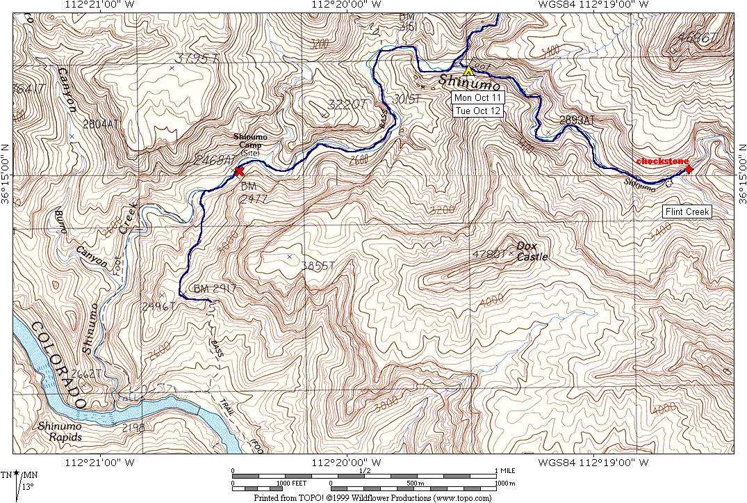
I slept better than I expected I would and felt very rested when I awoke around 5 am. It was still too dark outside to do anything so I just lay around and waited for the dawn to come. I spent some time thinking about the route I was going to take over to the Merlin and Mordred Abysses the following day and kept switching back and forth between the Burro Route as originally planned, which was longer but probably quicker, or the route up Shinumo Creek, which would be shorter, but considerably slower and very wet. I had to put off any final decision until I saw what the upper section of Shinumo Creek looked like but knowing that didn’t stop me from thinking about it. Day 3 dawned clear and beautiful as ever. At least I was having good luck with the weather. I was up around 6 am, had some breakfast and was out of camp at 6:35. The trek down to Shinumo Camp required a number of creek crossings (8-10?) and all but one of these were relatively easy, being aided by rocks that just seemed to be in the right place at the right time. At one point, however, I just had to slosh across the creek and hope for the best. I was glad that I was doing it with just a daypack and not my full load of gear though. All of the rock hopping would not be fun with a full pack. At 7:45 I arrived at Shinumo Camp and took a long rest stop to take some photos and check on my feet. I reapplied some moleskin and band-aids. One of the blisters on my left foot (bottom) had broken and there was now a very raw spot where the skin had come lose. The other blister, on the side of the big toe, still looked pretty nasty. There was nothing much I could do about it and I just put on a fresh band-aid and wrapped some sterile tape around it to hold the band-aid in place. The right foot had developed a blister on the bottom right in the crease of skin between the big and second two, in spite of the moleskin that I had applied late the day before. I guess I was too late. This one was hard to treat because it was long and thin. It didn't really hurt to walk on, unlike the ones on the left foot. I did the best I could and put my boots back on. Note: The artifacts of Shinumo Camp are not located at the actual site, which appears on the topo map at USGS benchmark (BM) 2477. They are actually located under a small overhanging cliff on the south side of the creek about 100 yards upstream of the site. From Shinumo Camp I continued west and then south to the Colorado River overlook on the North Bass Trail. I left Shinumo Camp at 8:15 and was at the overlook at 8:35. This section of trail was very nice and I figured that it was probably maintained by river parties to provide access to Shinumo Camp. I decided to save myself some time, and my feet some pain, and did not descend to the river, but rather turned around and headed back to Shinumo Camp and then my own camp. On the way back down I had some really nice views of Spencer Terrace and Fiske Butte across the river, and began recollecting the hike that I had done over there in the spring of 1998. At 9:05 I passed back through Shinumo Camp and at 10:20 was back at my own campsite. There were still numerous crossings of Shinumo Creek on the way back but not as many as on the way down. There seemed to be more "trail" on the south side of the creek on the way back so I stuck with it as long as I could. There appear to be numerous routes crossing and re-crossing the creek and you just need to pick the one that's easiest depending on the water level. I rested at camp for about an hour before heading off on the second day hike, upstream along Shinumo Creek to its confluence with Flint Creek. I left camp at 11:30 and arrived at the chockstone just past Flint Creek at 12:40. The upstream hike along the creek was a lot more difficult than the downstream hike that I did earlier in the day. The creek seemed more confined along much of this stretch which had it running deeper. It also required many more creek crossings and scouting out the correct place to cross with the proper arrangement of rocks was time consuming. This was definitely a hike to be done in Tevas, which I did not have with me. There were also a couple of places where you had to scramble along the cliffs next to the creek. There would be no way that I would want to do this with a full and heavy pack and the decision was made that I would hike back up the North Bass Trail and use the Burro Route to get over to the Merlin and Mordred Abysses. I also did not see how I was supposed to get around this chockstone with the amount of water that was coming down the creek. I knew that there was a bypass route on the right (south) side of the creek but I did not like the looks of that either. I was hoping that most of this water was coming all the way down Shinumo and that Mordred would be more like White Creek had been. At one point on my way back to camp I dropped my hiking pole while rock-hopping across the creek and the creek proceeded to carry it away... down, down, down to the Colorado. I knew that I would not fare well without it and quickly started scrambling along the bank of the creek in hopes of recovering it. I was surprised that it was moving as fast as it was, considering that it was metal, very long and had a strap dangling from one end. This water was really moving and I knew that if I didn't catch it before the next time I had to cross the creek that it would be gone for good. It went over a small fall, stood upright briefly and then flipped over and continued down the creek. Standing on end as it did for a time gave me second or two to catch up with it and I dived to grab for it as fell back into the creek. Big mistake! Oh, I got the hiking pole all right, but I also smashed my left knee into a rock in the process and it was bleeding. It didn't hurt but then I hadn't tried to get up on it yet. When I did finally put wright on it, it hurt and hurt a lot. I felt around the kneecap and everything seemed to be in place and the bruise did not seem that deep, only the top layer of skin had been scraped off, so I didn't think anything was broken. Still it hurt to put my full body weight on it and so I used the hiking stick as a crutch and hobbled back to camp. I returned to camp at 2:00 and by that time the pain in the knee had been reduced to a dull throb so I figured I had come out of the experience very well off. There was no swelling and now it only hurt when I had to put all of my body weight on the left knee, as when stepping up on a large rock. I, of course, started favoring the right knee under these circumstances and when I forgot the left knee sent me a sharp message of reminder. I did nothing else for the remainder of that day except read my book, and move from one shady spot to another as the afternoon progressed and the sun moved across the sky. The knee did not bother me at all when I didn't use it and when just sitting around there was no pain at all. I hoped by taking it easy that it would heal up completely by the next day. I had an early supper that night and retired to the tent early as well, reading as much as I could before losing daylight, and for a while after by the beam of my flashlight. |
|
|
|
|
|
|
|---|
|
|---|


