Hiking Log 20: Deer Creek Canyon
Mileage: About 7.5
Elevation Loss & Gain: About 1866'
Buttkicking Factor: Easy peasy, with a few rough areas and some queasy dropoffs. 2.5
One of the really cool aspects of this hike is that I did nearly the same one when I was 29 and living in the Grand Canyon. I was part of a river work trip and we pulled up to camp across the Colorado from Deer Creek. After relaxing for a while, I overheard two of the fabulous boatgrrls talking about doing a hike. It turns out they had deliberately left a raft up at Tapeats and were going to hike up Deer Creek, across Surprise Valley to Thunder Springs, flirt with the trail crew they knew were working there, and then down Tapeats to pick the raft up. (And then bomb the rapids in a way they were avoiding with passengers, but I didn't know that then.) I asked if I could come along--it sounded like awesome fun. They said yes, so off we went.
I've discovered when you return to a place that you've been to once or twice in your life, it's very easy to flash back to certain memories and impressions. When I was approaching Thunder Springs, I remember detouring onto the upper campsite, where the trail crew had left their gear, and watching the two women (Nicole and Willow) leave silly messages for their friends. They were using rocks to spell out words. Likewise, coming up from Deer Creek, I remember watching Willow scrambling over the rock field, placing her feet just *so* for maximum efficiency. (This is how it's easy to spot an accomplished hiker. There's very little wasted motion when going over a tricky trail, and it's done very unconsciously.) For a few minutes every now and then, I was brought back to being in my 20s and a NPS employee.
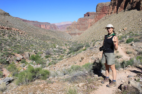
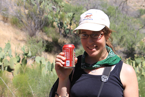
Francie and I had gotten up at 4 am for two days straight by this point, so we didn't give a crap if it was going to be a million degrees out: we were going to sleep in and be damned with it. Still, the tent heated up quickly as soon as the sun touched it, so I was up around 7:30 am. Francie soon followed, and we were off across Surprise Valley in the opposite direction as the day before.
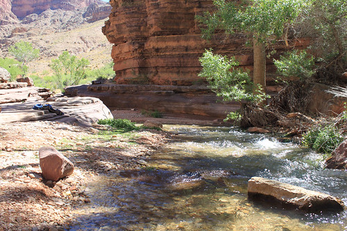
All's well at the approach to the Deer Creek drainage!
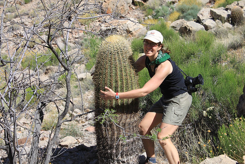
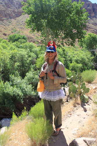
Francie likes to hug things, so I told her that she should hug the cactus.
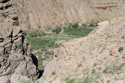
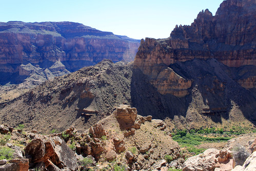
The hike down went quickly and was lovely. It was steep in some places, but neither of us are particularly bothered by heights. This was good, because as the drainage opened up into the canyon vista, it was pretty amazing.
Deer Creek in sight!
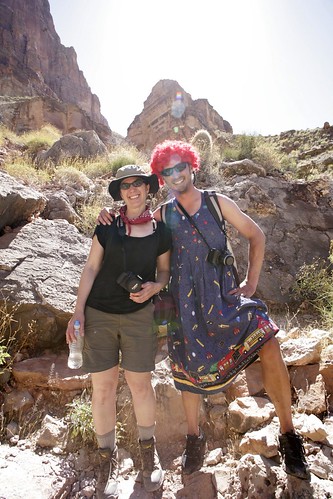
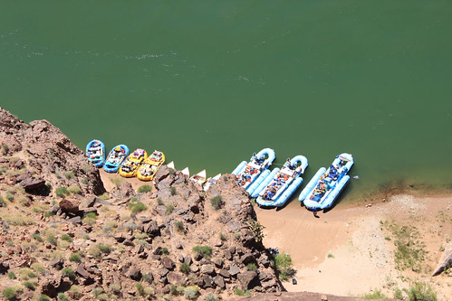
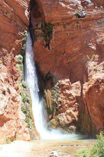
We heard, then caught sight of, Deer Springs, which is a lovely little waterfall about 1.5 miles up from the Colorado. We were heading for it, when a number of people passed us: commercial river runners. There are many, many river trips that head down the Colorado and pretty much all of them stop at Deer Creek. (This is not a place to go if you demand solitude, because you won't get it.) We decided to leave the waterfall for later and continued on down to the actual creek bed. Moments later, we ran into Raggedy Ann(dy).
That wig must have been hot! He was one of the river guides, bent on entertaining his charges. Heh. Later, another guide mourned that their group talked about "nothing but money." I wonder what they thought of a bunch of faux transvestite guides. I thought they were adorable.
We soon hit the riparian zone: native willows (yay!), grasses, prickly pear, cottonwood trees, etc. Back when I worked here, the willows were being severely threatened by the tamarisk. We were in a quandary, because some of the native birds had begun nesting in the tamarisk, so what to do? I didn't see much tamarisk, which is amazing due to its invasiveness, so I guess the eradication continues. Shortly afterward, we hit another river runner (in a tutu and devil's horns), who GAVE US COLD BEER!
Seriously, he pulled them out of individual insulation sleeves from his pack. Said he always brings beer along for hikers. (!!) It tasted so
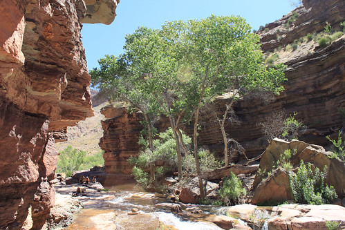
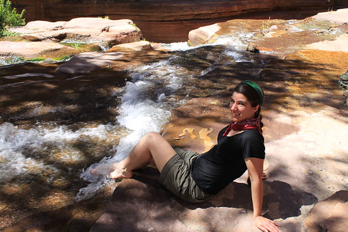
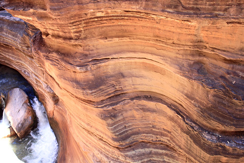
so good to have ice cold ANYTHING. We drank them pretty fast and therefore entered the mouth of the slot canyon a little on the tipsy side. That didn't matter, as we wanted to spent some serious time chilling with a good siesta at the slickrock pools. This area is the best part of Deer Creek.
Looking back the way we came -
Resting -
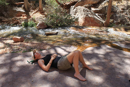
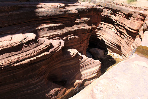
Francie fell asleep, but after a while, I was ready to go through the slot canyon. It's a pretty quick walk, so I nudged her and let her know I'd go through, but come back and get her before I climbed down to the Colorado. She knew one reason I'd come here was that I wanted to photograph the pictographs, so she happily snoozed while I went on my mission.
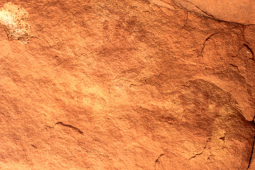
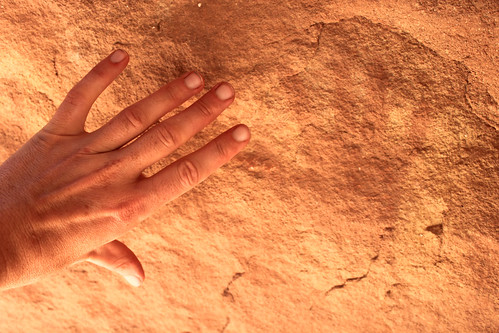
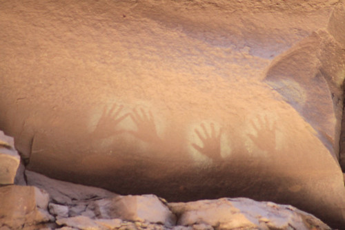
The pictographs probably originally covered many of the walls of the canyon, but time and abuse (people unable to resist touching them) has faded them significantly. I remember them being more visible and numerous even ten years ago. That said, ancient natives have lived in the canyon for upwards of 10,000 years. These pictographs are likely 800+ years old, left by the ancient Pueblo people (aka Anasazi, but that name is falling out of usage). They simply won't last forever. Being in the very protected slot canyon is the only reason they are still visible at all. They aren't chiseled out of rock like petroglyphs, but are made by apply pigment to the rock. Mud blown through straws is the method I hear of the most, but that would seem to work more on negative space shapes, and these are actual handprints.
I didn't touch any of the handprints, but have my hand up for scale close to them.
These last ones are far more vibrant and preserved than any of the others -- and they're across the creek in the slot canyon, halfway up a very inaccessible cliff! God only knows how they managed it. I'm picturing teenage Pueblo boys showing up everyone else. :D
I eventually worked my way through the canyon to the river vista, then returned and woke up Francie. We repeated the trip and came out for her first view of the Colorado river.
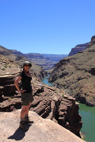
Commercial river runners down below -
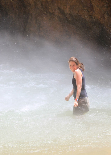
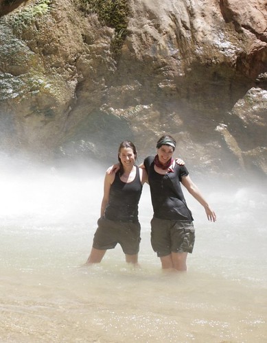
Francie asked me if I wanted to hike down--of course! We not only MUST touch the river, but the best part of the hike still remained. As soon as we climbed the trail down to river-level, we saw it: the falls. Tall, ice cold, beautiful, thundering, spray-filled falls. It didn't take us long to start playing in the water.
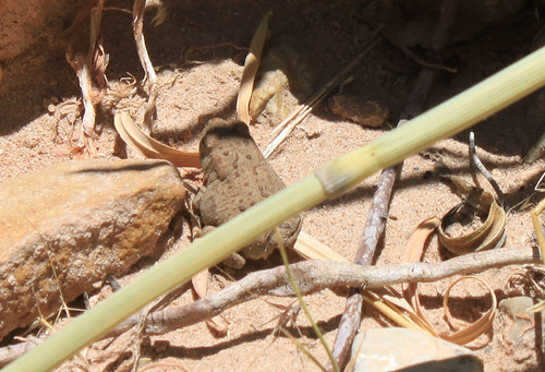
After quite a long time (we're spending the entire day here, remember), we retired to go look at the Colorado. Francie chose a large rock and took another siesta. I joined her for a while, but it got too hot for me quickly, so I went exploring. Found a frog and some tadpoles, a ladybug, and a few other interesting critters.
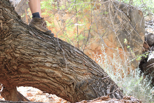
Eventually, the heat by the river got to be too much, so we decided to retire back into the riparian area, under the cool shade of the cottonwood trees. We cooked lunch and climbed trees, and Francie picked up the only injury of the trip by being stung by a fire ant.
About 4:00, we decided to slowly start heading back. We tanked up on water, but didn't refill our bags yet. This is the trick of dry-camp camping. We needed to haul enough water with us to carry us through the hike up, dinner, breakfast AND the entire hike out to the rim the next day. Ugh. There was no water near our Surprise Valley camp at all--the closest was Thunder Springs. So, we stopped at Deer Spring, tanked up again, and loaded ourselves down with water. (We didn't bother to purify here. This is very clean, pure water with no giardia. It was also nice to tank up without having that electrolyte taste, although we dumped the pills into our non-cooking water for the hike up. Electrolytes make the difference between success and failure on hikes like this. Plain water is just not good enough.)
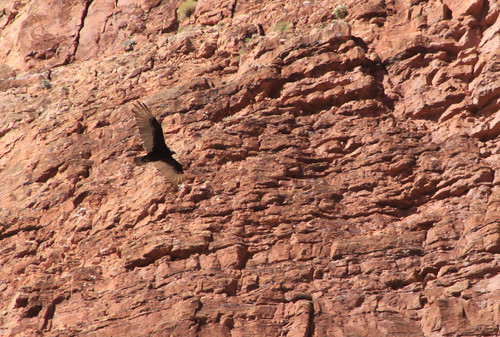
On the way up, I spotted this predatory bird. Not a condor, surely? It's wing markings are opposite the famous California Condors. Some type of vulture?
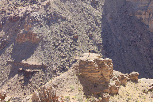
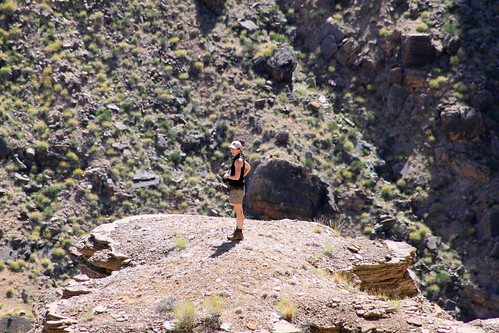
And then, I spotted a close-looking knoll and said, "Hey Francie, you should go climb that!" I wasn't expecting her to, but she did.
Can you spot her?
Telephoto shots:
She eventually returned and the climb up the drainage was really nice. Not too hot, not too hard. We got back up to the Surprise Valley plateau in about an hour and a half. It was too hot and sunny to hang out at camp, so after a break in the only shade we could find, I suggested hiking down the washes. We eventually found a lovely boulder and climbed on top of it. There, we had a beautiful breeze, so stayed there chatting until we were ready to climb down and go make our evening cheesy noodles.
Francie collapsed as soon as it cooled off. I stayed up to watch the sunset and the appearance of the stars, then crawled into the tent. Up early the next day for hiking out of the canyon!