|
TRIP REPORT: S. KAIBAB, N. KAIBAB, CLEAR CREEK, BRAHMA-DEVA ROUTE, N. KAIBAB CROSS CANYON TRIP |
|---|
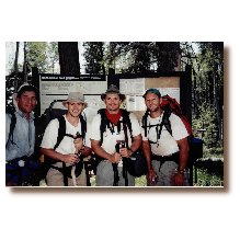
Trail hiking in the GC is very challenging to say the least, but after a solo hike of the Hermit-Boucher loop in a day and a half, and, hiking nearly all the S. Rim trails in 2 years, I wanted to experience the N. Rim. My interest in the Clear Creek area began from reading several trip reports on the Clear Creek trail and the access it brings to Obi Canyon and Cheyava Falls. I became enthralled with this area of the canyon. As I studied my topo maps of the area, my eyes caught what appeared to be a “route” that I thought could be passable between Clear Creek camp and the N. Kaibab trail at Ribbon Falls spur. Not having been “off-trail” before in the canyon; attempting this route seemed to have all the trip features I was looking for…physically stressful, wrought with off-trail problem solving while penetrating areas of the canyon that relatively few had reached before. As I began to research this possible route, I learned from the BRO that a route does exist in this area that has been documented and the BRO could provide me with a route description. Additionally, Butchart has accomplished parts or all this route and has written about it in his books which were very helpful in route study. I also discussed the route with Backcountry Ranger Bil Vandergraff, who lent some good insights into this route. I guess it was my Air Force Combat Survival Training that impressed upon me how route study will save you from error, both minor or mortal. I studied all the charts I could find depicting this area of GC. Usually up late researching and looking at the maps…I got to where I was dreaming in 80’ contour lines and terrain shading. I even studied the satellite imagery of Brahma-Deva from Terraserver.com. It all paid off. More on that later. The six of us, Will, Eddie, Al, me, Phil and Charlie [photo 1] began this hike on 6/8/99. We came together in the Phoenix AP and made the trek to Tusayan to drop gear and then two of us proceeded to the North Rim to drop a vehicle at the N. Kaibab trailhead for our return after completing this trip. We hadn’t even started our hike when the “lessons learned” began posting…. LESSON #1-If you ever attempt to leave a vehicle at the N Rim allow 9 hrs for this trip. I thought Charlie and I could drive it in six…it cost me and driving partner several hours of valuable rest before embarking on this trip. LESSON#2-Always bring the entire group together before beginning the hike to review all equipment, ensure enough safety equip, canteens, eliminate pack item redundancy. We didn’t do this because of our delayed return from the N Rim and it could’ve cost us.
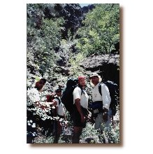
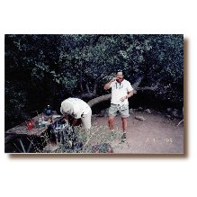
The plan was to leave the Holiday Inn at 5:30am so we could make the early bus to Yaki Point and start down the S. Kaibab. I got up at 5am to call the other guys to let them know that Charlie and I needed one more hour. We got off a little behind but no freat, we had some flex built into the schedule…we wanted to get as far East on the Clear Creek Trail as we could on the first day. This trip was designed so that the most difficult days would be day 1-as much as 15 miles; and day three-off trail approx 7 miles. I counted this group down for six months by sending emails on keeping their training regimen stoked so they arrive at the canyon in top physical shape for this challenging course. It was apparent early in our trip that four out of six of us had been religously training. We weren’t an hour into the descent down the S Kaibab when calls from the rear of our “column” came requesting to slow the pace. We made the obligatory stops at Cedar Ridge and what I call the Photo Op Rock about 15 min past Cedar Ridge. [photo 2] Besides joke telling, most of the S Kaibab conversation was on the same topic…The Asian tourist at the trailhead that began climbing down the rim about 20 feet West of the trail!!! This guy was the quintessential clueless tourist, challenged by the obvious. We called out to him and he realized the error in his way. We didn’t wish him any harm but all of us felt he would likely return to the rim wearing something different than what he started with…a body bag. Maybe he’d be saved by a ranger. This would become a reality for one in our party. Barely more than one hour from the rim, we were sitting around the Tonto East signpost checking our feet. Me stopping 30 min before and removing my shoe to apply some moleskin was a good reminder to the rest of the group to be vigilant to any signs of a blister and to react immediately. A quick snack and we were enroute to the Tip-off to snap a few more pictures and continue. As we began down thru the Tapeats past the Tip-off the winds whipped up to a strong gale and everyone was forced to carry their headgear. [photo 3] The winds continued to be strong thruout the inner gorge. At 3 hr point we were on the Kaibab suspension bridge being rocked by the wind. We were greeted at the Bright Angel Campground by the shaded thermometer on the camp bulletin board reading 100 degrees. We dropped gear in an open campsite in Bright Angel Campground and proceeded with lunch, creek sitting, water replenishment and siestas for the next two hours. Reconstitution was the objective…by 3:30pm we were underway again. Unfortunately, the first mile or more of the Clear Creek Trail has Western exposure. Lack of shade made this part of the hike punishing. Charlie began cramping up with about 1000 vertical feet to go before emerging out on the plateau East of Sumner Butte. With the help of my walking poles and some electrolyte drink, he slowly progressed to the East. We camped in a sandy wash on the W side of the first major drainage past Sumner. [photo 4] Phil and Eddie were quite pleased with themselves after finding this campsite. It was a good site, but my recommendation to other hikers would be to continue on the trail a few hundred yards further where you’ll find a shelf that provides shelter [photo 5] with nearby water-bowls carved in the rock. These waterbowls were full when we were there. Eddie and Al assumed the role of camp gourmet with old family recipes. I think everyone was so aware of their pack weight that the only food we would eat is that which we were carrying our person. It had been a full day and everyone retired early. A couple of “slashes” on my flask and the lights were out.
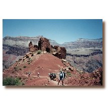
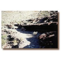
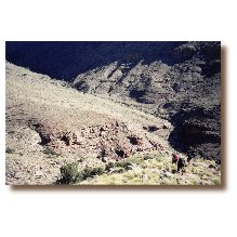
Charlie left camp ahead of us due to his cramping the day before. He departed camp at about 6:15. The trail ahead should be easy to follow but he wanted to begin with a slow pace. I was ready by 7:00 and decided to leave and take video of the others breaking camp [photo 6] (I carried a 5 lb palm-corder camera to chronicle this trek.) Will caught up to me while I was taping. He and I continued with Charlie somewhere ahead and the others about 10 min behind. About 15 minutes after crossing a side drainage where the trail was difficult to find on the far side of the creekbed, we found Charlie about 200 yards North of the trail, paralleling us and looking for the trail. It was worth a laugh! We reassembled on the Tonto-like plateau about an hour from Clear Creek. Will and Charlie went ahead of us while we took a shade break (take it when you can get it on a June GC hike!) Realizing that we had arrived at the final turn in the trail above Clear Creek, I went back to mark the beginning of our off trail route. It would begin the following day. It is somewhat intuitive where to begin the Brahma-Deva route as described by Butchart. After the route study I had done, I recognized the start of BD when we walked up on it. The “so called” game trail to follow to begin the BD Rte starts where the CC turns East and begins switchbacks down into the creekbed. The Clear Creek trail was not difficult descending to the creek but it was loose. [photo 7] Exercising caution with slow and steady pace is what it takes. The Clear Creek trail drops into a side drainage approx 200 yds from converging with actual Clear Creek. We selected a short but broad canopied cottonwood tree as our camp near the intersection of these two “washes” and were setting up camp at 11 am., despite the “protest” and “attacks” from a well-fed tree squirrel. Once water supplies were restored, only Eddie and I opted to day-hike up to Obi and over to Cheyava. The others wanted to lounge about in camp and reconstitute themselves for Day 3 off trail segment. The day hike to Obi Canyon was simple and straight forward. Locating the Anasazi ruins was equally simple…ruins on the west side of the intersection of Obi Canyon and Clear Creek. The ruins are on a ledge maybe 30’ above creek level. As I stood on the shelf next to the ruins, I was impressed by a paternal spirit of a by-gone resident…the thoughts I had were of the pride the former residents of this dwelling had…standing exactly where I was now, some 1000 years earlier, looking over their cultivated fields on both sides of the creek below. Eddie and I continued up the bed of Clear Creek (dry beyond Obi) to see if there might be a wet spot on the redwall at Cheyava. After a mile or so we sat down to take a drink and reverse course-no wetspots in view. As we were sitting there in the creekbed, I saw Eddie look down and mumble, “what’s this?” Eddie reached down between rounded river rocks and pulled up a NY state driver’s license. I think it expired in ’90 so it had probably been down there 10 years. Eddie was going to lookup the individual who lost the license…that shouldn’t be too difficult, Eddie is a Dallas cop. We got back to camp in the late afternoon and looked for a spot to climb into the creek. About a hundred yards down creek we found a natural whirlpool. At this point an “SUV” sized boulder had rolled into the creek and diverted the flow around it creating a basin on the back side large enough for one person (and a few small frogs that called it home). I would submit that this spot has seen more hiker-butt than the benches around Phantom Ranch.
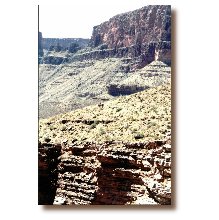
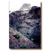
Again, Charlie and Will went ahead of us this morning to climb out of the Clear Creek area and we’d all rally at the shady shelf about 100 yards short of the turn where the trail [photo 8] turns South; we would head North on the “game trail” that climbs about 100 rocky feet above the CC trail. This minor climb up the ridge following the “game trail” looked like the ideal spot for an encounter with a snake-you’re leaning into rocky expanse as you scramble to the top. We were all very cautious and tried to stay in each others tracks. Once we all got on top of what looked like a serpent’s xanadu, we rallied and picked out some aim points that all of us would be using as we proceeded up the NW arm of the Clear Creek (this leads to the Brahma-Deva saddle). Our plan was to “contour and drop” our way up this arm until we converge with the creek bed [photo 9] . Then work up the creek bed to the head of the canyon where we turn West into a small revetment that looks like a “parrot’s beak” pointing South on the map. LESSON #3-nothing is easy off trail in the GC. Mileage comes with much higher exertion. Constant feeding is more important in this phase of the trip. We converged with the creekbed about 2 miles up this arm. A mile and a couple of pour-offs later and we were at the beginning of the “parrot’s beak” [photo 10] ready to begin the climb to the BD saddle. This “parrots beak,” according to the literature from the BRO and Butchart’s book, has several “chalk-stones” in this narrow gully that require climbing under or behind thru narrow crawl-spaces. Let me be a little more specific regarding this gully we called the “parrot’s beak.” There are more like 15 giant chalk-stones in this gully, each requiring a different approach-all requiring pack handling, scrambling and minor rope work [photo 11] [photo 12]. At the chalk-stone with the crawlspace that leads behind it, only Phil could fit thru it. The rest of us had to scale the front side of the stone and assist each other up. Once we broke-out on top of the “parrot’s beak” Al began to complain about not feeling well and group morale began to breakdown--at the top of the “beak” we were standing in very loose scree that had come off the NE side of Brahma. There was no comfortable or secure place to sit and, while the saddle was visible and only a couple hundred vertical feet above us, it looked to be miles away. Turning back was mentioned by Eddie who seemed to be the most discouraged at this point, but not seriously considered. We picked out some aim points and continued to the saddle. The BD saddle is surprisingly flat and runs North/South as a natural bridge between Brahma and Deva. It looks like a short runway, with uniform width of about 50’. We reached the South end of the saddle on the shelf 25’ below it. Our group began to splinter a little more. Charlie, who had been voicing frustration on how close we had been hiking to the edge, wanted to walk to the North end of the saddle so we wouldn’t have to scale the 25’ wall up to the top of the saddle(I thought this to be a minor concern considering what we had just conquered coming up the “parrot’s beak”). I knew we were at least 2hrs behind at this point and wasn’t interested in falling further behind by walking an unnecessary distance. It was mid to late afternoon and I noticed a substantial break in the saddle’s shadow nearby . That break could make for an easy scramble up this wall! I had everyone stop and wait to see if the climb to the saddle could be safely accomplished here. It was easy--that was the good news, the bad news was that as Al got to the top of the saddle he began to dry-heave. We sat on the Southern end of the BD saddle in the shade of Cedar tree assessing what we were up against. I had everyone pull out their water-Al was out, I’m not sure how long he’d been without. We rationed water to provide Al with more. (LESSON#4-Thoroughly check all members water supply before critical phases of your trip to ensure max water supply is carried. ) I’m not sure how much he had when we began that morning. Additionally, I proposed we divide Al’s pack contents among the other 5 of us to reduce his load-he wouldn’t let us do that. Will and I walked the length of the saddle inspecting the terrain below us that we were about to become intimate with while the others rested in the rare and valuable shade. We came to group decision to stay as far from the edge as possible, hopeful that Al ‘s condition would improve along the way down. Al “hung-tough” pushing on. We emphasized to him that at any moment, if he feels faint/light headed, to “hit the deck.” Will led us down from the saddle while I hiked near Al…just in case he were to suddenly lose orientation or consciousness. The next milestone in the BD Route is the minor saddle approx 1000’ to the NW of the BD saddle. That was easy. The next steps were the most difficult-picking our way down the Supai layer and then thru the Redwall. We dropped gear on the minor saddle and dispatched Will to the right and Phil to the left to look for an apparent course thru the Supai and further, thru the redwall. I knew that the literature directed us to the right so when they both returned with observations of “no possibility” I went to the right to look myself. After walking along a shelf no wider than 20” I found a route down to the redwall. It required lots of pack handling and a short 20’ rope descent. I returned where the others were resting. Al was still coherent but still heaving occasionally. The water and gatorade we rationed his way wasn’t helping. He felt well enough to proceed so off we went to find our way thru the supai. It went as I had envisioned-we were thru the supai and looking for the break in the redwall in quick time. That was good; but Al began a more violent and loud dry heaving now-that was bad. Additionally, we were about 45 minutes from darkness. The last thing I wanted was to get us caught in a very vulnerable position descending the redwall in the dark. As we were breaking, looking down on the Bright Angel Creek and N Kaibab trail (our destination) Al took another turn for the worse…Now he’s faint and begins wretching every thirty minutes. It was very apparent at this point his condition would not improve-he had pushed himself with incredible courage but no further could he go (and we weren’t gonna carry him!!!). We had to get him air evac’d! We decided to camp on the ledge above the redwall on a well exposed point. At first light we’d dispatch two guys that feel the best to find their way down the redwall, get to Cottonwood and get immediate ranger assistance. We had, maybe, a pint of water at this point for six guys. With direct line-of-sight to the N. Kaibab trail(only 1.5mile away), Will’s idea of starting a controlled signal fire made a lot of sense. We were preparing a fire on the most visible point to the trail below when we saw lights on the North Rim. It was an incredible relief because I KNEW we could get a message to anyone that would look our direction with my ability to signal. I tried to give Al and the group the same feel of relief that had swept over me but I probably didn’t sound too reassuring, I was rather hoarse from only wetting my lips for the past several hours to conserve water. Will started a small fire with my camp stove while I surveyed all the flashlites the group carried to select the best one for signaling the rim. Fortunately, we had a Maglite with adjustable beam in a backpack(I think there is a lesson here too!). I choked down the beam width and began signaling sequences of three flashes to the lights on the rim. I turned the flashing assignment over to Charlie while I composed several morse code messages that stated we were “6 HIKR, 1 HE, BD RTE, NO H2O.” After about 45 minutes of flashing, we received return signals but no message. Regardless, it was an incredible boost. To eliminate any skepticism, I planned on waking before sunrise the next morning to begin signaling once more to insure we got our messages thru and help would be sent. Not sure when to expect help, I had everyone save urine to use in a solar still I would build in the morning. I was preparing the group for the worst case…no help for 24 hours. Very little sleep was had by anyone that night-Al was dry-heaving about every 30 minutes and had several incoherent sessions of calling aloud for water and help.
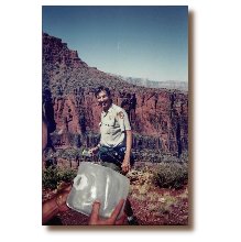
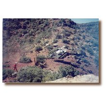
I got up and began signaling the same messages again at around 5:30am. This time, after 20 minutes, I decoded this message from the rim: “WE COP(y)”. Later, we dispatched two, Phil and Eddie, to look for the redwall break and get down to the creek and contact rangers. We weren’t going to sit back and wait. Will and I hoisted a blue ground cloth into a tree to flag our position to anyone looking. Afterward, Will began peeling prickly pear cactus for us to eat. It was very refreshing and full of moisture-but sometimes you’d get a small spine in your tongue! (another Lesson) Al tried getting up but was very light headed and went back to lay down under a blanket. I was digging a second solar still when I heard it--chopper blades spanking the air. The second I heard the helicopter, I ran up to Al and pulled the solar blanket off of him and began my best impression of “el Matador.” The chopper was overflying the BD route; he came right over the BD saddle then flew over our position-looking for an LZ. Nothing near us appeared adequate to the chopper crew. They found suitable spot about a mile to the NW, outside our view, at our elevation where the redwall turns North to Wall Creek. Just a few minutes later we could hear voices coming from the direction where we last saw the chopper. We saw two hikers coming toward us, then two more. Thru binoculars we confirmed the latter two were Phil and Eddie. Ranger Brian Wisher and a SAR Medic (I think his name was Ken Phillips) made great time reaching the four of us and went right to work on Al. They brought a couple gallons of water and several bottles of gatorade with them. After taking Al’s vitals, they stuck him with an IV and got him hydrated in about 45 minutes. During the time they were rehydrating Al, Ranger Wisher and I were talking about our route. Ranger Wisher had hiked this route a couple of times and gave us some direction as to where to get thru the redwall. Once Al was feeling better, we cleaned up our campsite and walked over to the LZ. The chopper was off responding to other crises around the canyon. Charlie volunteered to go to the rim with Al and ultimately, return him to Phoenix after he is discharged from the S Rim clinic. The real hero of this trip was Ranger Wisher [photo 13] -He clearly empathized with us; always upbeat and supportive, he assisted our decision making but didn’t make our decisions for us. He authorized changes to our permit and gave us special directions so that we could roll-over our N Rim lodge reservations to the next nite. His depth of knowledge of the canyon was impressive as he volunteered geologic and anthropologic facts to fill our dead time waiting for the chopper’s return to pick-up Al and Charlie. All of us gained a profound admiration for the rescue crew, but particularly, Ranger Wisher. After returning, [photo 14] the chopper taxi’d both Al and Charlie to the S Rim. Will, Eddie, Phil and I continued, reaching Cottonwood by lunch. [photo 15] Will and I laid around camp while Eddie and Phil hiked down to Ribbon Falls. The remainder of the day was dedicated to thanksgiving and reconstitution.
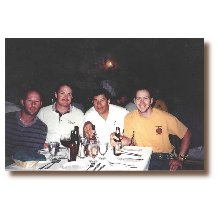
We broke camp early with Will leaving at 6:30 and Phil, Eddie and I leaving at 7:00. From Cottonwood the climbout is approx 5m feet in 7 miles. I had planned to do the first two miles going up to Roaring Springs campground with just a water bottle. But after the experience I had on the BD route I was not going without a full canteen and water bottle! We were nearing the trailhead when we came upon Will. He had been there waiting for us. The hours he spent training on the stair-climber really paid off! (Big Lesson here!!!) All four of us walked out together just before noon. [photo 16] We scarfed pizza and strombolis at the N Rim lodge minutes later. As it turned out, our signals two nites earlier were observed at the Lodge on the N Rim and numerous patrons and employees had some involvement in contacting rangers to alert them. We returned to the lodge for dining reservations and to meet all the people we could that had been involved with acting on our distress signals. We discovered that a N Rim ranger was called over once the mgr of the lodge was advised that flashing signals were observed by lodge workers and guests. Another ranger was there the morning I signaled the rim and he sent us the “We Copy” message. The guests and employees were all very surprised to see and hear us as we told and retold our story and thanked them for taking the time to get involved by calling the rangers. Beer will never taste as good as it did on the N Rim lodge patio that evening! [photo 17] PD |
![Will, Eddie, Al, Paul [me], Phil and Charlie](../pd99/tphoto01.jpg)
Will, Eddie, Al, Paul [me], Phil and Charlie | ||||||
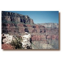
Photo Op Rock near Cedar Ridge | |||||||
Down thru the Tapeats past the Tip-off | |||||||
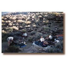
Camped in a sandy wash | |||||||
A shelf that provides shelter | |||||||
Breaking camp | |||||||
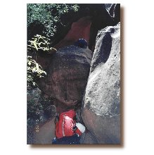
Clear Creek trail descending to the creek | |||||||
![Turn where the [Clear Creek] trail turns South](../pd99/tphoto08.jpg)
Turn where the [Clear Creek] trail turns South | |||||||
"Contour and drop" until we converge with the creek bed | |||||||
At the beginning of the “parrot’s beak” | |||||||
Pack handling, scrambling and minor rope work | |||||||
Pack handling, scrambling and minor rope work | |||||||
Ranger Wisher | |||||||
NPS chopper | |||||||
Lunch cleanup at Cottonwood | |||||||
Arrival at North Kaibab trailhead | |||||||
Beer will never taste as good |
|
|
|---|
|
|---|