|
Trip Report - May, 1999 - Nankoweap to Phantom trip |
|---|
May, 1999
|
|
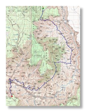
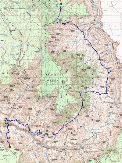
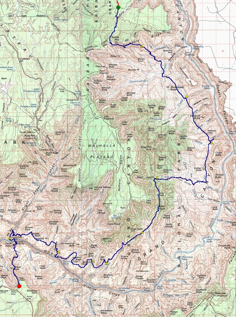
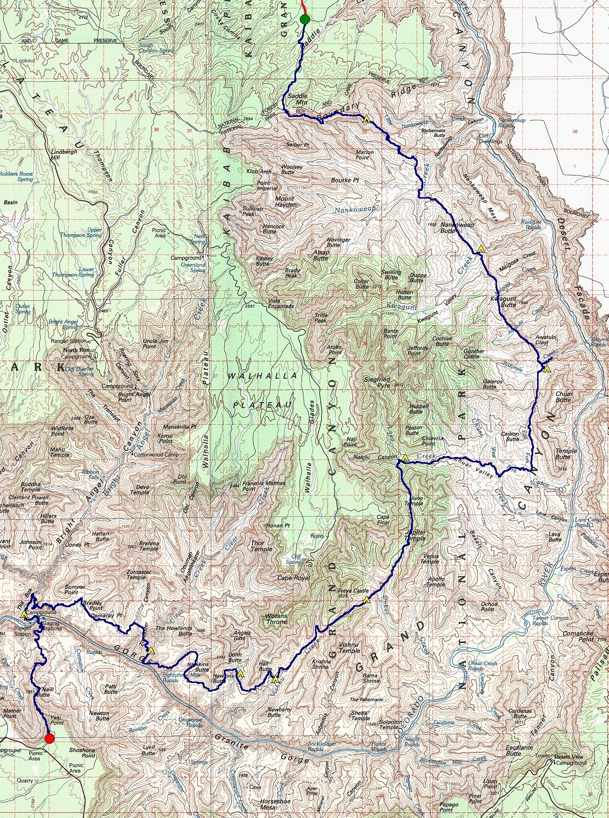
Trip Route Map
|
Day 1 : We met our shuttle driver at 7:30, and by 10 a.m. we were delivered to the Forest Service trailhead at the end of road 445 on the Marble Platform. At 10:10 we loaded up our packs and started up the Saddle Mountain trail. We got to the Park boundary about noon, and after just a few minutes headed down the Nankoweap Trail. There were snow flurries in the afternoon. After a 20-minute lunch we reached Marion Point about 2 p.m. We stopped for the night at 3:45 at the last flat Supai bench on the descent to Tilted Mesa and rigged our 15' x 20' tarp to cover all four of us.
Day 2 : I was awakened in the predawn dark by a face full of slush. A grommet in one corner of the tarp had pulled out under the weight of 2 inches of accumulated snow, dropping said snow on me. Some hurried repairs and sleep resumed. We lolled in bed in the early light, in deep denial about the weather, hoping the snow would stop. It did, and then started melting. By the time we left camp at 7:10 a.m., there was only ˝ inch on the ground and that disappeared once we dropped the first few hundred feet.
We dropped quickly down the Nankoweap Trail to below the Tapeats, then headed cross-country to Nankoweap Creek for a 9 a.m. breakfast. Now it was time to start our 2 days on the Butte Fault. Back on our feet, we were on top of the Nankoweap-Kwagunt saddle just east of Nankoweap Butte by 11:40 a.m. We had lunch on the way down to Kwagunt, and were camped by Kwagunt Creek by 1:20 p.m. Here we saw two dayhikers looping from Nankoweap to Kwagunt and back, the last people we would see for a week.
We had arranged with a river trip to have some supplies cached for us at the junction of Kwagunt Creek and the Butte Fault. Now it was too cold to enjoy the beer, but the canned fruit still tasted great. Our two non-drinkers had looked forward to sodas, but there was only one, and a pinhole leak had left it flat.
Day 3 : The weather seemed to be returning to Canyon normal, namely warm to hot, and we got a fairly early start at 6 a.m. Up and down, up and down, up and down. We zoomed over three saddles, each less gain than the last. We were on Kwagunt/malgosa at 7:30, Malgosa/Awatubi at 9:20, and Awatubi/60 Mile at 10:50. We ended up after lunch in 60 Mile canyon at 12:15. Time to hide in some great Redwall shade right at the junction of the two main forks of the canyon. An afternoon dayhike to look for the reputed climbing route through the Redwall showed only an enormous dropoff a short way downcanyon; no route there that we mere mortals could detect. In the evening we moved canyon Ľ mile up the southern fork of 60 Mile to find a place to camp that was out of the bed, as clouds were starting to reappear. An attempt to rig the tarp in advance of possible night rains only led to a sleep-disturbing flapping all night. No rain fell.
Day 4 : The clouds continued to slowly thicken. We started walking at 6 a.m., and were on the 60 Mile/Carbon saddle by 7:15 and down to the forks of Carbon Creek by 8:45 a.m. Now we finally left the Butte Fault and headed cross-country for Lava Creek, hitting it exactly at the spring shown on the 7.5' topo at 3400'. It was only 9:40, but there was another cache to recover. This one had 3 pounds of gorp in it besides the "standard" beer, Dr. Pepper and canned fruit. We set to gorging ourselves in order to reduce the load to be carried. Two hours later we started upstream.
We reached the source spring for Lava Creek at 4400' by 2:30, just downstream of the Natchi Canyon junction. Another 200 yards upstream was the large Tapeats overhang which has sheltered an Anasazi ruin for at least 900 years. Tonight it sheltered us as well, as serious rain began while we were collecting water from the spring, and continued off and on for hours.
Day 5 : Time for the Vishnu Fault! We climbed through the Tapeats directly across from our previous nights camp, after a 6:30 a.m. departure, then contoured into the bed of the southwest arm of Lava Creek. We saw a potential Redwall route on the wall to our right, but stayed in the bed until the final cliff at the top of the Redwall. We got there at 9 a.m. Scouting revealed three apparent choices: scramble up 20' to the left of the main bed, then contour on the cliff back into the bed, climb directly up the falls in the main bed, or climb a short route on the face to our right, starting at the top of a 50' high talus pile. The traverse looked tenuous, the bed looked too steep, and we went for the face.
The climb turned out to be harder than it looked, requiring almost all of our 80' rope and 3 protection placements. Once the rope was in place, the remaining three of us climbed with our packs on, and then our best climber went back down and climbed up with his pack. In an hour and a quarter we were all up, and proceeding through the remaining bit of Supai to the Lava/Unkar saddle. Lunch on the saddle, and then down towards Unkar and its dubious water supply.
We needn't have worried. The Unkar descent was easy, and there was pothole water in the top of the Tapeats from the previous day's rain. We played lizard there from 12:50-2:10 p.m. in the early afternoon sun, happy that we wouldn't have to dayhike down Unkar to look for water. It was still cool enough that some of us preferred sun to shade. Then we put our packs back on, descended around the Tapeats falls, and walked back up to look at the Tapeats falls from the bottom. Finally we continued down to the main Unkar drainage. We went straight on across following the Vishnu Fault trace, and started up the canyon heading for Vishnu. Camp was once again under a Tapeats overhang, this time a north-facing overhang with no ruins. We camped about 4 p.m.
Day 6 : Another day in the Redwall. We started up about 6:30, and had no problems in the Redwall. A steep section in the bed at the top was climbed by all with packs on, after an initial pack-free scout. We reached the Unkar/Vishnu saddle and its incredible views of the South Rim and Krishna Shrine about 9 a.m., and settled in for a lengthy rest. After fully absorbing the views, it was time to descend the fault ravine on the Vishnu side. We could see from the top that the way was steep but doable for a long way down. Below that we knew there was a ravine that had stopped George Steck, though not his brother Alan. We had talked to George beforehand and been assured that we would have no problem finding the exit ledge. How could that be? A ledge in the Redwall? But sure enough, there it was, a most improbably large ledge leading off to the right at the bottom of the Redwall. It didn't seem to be the Muav rim (itself an improbable concept), but rather the top of the bottom 50' band of Redwall cliff.
We followed the exit ledge for a long way around the corner to a steep talus slope, and descended by a variety of paths in order to avoid kicking rocks on each other. Lunch was under a large tree in the bed of Vishnu. Then it was on down to camp under yet another beautiful overhang, this time in the quartzite narrows of Vishnu at about elevation 3800'.
Day 7 : The group splits up. One of our group was suffering from iritis, a painful inflammation of the iris of the eye. His medication, usually effective, didn't seem to be working and he was worried he would run out completely. So he decided he would hike out early on what would have been a rest day. Another of us went with him, while a 3rd accompanied the two departers part of the way. The three left camp at 5:10, following the Tonto, and rounded Hall Butte by 6:20 a.m., still in the morning shade. There the dayhiker left an 8 quart water cache for the next day and continued on with the other two. They crossed the drainage between Hall and Hawkins by the route described in Steck's Loop Hikes II, using a rope to haul one pack on the ascent just above a patch of Hakatai. At 8:10, nearing the southern tip of Hawkins Butte, the dayhiker turned back and the other two continued on along the Tonto towards Clear Creek.
As it turned out, the two who left early failed to find the correct chute down through the Tapeats below the Howlands/Angels Gate saddle and continued on the Tonto below Angel's Gate until they found pothole water in a ravine. They camped for the night there, and then retraced their steps the next morning to find the correct descent ravine, reaching the foot of the Clear Creek Trail at 9 a.m. of Day 8. At that point our iritis sufferer took off on his own for Bright Angel Creek, where the rangers put him up overnight and saw him safely out the next day. His partner stayed at Clear Creek.
Meanwhile, the other two of us were reunited at Vishnu Creek by 11 a.m., and spent the heat of the day snoozing in camp at Vishnu Creek, and then lounging near and in the pools in the ravine which comes from north of Hall Butte and enters Vishnu Creek at about 3800'. We left that ravine just after 4 p.m. when the heat of the day had abated somewhat, hiked the Tonto to the tip of Hall Point, and picked up our water cache at 5:20 p.m. Then we descended into the drainage between Hall and Hawkins and camped about 6 p.m.
Day 8 : While one of our now-divided group was hiking out the Clear Creek trail and the other was reading Lord Jim at the foot of the Clear Creek Trail, the remaining two of us persevered with the original plan, packing to the mouth of Clear Creek. We left camp at 5:15 a.m., and by 8 a.m. were at the top of the route into 83 Mile Canyon described in Steck's Loop Hikes II. Sure enough, there was a large slumped block of Tapeats reaching to within 20' of the Tapeats rim. Sure enough, there were the three separate ducks left by George Steck in 1980. But the 20' looked like an irreversible free rappel, and there was no sign we could find of Gary Ladd's later rope-free route down. Plus, descending the slump itself looked somewhere between very difficult and impossible. We gave up, and headed north on the Tonto towards the head of 83 Mile canyon.
An hour later we were at the ridge running east from Dunn Butte, still south of the main bed of 83 Mile canyon. A 15-minute scout had revealed a feasible Tapeats break, and down we went. The route went down a steep but secure crack in the Tapeats, which we both negotiated with packs and without rope. Then it was an easy walk down 83 Mile to rejoin the Steck route to the moth of Clear Creek. We left 83 Mile at 9:30 about 150 paces below its confluence with the arm coming from Hawkins Butte (the "Steck Arm" that we would have been in if we could have followed George's route). We could have gone another 100 yards to the next ravine and gotten out there also. We climbed up the slaty schist to the base of the Tapeats, then contoured extremely slowly along through very loose schist until we could look down into the descent ravine which reaches the River just upstream of Clear Creek. Only 1000' vertical feet to the River, and not much more horizontally.
It was a relief to go down steep but fairly solid mixed grass and rock into the bed of the descent ravine. In the ravine itself, the descent was steep but fun, and the first two bypasses (first right, then left) were easily spotted. Then we came to a final bypass, only about 250' above the River, where the schist just looked too steep and loose to be passable. Out came the rope again. One of us downclimbed the schist with an upper belay, then we lowered the packs over the cliff. Then the second climber came down, and we were off again. 5 minutes later we were at the River, just as a private raft party pulled in for lunch. They were the first people other than our own group that we had seen for a week.
It was 12:15 p.m. when we reached the River. The beach had no shade, and we headed over to Clear Creek after lunch to hide from the sun there. We came back many hours later, packed up, and hid some more. Just at 6 p.m. the sun finally set on our beach, and we put on our packs once more and walked over to Clear Creek, and up the creek 1/2 mile to just above the "Sideways Waterfall". There a wide spot allowed us to camp slightly above flashflood range, and at the base of the morning's ascent. It was 6:40 p.m. We had dinner and went to bed.
Day 9 : Trail at last!
We awoke before light, and started walking at 5 a.m. with first light. We did not want to be climbing in the schist in the heat of the day! The scramble up to the Clear Creek/Zoroaster ridge went perfectly, if strenuously, and we reached the easy walking of the saddle by 6. We strolled up to the base of the Tapeats just ahead of the sun, and contoured in shadow along the Tapeats base until we were just above the bed of Zoroaster Creek. A quick 50' downclimb in the red granodiorite put us in the bed of Zoroaster before 7 a.m. We walked down to see the phenomenal sculptured rock where Zoroaster Creek pours off into the schist, then shouldered our packs once more and headed up the west slope of Zoroaster to cross the Clear Creek Trail. We hit the trail at 7:15 a.m., due east of the tip of Demaray Point, a few minutes after the sun hit us. I opened a beer and prepared to walk the trail while sipping. "Drinking and driving, eh?" said my partner. After the cross-country ups and downs of the previous week, the Clear Creek Trail was a level highway. An hour later we caught sight of our missing partner who had spent the previous night at the end of the Clear Creek Trail. He too had left camp at 5 a.m., but with more miles to cover was only a few minutes ahead of us.
The three of us walked on together to Phantom Ranch, arriving about 10 a.m. We met a ranger just as we entered the Ranch, and learned that our iritis-suffering partner had successfully left that morning. A quick phone call to the South Rim and we had his plane reservation changed for him before he even got out of the Canyon. The rest of us spent the day lazing at Phantom Ranch before ambling down to the campground in the afternoon.
Day 10 : Up at 4:30, breakfast at Phantom Ranch at 5, on the trail at 5:15, Yaki Pt. Trailhead at 9 a.m., Las Vegas airport by noon. When it ends, it ends fast. We had a great, safe, scenic trip. A million thanks to George Steck, without whose writing and encouragement we would neither have tried the route nor succeeded in hiking it.
|
|
|---|
|
|---|