Rim to Rim to Rim and Phantom Creek
April 17 - 25, 1998
Jerry Forester, John Leonard and Norm Kern
Rim to Rim to Rim and Phantom Creek
Plans :
This trip fulfilled three basic goals. Norm "collects" bridges, so
he wanted to cross both bridges in the Grand Canyon. John had always
wanted to do a Rim to Rim so why not a Rim to Rim to Rim? Jerry never
likes to be around too many people so we had to plan to minimize the
contact even though we were in the corridor. Spending 6 days on the north
side of the river before the North Rim opened allowed us to meet this
objective and the Phantom Creek side trip really provided solitude.
Getting to the Canyon
The flight was uneventful and included breakfast.
We bought gas at a camping store in Phoenix and water and oranges at a
Safeway in Flagstaff. We bought Subway sandwiches at a gas station and ate
them outside (sitting on rocks; like we needed an extra meal on the rocks).
As is our custom we reached the rim just as the sun set. We ate dinner at
the Bright Angel Lodge dining room. We slept better than we have on other
trips but had to endure the motor home generator for a while and then a car
alarm at Mather Campground (reservations required).
Down to the Bottom
We did not awake until 6 o'clock (9 by Michigan time).
It was COLD. Norm was happy he had gloves and all were happy to have
stocking caps. We wore all the shirts and jackets we had with us. We
fired up the stove for coffee and oatmeal to be sure it worked, then
stopped by the Yavapi Cafeteria for more coffee. We went to Mather Point
to drink it and look over the S. Kaibab trail. We could see the trail
clearly on and beyond Cedar Ridge, but we could not identify for sure how
the trail got down to Cedar Ridge. Did it stay high or not? We could see
up the North Kaibab trail and had a good view of Utah Flats.
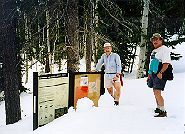
When we arrived at the trail head we learned that we would not be allowed
to park; in fact we weren't even supposed to drive up there. We quickly
dropped Jerry and the packs off and went to find a parking place. A kind
shuttle bus driver suggested a picnic ground nearby or the scenic overlooks
nearby. The picnic lot was full and the scenic overlook lots looked too
vulnerable so we went back to (yes, you guessed it) Yavapi Lodge to park.
The shuttle bus picked us up and we were on the trail by 9:45. We did not
hustle, as we were happy to be bringing up the rear to avoid a few more
people. We have no history of catching up with people so it was a pretty
safe approach. It was still brisk in the shade and there was ice on the
puddles. The trail is wide and well prepared (for the mules). There seem
to be some special cairns for (or by) the mules. They are green and
aromatic.
Our first OOPE (out of pack experience) was at the rest rooms on Cedar
Ridge. This was quite short as there were about 100 people and 2 dozen
mules. We stopped for a longer stop in the shade below O'Neil Butte. By
the time we got to the Redwall descent, we were in the full sun and the
next shade was the solar outhouse on the Tonto platform. John and Norm
were not excited about the ambience but were happy to have the shade. As
we ate lunch we were visited by our first ever backcountry ranger. It was
Todd Van Something, who was also the Cottonwood ranger. He checked our
permit and assured us we would see him again. (On six other backpacking
trips we had never had a ranger check our permit.) We saw some raggedy
looking squirrels. They need
to polish their begging technique if they were going to get fat and bushy
like the Bright Angel Squirrels.
The trail is only on the Tonto for about 50 yards and then descends into
the Tapeats. As it crossed the Tonto trail we were happy we were going
down and not "across" on the Tonto trail like the group we saw. We were
surprised to meet people who were coming up as we descended this lower part
of the trail so late in the day. We expected this section would have been
clear of people coming up by 9 or 10.
We crossed the black bridge at 3:30. 5 hours and 45 minutes to descend the
6 miles. Norm's toes were feeling pretty jammed into his boots. After
dinner John and Norm crossed the Silver Bridge. Jerry was not interested
in walking on this bridge since you can see through the grating all the way
down to the river. This completed Norm's goal of crossing the suspension
bridges at the bottom of the Grand Canyon. While we were near the river we
saw a Big Horned Sheep above the River Trail on the South side of the
river. We slept under the stars but it was cold enough that Norm was
literally shivering, and had to mummify himself.
Up to Cottonwood
Jerry awoke feeling poorly so he went back to sleep.
John and Norm walked to the ranger station to get trip tips on the Phantom
Creek route. The original plan was to wade up Phantom then to go over Utah
Flats. They learned that Phantom creek required wading in waist to chest
deep water to cross the pools. Harvey and George hadn't mentioned exactly
that. We started to consider the Tonto route down from Cottonwood. The
ranger advised that going up Phantom creek wasn't much fun even at low
water, but in the spring it would be a real drag. Jerry eventually awoke
and felt a little better but still couldn't keep much food down. By about
10:15 he felt well enough to leave for Cottonwood. We saw only one party
going up, and eventually saw 4 parties coming down from Ribbon Falls; a
total of about 22 people. The trail is quite gradual and is pretty smooth
and wide. The major excuse for having this piece of trail in such great
condition is that the water line is underneath it. We stopped four times
in the shade of the overhang or other rocks, had lunch. John commented
that Norm always seems to find a place to sit there is a back rest. We
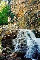
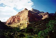
arrived at Ribbon Falls at about 3pm. We spent quite a bit of time at the
falls and took some pictures that turned out very well. It is a beautiful
spot. We climbed up behind the falls and watched the water hit the big
mound. We then arrived at Cottonwood Camp at about 5pm. Only two sites
were occupied. Ranger Todd recommended Site number 4, and he was right.
It was a little further from the other occupied sites, was the right size
for 2 small tents, had a nice view, and was far enough from the whine of
the water system that we could not hear it. Unfortunately even site
number 4 had the gnats. We slept in tents, because it was a little cooler
at the higher elevation.
On to the North Rim
We were on the trail by 7am without packs.
Cottonwood is not quite up to the Tonto level so we had about 4,000
vertical feet do climb and descend. We made good time and stopped less
frequently for shorter periods than we do with the packs. Roaring Springs
is spectacular. There are actually about 5 different springs gushing out
along the north wall of Roaring Springs Canyon. They all cascade down
hundreds of feet. This is where the water lines to both rims originate.
From Roaring Springs, North, the trail is used for mule trips but since we
were there before the North Rim opened, there were no mule cairns to avoid.
It seemed pretty wide to Norm but pretty narrow to Jerry. To control
erosion and run off, there are many diversion devices, of wood or stone.
The mules must be very sure footed to cross all these without stumbling.
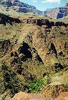
The most memorable stretch (for John and Norm) is in the Muav and Redwall.
It is a trail with hundreds of feet of wall on one side and hundreds of
feet of fall on the other. Jerry said he just watched the corner where the
wall met the trail and the feet in front of him. Norm and John greatly
enjoyed the view across Roaring Springs Canyon. Due to the snow melt above
there were about 6 little waterfalls which came down near or directly on
the trail. We got to see active waterfalls where the summer crowd would
just see rock. We could see them originate hundreds of feet up and cascade
down through several shelves and falls. In the morning we did not get too
wet even when the water fell right on the trail, but on the way down after
the sun had increased the melt rate, we got quite wet a couple of times.
We were happy it was warm. We wanted to rush through to keep from getting
drenched but we had to go slowly because the trail was right on the edge of
the abyss and the wet rock could have been slippery.
There are some landmarks on the map that kept us appraised of our position
and progress: the bridge, the tunnel. We stopped for a longer rest just
after the tunnel. We soon found our first snow on the trail. It was in
intermittent stretches of 10 to 100 yards but was at least 3 feet deep.
There were footprints of two other people who had packed a trail, so we did
not "Post Hole" too much. The snow was continuous through the Hermit
Shale, and was intermittent in the Coconino at the beginning. By the top
of the Coconino it was uninterrupted and stayed so all the way to the North
Rim. The ranger had said that he talked to only one person who had tried
for the North Rim this year and had been turned back by deep snow. We
thought perhaps we would be turned back too, or perhaps we would be the
first of the season to make it? We could make out tracks from two
different boot treads in the mud, and they both went in both directions.
The tracks in the mud and snow made it all the way to the rim and so we
followed them. There were two snowballs at the top, perhaps made by the
two hikers. It felt great to be the second party of the season to make the
rim, and to be on the North Rim all alone. We joked about a ranger asking
us where our car was parked and telling him it was parked on the South Rim.
The only ground not covered with three feet of snow was a single lane of
road. We sat in the road, ate lunch and napped with our heads on our
canteen pillows. We wore only shirts and shorts but were sweating even
though there was snow on the ground. After cooling down however, we
started to get uncomfortable when clouds covered the sun.
After lunch Jerry lead the way down. The snow was warmer, slipperier, and
we ended up doing some post holing. We all ran out of water so filtered
some just above the tunnel where we rested again. Norm used a zip lock bag
to catch the water and Jerry pumped. This water lasted us down to the
residence of the pumping station engineer. He has a sign inviting hikers
to get water and in the summer often has lemonade. He came out and talked
to us for about 15 minutes. He has been there since 1972, raised three
children there and can't image anywhere better to live. He said the park
runs a helicopter shuttle weekly to supply him and the campgrounds. That
station pumps only to the North rim, so he leaves in the winter and lives
near the south rim. The water is carried by gravity to Indian Gardens on
the South side where there is another pumping station for the South Rim.
The pumping station engineer was the only person we saw all day. We
arrived back at camp at 5:30 (14 Miles). As the sun was setting we watched
the parade of jets and vapor trails criss-crossing the canyon. John
guessed at their destinations. We talked about alternatives for our extra
layover day, and decided on visiting the Transept, which Harvey
recommended. It would require a crossing of Bright Angel Creek but we had
crossed creeks before.
Wall Creek
We walked up and down Bright Angle Creek to find a good
crossing point to get into the Transept. The flow was stronger than we
really wanted to cross so we decided to go down to Wall Creek and explore
there, since it was on our (the East) side of the Bright Angel Creek.
Walking up Wall creek was like walking up Shinimo in Merlin's Abyss (see
Circumnabulation of Powell Plateau). There was no trail and we crossed the
creek several times and walked through brush, bushes, branches, ankle
biters, and avoided cactus. We stopped for snacks in several pretty
places. Jerry left his T-shirt in the first one under some cottonwood
trees, since the day was warming up. We were sure to see it on the way
back, and we had to come back that way. We next found a beautiful 12 foot
waterfall, then a quartzite alcove half bowl, then some huge cottonwood
fallen trees which served as nice seats for serious lunch. Norm had smoked
trout that was heavenly after canned chicken. On the way down to the mouth
of Wall creek we walked back up a water shed up to a steep seep which was
shaded and cool. As usual it did not seem possible to find our exact route
again. Jerry lead and by hugging the north side of the water shed we made
great time and found ourselves back at the North Kiabab trail. But the new
efficient trail did not take us by Jerry's shirt so back up we went to find
it. Since we were not sight seeing, it did not take too long and we used
the north side route to finish up quickly. It was still a mile or more
back to camp and we were out of water since we had not brought the filter.
When we arrived back at Cottonwood camp we were plenty thirsty and tired.
Our site was not shaded so we flopped down in one of the group sites near
the water spicket. The shade was great and we were ready for a nap, but the
flies made it impossible. Norm went to sleep in his hot but fly free tent,
and then went down to cool off in the creek. John and Jerry joined him.
After dinner we studied the maps and talked quite a bit about the Phantom
Creek route, and although the enthusiasm was limited we decided to do it as
planned, that is go up Phantom Creek. None of us like long treks on the
Tonto and we preferred the notion of a loop rather than go up and back over
Utah Flats.
Phantom Creek? No, Utah Flats
We hit the trail about 7:15 which was
pretty early for us on this trip. We quickly noticed the difference of
being back in packs again. Being down four day's food didn't seem to make
much difference. Since we knew we would be near the creek, we did not even
have full loads of water. It could have been (and soon would be) worse.
When we got to Wall Creek we noticed the flow was much heavier than it had
been when we came up to Cottonwood. It was so strong that the carefully
selected and placed stepping stones were totally covered with water which
was so clouded with sediment that we could not find the stones. Norm just
waded across, and Jerry and John followed suit. We thought we would get
our feet wet down at Phantom anyway. It was about there that we started to
see how much higher Bright Angel Creek was, and how clouded it had become.
When we got to the Ribbon Falls bridge, Norm stopped to talk about the
plan. He suggested that we had some new valuable information: the warm
temperatures had just about doubled the flow rate in the creeks we had come
to know a little, and so the flow in Phantom Creek would probably be double
too. John quickly got consensus that we did not want to hike the stock
trail over the Tonto route to Phantom Creek, and so we decided to go down
to Bright Angel Camp, rest until near sunset and then climb up to Utah
Flats. We took a long break at the mouth of Phantom Creek but no one
seemed tempted to cross and hike up. The rangers had said that hiking up
was a drag in low water. This would be much worse. We arrived at Phantom
Ranch at about 11:30. Norm bought Iced Teas and we browsed through old
Grand Canyon books from their reading collection. We then walked down to
see ranger Shore. He gave us some advice about getting up to Utah flats
and down to Phantom Creek. He said "You will wonder why you are staying
high so long when you can see Phantom Creek for so long." We found shady
spots and enjoyed napping or soaking our feet in the creek. By about 3:30
it was getting shady on the hillside even though it was 100 degrees in the
sun. We started up, with full loads of water. The trail starts at
campsite number one, the northern most site. The trail was steep but
loose. We followed the trail up to the rounded rock Shore had pointed out.
We found the trail up to the cliff that most people climb and also found
the trail around to the right and up which Shore had told us about. Norm
was exhilarated by the climb and the route finding through Piano Alley.
There were hundreds of sandstone pianos to climb over, around, and through.
After about an hour and a half we were up in the opening to Utah Flats.
The Tapeats is smoothed into rounded but huge blobs that seem stacked up
like steps. They are so big and smooth that you can not climb up in most
places. As we kept going west we found a way up and onto a more soft and
level shaley spot where we set up camp. There was one rock for the stove
and about 25 feet away there were some rocks to sit on (the dining room).
Utah flats is about 1500 vertical feet above Bright Angel Campground. As
we were unpacking our stuff the sun was over a hill, so we were in shade
but the pinnacles to the east were afire with the sunset. Norm noted how
blessed we were to be in such a place at such a time. Someone broke out
more Pringles. There was no shelter there but there was also no wind and
it was perfectly clear. We slept under the stars and watched for
satellites and planes. There were many.
Phantom Creek
We got going at about 8; not too far to go, so no big
hurry. George Steck's book says he could not find a trail across the
flats, and neither could we. We had never seen such a dense patch of
cactus as on the plateau between the exposed Tapeats sections. If
yesterday was Piano alley, this was cactus alley. We stayed to the right
of the blister of sandstone on the slope and as we crested the slope we
could see trail below us and off to the left. It came out of the first
water shed we would have to contour into. Once we picked up the trail it
was pretty easy to follow, although there are precious few cairns. It
stayed at about the same level for quite a while. Ranger Shore said we
would wonder why we were staying high so long. We did. At about 9:30, on
the west side of the water shed, Jerry (as usual) found shade in the
desert, in a shale alcove. It was welcome. Almost immediately after the
alcove we found ourselves on a loose, steep descent to the creek.
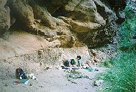
As soon as we got to the creek we got a bucket of water and set it aside to
settle. Norm was out of water and John and Jerry were low. Jerry found a
nice shaded spot under a rock overhang right next to the creek. We lounged
a little. We had read about the waterfall, and John had struggled to
figure out where it would be on the map, so we wanted to see it. We knew
from Ranger Shore it must be just down the creek from our position. We
made our way down stream but got cliffed out and had to cross and recross.
We found one of the sheltered camp spots on the north side of the creek.
The creek was running so high we could not get to the good vantage point to
see the falls from above so gave up and went back to the shady spot for
lunch. We filtered some water but Jerry had to clean the silt out of the
filter several times for just a canteen and a bottle. We hoped that above
the confluence of Phantom and Haunted, one of them would be cleaner and so
we headed upstream to find a campsite and cleaner water.
Soon we saw signs of the other party whose permit allowed them to be in the
Phantom Creek use area. There was one fellow at the campsite and he
directed us to some pools they had been using to filter water. They were
next to the creek but were seep pools and so were not as silty. We got all
the canteens and some bottles filled and then the creek level rose a few
inches and flooded the pools with silty water. Norm went up stream while
Jerry and John worked on the water. He found a nice sheltered campsite on
the South side of the creek and lead John and Jerry to it. We explored
little and relaxed for the rest of the afternoon. Jerry found a clear pool
next to the creek for filtering water. As we relaxed the rest of the other
party came by. They had been up to the source for Phantom Creek and told
us about a cairned trail up through the Redwall to Shiva Temple. They had
not taken it and seemed about as likely to as we would be (very unlikely).
Phantom Creek & Back up to Utah Flats
We had the morning to explore and
sight see. We headed up Phantom Creek. Haunted Creek comes in from the
North, and above the confluence Phantom was cleaner. Jerry and John bathed
and we all relaxed at a wide spot in the creek. When we got hungry for
lunch we headed back to camp, ate by the creek, took a nap, and filled up
all our canteens and bottles to prepare for the night's dry camp on the
Flats. We did not want to be up on the flats in the afternoon sun so we
timed our departure to get us up there about the time the sun went behind
the hills. Even though the packs had only 2 days food, they still felt
heavy with all the necessary water. It was gusty again but as we went
through the other party's campsite it was like a wind tunnel. They were in
a very narrow spot with rock walls on both sides, so it was probably worst
there. They said we would be blown off the Flats. The climb up to the
Tonto was not as bad as the descent. The footing is better going up than
coming down. You don't have gravity fighting you for control. Norm was
relieved when the steep climb was over. We were surprised at how short the
ascent seemed compared to our memory of the descent. It took us back to
the shale alcove and we took another break there. The rest was basically
contouring through the watersheds and it was basically up and down in small
increments. We lost the trail at about the same spot we had found it.
Jerry lead us back to the campsite and although we stayed a little higher,
it was about the same route we had taken the day before. John tried to
tell us about a ledge we had to descend but Jerry and Norm were sure there
was no such ledge. John said "OK, fine, see you in camp", and then Jerry
and Norm found the ledge. John always has the best trail memory. There is
little point in arguing with him. We arrived in camp at about 5, and made
good time with few stops. Tomorrow would be a tough day so we agreed that
anytime after 5am, whoever woke up first should wake the others. We slept
under the stars again, although it was more overcast.
Bright Angel Camp and Back to the South Rim
Jerry was first to wake and
got us up. We were walking across the Tapeats flats by 6. John's great
trail memory got us down to Piano Alley where we picked up the trail. It
was looser going down than it had been coming up so it took great care. We
arrived at Bright Angel Camp by 7:40. We dumped our stuff in a campsite
next to the wash room, changed into shorts, and used the facilities to
clean up. Before ascending the South Kaibab trail we stopped at Phantom
Ranch for a second cup of coffee. A little civilization is not all bad.
John let Ranger Shore know we were safe and sound and that neither Phantom
Creek party had gone up or down the creek. We started for the South Rim at
9, which made us about the last party to start up. The overcast from the
night before stuck around so it was cooler than it had been and the sun was
not as oppressive. There was even a breeze. We had planned our water to
have the canteens last to the Tonto plateau, the first bottle to the top of
the Redwall, and the last bottle to get us to the rim. On the Tonto, we
topped off our canteens and dumped out the remainder of the first bottle.
We met dozens of people coming down, few with full packs. The real
exceptions were three women older than we who had full packs and all three
had a ski pole in each hand. John and Norm had joked about the ski pole
hikers, but for these ladies we were all admiration! Several people asked
if we were coming all the way up from Bright Angel. A few times we tried
to explain that we started from Utah flats or at the Tonto elevation on the
North side. No one understood, so we gave up and just said yes. We did get
across to a few that we had been down for a week, not just overnight. A
few even understood we had been all the way to the North Rim.
We did not rush the pace and we all felt the exertion but we stopped
infrequently and for pretty short periods, so we made pretty good time. We
had lunch after climbing up the Muav and Redwall switchbacks, on the narrow
saddle that leads to the Supai. The overcast reduced the need for shade so
we just sat out next to the trail. All Jerry had left to eat was some
tuna. Norm had chicken but was so tired of it that he swapped with Jerry
for some beef jerky. We topped off the canteens again and dumped out more
of the excess. The next OOPE was at Cedar Ridge. Jerry had not liked
being there among all the people on the way down, but Norm refused to go
any further without a rest. At that time of day all the mules were gone
and the people were pretty dispersed. Norm got strained stares from a
young girl who was on a day hike with her family. He guessed 8 days below
the rim must make you look pretty interesting; 8 days of beard, little
washing, plenty of scrapes and scratches and clothes which have been soaked
through a couple of times. During the final climb through the Coconino a
couple observed our big packs and asked John if he would recommend it. They
chuckled when he said, Yes!
We rimmed out at 2:40 which meant we had climbed out in about the same time
it took us to descend. Not bad for 50 year old gents, especially
considering that we had to also do the miles down from Utah Flats. The
shuttle bus was idling so we hustled to get on. It was already full and we
had to stand WITH OUR PACKS ON. No one offered a seat. Another young
woman stared to ask Norm a question but when she got a good look, she
stopped short and said "Never Mind". Boy, how bad could he have looked?
He'd even changed his shirt by this time. An adult fellow did engage John
in a chat about our adventure.
We cleaned up at the Mather Campground Showers, ate dinner at the Sizzler
in Flagstaff, and arrived in Phoenix at about 9.
Lessons Learned
- The rangers know what's going on. Ask them for advice
about the routes and current conditions.
- Do enough research to know your options.
- Be flexible.
|
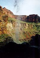
View from behind Ribbon Falls
|