GRAND CANYON TRIP REPORT
Who: Tim Ward and Kathy
Kerr, St. Paul, Minn.
When: March 23-28, 1998
Where: Grandview Point to the Bright Angel Trail via the Tonto.
Why: If you need to ask why you shouldn't be reading this :-]
We began the trip by flying into Phoenix, where Northworst Airlines lost
our hiking
sticks, along with a whole cartload full of golf clubs. Stood in line to make
arrangements to ship the hiking sticks to Flagstaff, with people grumbling
about missing
their tee times. We had a day to kill before entering the Canyon, so we
killed it on a
pleasant five-mile hike in Boynton Canyon, near Sedona, while being
appalled at the
Californication that has overtaken Sedona. I was asked, coming out, "Is
this the trail
to the vortex?" Argh. Damn New Agers. I wish they'd take their pyramids and
their
crystals elsewhere, as the town is terribly overbuilt.
DAY 1: Grandview Point to Horseshoe Mesa
Drove up from Williams, checked in at the Backcountry Reservations office
to get the
latest update on trail conditions and water availability, packed up at the
rim, and
headed down. After posing for our pre-trip photos, resplendent in our full
packs and
hiking sticks, Kathy was interviewed by a camcorder-toting Japanese tourist.
We shortly discovered that their advice to bring instep crampons for the
Grandview
should have been heeded. The top mile and a half were covered with a foot
of slushy snow
in spots. It made what would have been a challenging trail scary.
There was one really
bad spot where the trail hugged the side of a cliff, with a several hundred
foot drop
off the other side--tricky if the trail is covered in snow. At this point,
we slid our
packs in front of us and crawled around the corner. It took us nearly two
hours to
descend the first mile. After the trail dropped below the Kaibab and
Toroweap formations
(the top two rock layers in the Canyon), and entered the Coconino
Sandstone, it became a
bit more reasonable; still patchily snow-covered, but not as exposed. The
snow was with
us through the Coconino and Hermit Shale below it--anomalous in sunny, 65-degree
weather.
The trail moderated after dropping through the Hermit, and had a long, nearly
level traverse through the Supai Group, a reddish-purple formation of
alternating
sandstone cliffs and shale slopes. The trail in the Supai was occasionally
obscured by
rockslides, but was still always easy to follow. We were pretty tired from
the snowy
descent, though, so it took awhile. Finally the trail dropped down to
Horseshoe Mesa, a
flat, juniper-dotted plateau with a red butte rising out of the middle. On
the way down
to the mesa, we passed the entrance to Pete Berry's Last Chance mine
(mining copper,
closed around 1910) and hiked across the tailings pile. The hike was a
little over 3
miles, but it took us over four hours because of the snow at the top.
Crampons would
have helped. Watching the evening sunset light up the walls of the Canyon
was lovely.

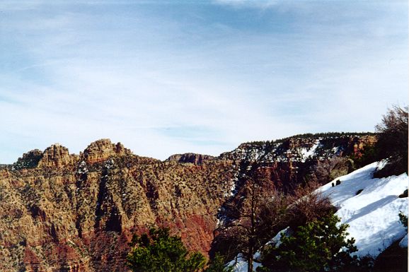
Sinking Ship from the Grandview Trail
DAY 2: Horseshoe to Cottonwood Creek (side trip to Page
Spring)
Awoke at 7 a.m., then headed on the side trail to Page Spring. Another
clear, warm day.
The side trail passes what looks like a winch, from the mine, then dives
off the mesa
through a steep break in the Redwall Limestone (the Redwall forms a sheer
cliff, and
thus any trail crossing it has to find a break in the cliff. The breaks are
nearly
always steep, so that descending the Redwall is one of the more challenging
parts of any
Canyon trip). There was an awkward scramble right at the top around a rock
jutting into
the trail, where a slip could very well send you sliding 100 feet down a
steep slope,
then over a cliff. After that, the trail switchbacks down a steep, rocky,
eroded trail.
Like climbing a staircase, with the steps all different sizes, and no
railing of course.
After this tricky descent, the trail passed another mine shaft with some
more mining
equipment, and descended a little more gently. I could see an opening in
the canyon wall
across from the mine entrance, right at the base of the Redwall. I hoped
that was the
spring, as it was getting hot and we were nearly out of water. Continued
downward; at a
signed junction the trail crosses the canyon and shortly arrives at the
spring, a
fern-covered grotto in the rock. Plenty of water here. We filled all our
water bottles,
then headed up the trail (not as hard as coming down). It was a little over
a half-mile
to Page Spring, but it sure felt like longer!
The trail to Cottonwood leaves at the ruins of the mess hall, near the mine
entrance (a
stone building about seven feet high, with a higher chimney still
remaining), and drops
steeply through the Redwall. The trail was rocky but not exposed. Still
tiring, though.
After about a mile and a half we crossed the dry streambed of Cottonwood, with a
wonderful view south towards the rim, where we could see snow at the top.
We had lunch
beneath a juniper (good campsite), and continued on the now-level trail,
crossing a
creek that drains into the main channel of Cottonwood, fed by some springs
a short ways
upstream. We continued to the junction of the Tonto trail, and a lovely
campsite framed
by two huge junipers. It was a fun scramble a short ways downstream into
the slickrock
of the Tapeats Sandstone. The stream spilled over a few falls, before we
came to a
20-foot one with a deep pool at the base. It looked like it might be possible to
scramble down it, but we didn't try. It was very windy that evening; felt
like our tent
was about to take flight.
This was our shortest day of hiking (maybe 2.5 miles with packs on) but the
side trail
to Page Springs made it a challenge.
DAY 3: Cottonwood Canyon to Grapevine Canyon.
Began on another clear, warm morning. Easy climb out of Cottonwood, and we
were onto the
Tonto Trail, the main cross-canyon trail. The hiking was fast and easy, as
we crossed
another side canyon with flowing water, as the main canyon was now hundreds
of feet
below us. We came out of the canyon and onto the rim of the Inner Gorge,
where we got
our first look at the Colorado 1200' below, running muddy red. Continued
past a small
side-canyon, and then reached the mouth of immense Grapevine Canyon, easily
the largest
of the side canyons we would cross on this trip. It was perhaps a
quarter-mile across
the canyon as the crow flies, but it's about six miles by trail. The views
here were
excellent, dominated by a huge butte called Wotan's Throne on the north
side of the
river. Wotan's Throne looks like a piece of the north rim separated from
the main rim by
a ridge, although on our map there appears to be no easy way up. It
dominated the views
for the next two days.
The trail swings to the south, and very shortly comes right up to the edge.
The rim of
the canyon is a sheer, ledgy cliff of brown Tapeats sandstone, five hundred
feet thick,
then the somber blackish-red Vishnu schist shot through with pink granite
below. The
trail was exposed, but level, and the footing was good. It's unsettling,
though, to be
walking along the trail and have your peripheral vision registering a huge
empty space
off to your right. The trail winds into numerous small side canyons
plunging over ledges
of the Tapeats into the main arm of Grapevine. About 2/3 of the way along,
we pass a
small seep with mesquite trees and some other leafy green shrublike trees I
don't know
the name of. After the seep is another exposed side canyon, and a scary
section as it
emerges from the side canyon on the side of a steep slope, and finally a
long traverse
high on the slope above the rim of the canyon, safe at last. In general,
though, this
side of Grapevine was easier than it would seem: numerous times we'd look
ahead and see
what looked like a terrifying stretch of trail--a few inches wide above a sheer
drop--but it was usually safer than it looked from a distance.
By the time we turned away from the rim, it was around noon, and very hot,
well over 80
degrees. The trail contoured along the slope for awhile, then dropped to
Grapevine
Creek, which was cool and clear, with numerous pools and small falls in the
sandstone; a
couple bathtub-sized pools made for a refreshing dip. There was a group of
seven hikers
from Utah, and we were later joined by two other groups. I think the BRO
may have
over-booked Grapevine tonight, as it was a little crowded, since there
aren't many good
sites. Either that, or one of the later groups was camping here without a
permit.
DAY 4: Grapevine Canyon to Boulder Canyon.
To our great surprise, although it was clear when we went to sleep, it
began to rain at
about 4:30 a.m. Quickly scurry out of the tent to put the rainfly on, and
manage to do
it without getting totally soaked. It continued to rain until about 7 a.m.
When we
awoke, it was cool and cloudy, and the clouds were below the rim. The trail
climbed up,
then back down into another arm of Grapevine, then up again, for the
traverse along the
west side of Grapevine. This was, mercifully, much easier than the east
side; it was
further away from the edge, and there weren't as many side canyons. Emerged
to see
Wotan's Throne in clouds, and turned to the west again. All along the Tonto
Trail we saw
tons of little purple wildflowers, blooming out of a low green plant that
was covering
the ground. There were also bright red flowers about 18" tall that looked
like Indian
paintbrush, but I didn't think Indian paintbrush bloomed in the spring. In
general, the
Canyon was much greener in March than I remember it being in summer.
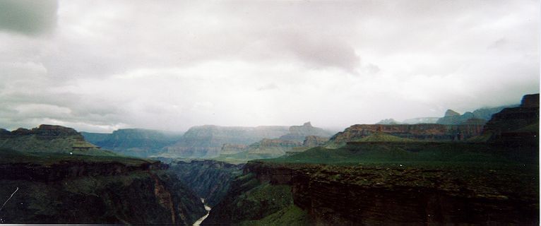
Colorado River and Inner Gorge, looking east from near
Grapevine Canyon
It was a short, easy hike to Boulder Canyon, with occasional drizzle, then
occasional
brief spells of sunlight. Boulder is not nearly as big as Grapevine, but
the streambed
is wider, and there are more campsites. There was no flowing water where
the trail
crossed the stream--the streambed was filled with sand and gravel, so the
water probably
was flowing underneath rather than at the surface--but a short hike
downstream found a
small trickle, and where the stream entered the Tapeats and flowed over
bedrock. We
filled our bottles at a small pothole about two feet deep, then continued
downstream to
see what we could find. A couple hundred yards further, we came to a
fifty-foot fall,
and could see a large pool and a bigger stream at the base, but no easy way
down. It
began to rain steadily around dinner-time, and rained off and on all night.
DAY 5: Boulder Canyon to West Arm of Cremation Canyon.
A light drizzle in the early morning kept us in our tent until about 7:30. Like
yesterday, it was a cloudy, cool day. The cloud deck was sitting right at
the rim, at
about 7000 feet. Occasionally it would clear up enough to show a patch of
blue and maybe
ten minutes of sunshine, then it would cloud over again, and rain for a few
minutes. We
had a little trouble finding the trail out of Boulder, but kept heading in
the same
general direction we were supposed to go, and we always found it again. The
cairns would
occasionally lead us astray. Shortly after leaving camp we passed two
hikers coming the
other way; their trail was about 20 yards to the left of the trail we were
on. This is
the first time that the Tonto's been as obscure as it was described. The
trail cuts
round the head of a small side-canyon, then swings back towards the lip of
the Inner
Gorge, before it turns again into Lonetree Canyon. The sky was fascinating
today; the
clouds would give us brief views of the top of Wotan's Throne, before
closing in again,
and there was sunlight breaking through the clouds east of us, beyond
Horseshoe Mesa.
About 30 minutes after that, we could see rain falling on Horseshoe Mesa,
while there
was blue sky above us.
The hiking was easy (except for the occasionally disappearing trail) into
Lonetree, the
smallest of the named side canyons we'd come into. The canyon was walled
off by sheer
Redwall cliffs on three sides, and there was a steady trickle of water
flowing. We
refilled our bottles and continued on towards Cremation, passing another
group of
hikers. Once again, they'd left their slowest hiker at the back, which
strikes me as a
Bad Idea. The straggler didn't seem bothered: he was an experienced Canyon
hiker who
with bad knees. He says he never filters or boils water he finds in the
Canyon, and the
only time he's gotten sick was from drinking out of the Colorado.
Unlike the other side canyons, where the trail swings around almost to the
canyon's
head, the trail here drops steeply into each arm of Cremation. We camped in
the third,
westernmost arm; the trail coming into the second arm was the steepest
(except, as we
would discover tomorrow, the trail climbing out of the western arm back
onto the Tonto).
No flowing water here, and not as many nice campsites as at Boulder. After
setting up
the tent, I followed the west arm downstream with no problems until it
joined the middle
arm. Here I turned around, but I couldn't see any drop-offs ahead, and I
was below the
Tapeats into the Vishnu Schist, which isn't as ledgy as the Tapeats. Maybe
it goes all
the way to the Colorado with no major obstructions, but I doubt it.
DAY 6: Cremation to South Rim via Bright Angel Trail
This was our longest day, about 10 miles total. In retrospect, it would not
have been
bad...if the weather had cooperated. We decided to go for the luxury of a
hot breakfast
with tea, coffee and the last of our oatmeal, and take the long way out,
getting water
at Indian Gardens or Pipe Spring, rather than go up the steep and
apparently very muddy
South Kaibab trail. I'd hiked down the South Kaibab in 1991, and I was in
no hurry to
hike up it. The climb out of Cremation Canyon was tough; steep and rocky.
At the top of
the climb we passed an ideal campsite; flat, with great views, and a huge,
house-sized
chunk of Tapeats leaning over at about a 45-degree angle making a nice dry
hangout. Had
we but known...
The trail continued level for awhile, then climbed steeply uphill again. We
could see
the South Kaibab as a slash in the side of O'Neill Butte; the trail
contoured away from
it, then back towards it. There is now a chemical toilet at the junction of
the Kaibab
and the Tonto that wasn't there in '91. It was a very welcome stop, as
there was a
little wooden balcony out in front of the toilets that made a good resting
place. A mule
train was going up the Kaibab as we passed. The Tonto continues straight
across the
Kaibab (it does not jog to the right, as the Trails Illustrated map
indicates), into a
small side canyon, then into Pipe Creek Canyon, which is huge. Coming
around into Pipe
Creek, we saw a clear patch of sky across the Inner Gorge, then a small
piece of a
rainbow at the base of one of the buttes on the north side. A lovely wisp of
iridescence, that faded away after about five minutes. This was the last hint of
sunshine we would see.
It was a long, but easy hike through Pipe Creek, which is beautiful, with
lots of
cottonwoods just beginning to leaf out. We passed two springs along the
way: Burro
Spring was muddy, spilling through cattails as the trail crossed it, and
Pipe Spring was
clearer. The west arm of Pipe Creek was dry, and it was a bit of a drag to
go through
it, since we'd already come about four miles and had a long ways yet to go.
We came around the bend, dropping down to the hiker's freeway--Bright Angel
Trail. It
was an easy walk to Indian Gardens, where we ate lunch at the foot of a
huge cottonwood,
and filled up our water bottles for the climb out. There was another couple
there, from
Tucson, who had hiked down to Phantom the day before. They reported it was
snowing on
the rim when they left. By the looks of the clouds, now hiding the rim
completely, it
looked as though it was still snowing. A passing ranger told us that a
blizzard was
heading our way, and would probably hit the rim in about 3 hours, with snow
as low as
Indian Gardens. This did not augur well for the hike out. We began hiking
steadily, in a
cold drizzle. The trail climbed gently for about 0.5 miles, then began to
switchback
through the Muav and the Redwall, climbing more steeply. The trail was
wide, well
maintained, but a bit muddy. As we climbed, it began to rain more steadily.
After a
seemingly endless series of switchbacks, we reached the 3-mile resthouse; the
thermometer there read 40 degrees. We could only see to the base of the
Coconino;
everything above was veiled in clouds. We stopped only for a little while,
as it was
cold and we weren't prepared for winter weather. The couple from Tucson
cought up with
us at the resthouse. Both Kathy and I were tired already, but there's no
point in
stopping.
I got into a slow, steady rhythm of taking two steps with each breath:
Ex...step...hale...step...In...hale...step, not noticing much but the back
of Kathy's
pack as we trudged up the trail. A long traverse across the ledgy Supai,
and another
series of switchbacks brought us to the toilets and the 1.5-mile resthouse.
Now it was
sleeting, and the wind was picking up. Another short stop, and again slowly
upwards.
Shortly after leaving the resthouse, snow began to mix with the rain, and
as we reached
the Coconino the clouds closed in, and the Canyon disappeared. We couldn't
see the rim,
we couldn't see Indian Gardens, only the trail, cliff, and the first few
hundred feet of
the dropoff a foot beyond the edge of the trail. Shortly after leaving the
resthouse we
crossed a recent rockfall; the trail had been cleared but it looks like the
rockfall
buried it completely when it came down. At this point the snow began for
real, and the
wind strengthened as we climbed. With a little less than a mile to go we
reached a short
tunnel, which didn't provide much protection. We caught up with some
dayhikers who had
turned around, and we headed up the rest of the way together, cold, wet,
and tired. The
trail was beginning to get slippery and icy. The rim didn't come into view
until we
reached another tunnel, and had to give way for a mule train. The mules
churned the
trail into mush, but their droppings improved the footing. At last, Kolb's
studio came
into view, we rounded the last switchback, and reached the rim in swirling
snow. We
stumbled a few hundred yards into the lobby of Bright Angel Lodge, standing
there
covered in snow, in a hypothermic daze, while hotel guests gawked. The mediocre,
overpriced meal in the restaurant was a godsend.
We barely made it back to our car, at Grandview Point, and I would like to
thank the
taxi driver from Fred Harvey who made a difficult 15-mile drive through
intensifying
wind and snow, and waited until we got our car safely out. I'd also like to
thank Daniel
at the Bright Angel lodge for spotting us $3 when we came up a couple bucks
short for
cab fare. It turns out that they got 15 inches of snow, and the roads
closed a couple
hours after we left. The drive back to Williams, a 55-mile trip, took
nearly three
hours, with blowing and drifting snow most of the way. After we left, I
noted that the
Grand Canyon had the nation's low temperature on Monday, with -4 degrees.
In general, we had a wonderful time, but the hiking was considerably harder
than we
expected (and we were both expecting it to be difficult). The descent on
the snowy
Grandview was easily the worst, and the last day was really too long,
particularly with
the snow at the end. The hike along the Tonto was beautiful, and except for
the east
side of Grapevine Canyon not at all difficult. We found flowing water in
all the side
canyons except for Cremation, and even there found a few pools. I would not
want to do
this hike in June, when the flowers would be gone, the water would be
nearly gone, and
it would be over 100 degrees every day.
|