|
Matt Averill's Grand Canyon Journal |
|---|
Grand Canyon Journal
by Matt Averill
Zionsville, IN
These photos were taken over New Year's break during a week-long backpacking trip through the eastern end of the Grand Canyon. I had planned the trip in August as a solo winter adventure through a remote portion of the canyon described by Colin Fletcher in "The Man Who Walked Through Time." I was interested in his description of the sheer cliff at Unkar Rapids and the beautiful beaches that lie farther to the east. I then pored over maps for weeks and carefully chose my route. I decided to spend 7 days in the canyon, starting on December 28 and climbing out on January 3. I would begin the hike on the Tanner Trail, hike down to the river in one day, spend the next day hiking up the Beamer Trail without a pack, and then spend three days hiking west on the primitive Escalante Route and eventually returning to the rim via the New Hance Trail. I filled out my backcountry permit application accordingly in late September and was ready to send it in when I received an email from a buddy who expressed interest in going. I cut open the envelope and changed the permit request for two people and sent it in. In November I received the permit and realized something was wrong. I should have planned for us to come up the Tanner and Grandview Trails instead of the New Hance Trail because winter conditions were notorious for making the New Hance unhikable toward the top. We would have to "guerilla" camp for a night on the way out.
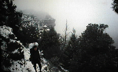
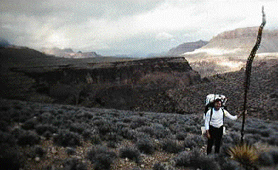
Day 1: We parked the van at the top of the Grandview Trail, caught a taxi, and began hiking down the Tanner Trail at about 10 a.m. A winter storm dumped about 3 inches of snow on the South Rim turning it into a winter landscape. The canyon was filled with clouds. Occasional breaks revealed a glimpse of the deep canyon walls below. The enormous void lay ahead of us down a slippery, steep, and snowy trail. Our packs were tremendously heavy with food, water, and supplies. We found that our hiking poles were a necessity!
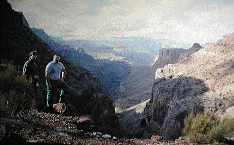
As we hiked out of Tanner Canyon and neared the top of the Redwall Limestone, the clouds began to break-up, revealing a tremendous view down the canyon of 75-mile creek. We would eventually reach the mouth of 75-mile creek several days later on the Escalante Route. We reached the bottom of the Canyon at evening and camped at Tanner Rapids, exhausted and sore.
Day 2: We rose early the next morning to a sunny blue-sky day. There were a couple of other campers in the area including two rangers. These would be the last people we meet for 4 days. We donned shorts, left the camp as-is and began hiking east along the Beamer Trail. The Beamer Trail alternates from hiking along beaches to hiking along sheer cliffs several hundred feet high above the river.
What a trip! My buddy Dave Stamper jumped in the river as the temperatures "soared" to nearly 70 degrees. We made it 6 miles to Lava Canyon Rapids before we had to turn back.
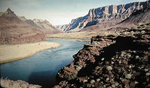
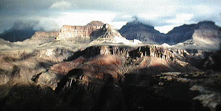
Day 3: We packed up and headed west along the Escalante Route enjoying another warm day. In the course of a couple of miles we reached Cardenas Creek. We took a dip in the river and cooked lunch. Dave took a nap and I explored the upper reaches of Cardenas Creek, a narrow slot-canyon at first, opening up later on. A very tranquil and beautiful canyon, indeed. We knew that we would have to hike to the top of Unkar Overlook that afternoon so we packed-up refreshed and began the haul up to the top. The cliff was not visible at first, but from the top of the trail we could see a side trail leading toward the edge. We reached the enormous cliff face and were stunned by the beauty of it all. We had to camp here! It was a straight 400-foot drop-off to the river below.
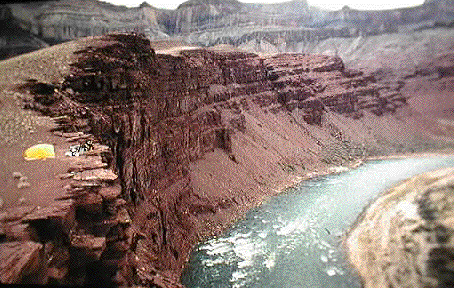
We set up the tent, enjoyed a coctail of Southern Comfort and lemonade, and cooked a tremendous dinner by the sunset on that incredible cliff. I slept outside staring up at the stars with my little radio, listening to tribal music playing on a local Native American Indian station.
Day 4: Leaving the cliff face we headed west toward one of the most challenging parts of the trail.....
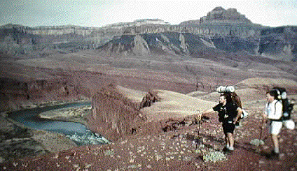
The route rose high and passed into and out-of a deep side-canyon offering wonderful views of Unkar Overlook and the canyon to the west. We were intimidated by what lay ahead, deeply incised slot canyons that we would have to navigate through or around.
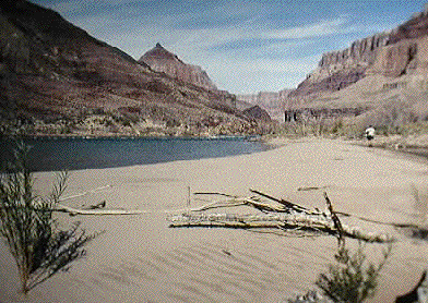
There were several false-trails and deep cliffs that we had to find ways around. Eventully we ended up at the river at the most gorgeous camping spot along the river yet. Steep canyon walls rose all around us, rapids roared, and a lovely sandy beach in a secluded cove all combined, along with a warm evening, a delicious dinner, and coctails to provide a fantastic New Year's evening. We slept outside beneath a clear starlit night.
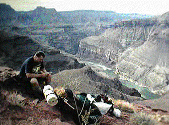
Day 5: The trail after this point didn't exist. There were cairns that pointed the way once and a while, but we had to find our own way through the slot canyons. Occasional dead-ends came in the form of 100-foot sheer drop-offs..
The trail rose up a very steep cliff and down an equally steep landslide to the willows that lined the river toward Hance Rapids. At Hance Rapids we ate a huge lunch and filled up on water. We hiked up the Tonto trail from there, leaving the water behind. We would have to carefully conserve water. The trail rose in and out of canyons to the Tonto platform which was suitable for camping. We camped on the Tonto among the tall and strange agaves.
Day 6: It was obvious we were in trouble. We approached the base of the Redwall Limestone and Horseshoe Mesa dangerously low on water. We decided to risk it and began the climb up the steep notch in the Redwall. We came to a sign that read "Page Spring." Nothing but dry land surrounded the area. Needless to say, we were dumbstruck. It was then that Dave noticed a green spot in the cliff a few hundred feet away. We followed a faint trail to it and heard trickling noises. Sure enough, a basin of clear, cold water lay within the rock, draped with ferns and mosses. We DRANK and climbed up the Redwall, past several abandoned mines, to the top of Horseshoe mesa.
It was here that we encountered some hikers trickling down from the rim. We kept going, wanting to reach the top by sunset. The trail was endless and we took frequent breaks. We reached the top at sunset. Better than thirty tourists were gaping out at the canyon as we dragged ourselves to the top. "I've been down there" I said to one of them, and walked away toward the van.
or check out his home page at
http://www.zionsville.net/hightech/team4/averill/mraverill.htm
|
|
|---|
|
|---|