|
Norm Kern's North Bass hike |
|---|
|
This trip was inspired by a brief reference in George Steck's Loop Hikes II to the possibility of going down The North Bass Trail and looping out through Merlin's Abyss. Even though George said he would never do this trip again because of the brush, we decided to try it. We all agreed afterwards, it was a great accomplishment, but the Merlin Abyss to the
Rim was not fun.
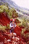
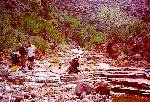
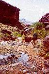
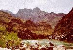
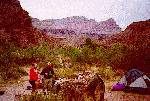
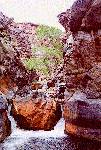
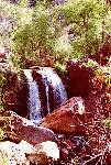
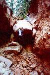
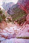
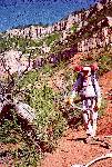
North Bass Trail Part 1 We arose, had breakfast and finished packing. John had left many decisions until that morning. Being on the rim about to put the pack on for 7 days helped him decide to leave much in the car. We were on the trail by 7:30. The trail reminded us of the Hermit and the New Hance Trails. Our internet information and George Steck's friend reported exposure in the Coconino. We found none. Perhaps you find it if you go over to the spring. We had no need since we had bought all the water we could carry, and had used almost none of it. We did find some brief exposure while crossing open slopes of Hermit Shale, were the "trail" was exactly one foot print wide. There was more brush here than we had experienced on any other trails. [We hadn't seen anything yet.] Norm enjoyed tracking progress by noting the progress through the rock formation. There was water in White Creek even above the Red Wall drop off. At the drop off we left the creek and followed the trail to the right, over three saddles just as the Sierra Club Trail Guide described. The redwall scree is very sharp, and so were the bushes on these saddles. [We hadn't seen anything yet.] After the second descent, we stopped for lunch. I think our legs told us it was time for a long break more than our stomachs told us it was time to eat. We all napped. We all tightened up during the longer rest, so the next climb which was immediate was even worse. John followed the trail along the base of a cliff and then down endless, loose, steep switch backs down to the valley floor, and to the Muav. John commented that he would ever have guessed the trail went across the bottom of the wall. Harvey Butchert calls that part of the trail "unlikely". Norm had provided John and Jerry with photocopies of pages from the Sierra Club Trail Guide, Loop Hikes II, Harvey Butchert's Grand Canyon Treks, some correspondence from the Internet, and correspondence directly from George Steck including photographs of the point where we should exit. On this first day we referenced the pages on the North Bass from the SC TG. John had been able to find 7.5 minute topo maps in Phoenix, even though the National Geological Survey Office is out of them. He used his copy hundreds of times to make sure we were where we wanted to be. In the valley floor we met a lone hiker, who turned out to be out in front of the other four in his group. We met two of them near and two of them at the Muav pools. There were several, of all sizes and shapes. Some just about bath tub size. Jerry said he was looking for the hot bathes. The other guys laughed. It was only about 3PM but we were about half way to Bass's camp which was our destination for tomorrow, so we stopped for the day. We waded and washed, and made coffee, and lounged, and took our boots off, and made supper (mashed potatoes and beef gravy) filtered a couple gallons of water with John's new filter, and generally enjoyed the beautiful spot. Life was good. Norm wasn't anxious to sleep on the ledges thinking about what it would be like if there were a flash flood. We moved up to a small sandy spot just big enough for the two tents right next to each other. Jerry slept under the stars (clouds actually). He and Norm slept fitfully. It sprinkled a little and the wind was up and down. They both woke early and went for walks until John awoke. Kolb picture spot, wading, and Bass's camp. We were on the trail again at 7:30. Jerry wasn't feeling too well but didn't complain. We started out going away from the creek to get around water falls in the Muav. There was a little exposure to get Jerry's juices flowing. Our thighs were plenty sore from the first day, and we were doing a little of the 'old man shuffle'. Eventually we rejoined the creek but there was no water. That made for easy walking. We rested where the creek bed descended into a deep chasm in the Tapeats. The trail lead to where the chasm opened up below. We dropped the packs and spent about 30 minutes enjoying the beauty, and the coolness of the spot. We took the same picture the Kolb's had taken 80 years before with the bolder stuck in the top of the chasm. It took us two frames to get our picture. Strangely the water seemed to now go around the chasm. It was almost entirely dry but below that spot the creek had plenty of water in it. At some point we missed the fork in the trail. The other route leaves the creek bed. We were happy that we had stayed in the creek bed to reach this spot. From the Tapeats we descended down into the Schist. By early afternoon we reached the Shinumo creek confluence. The joint flow made it much harder to stay dry when crossing, and just as last year we finally gave up and just waded. We were so close to our destination, it would have been nice to make it with dry feet. We expected to reach Bass's camp just after the confluence, but we had to cross the creek 4 or 5 times and we stopped for one more long break. By studying the maps and book pages we understood that we had not missed it but were not there yet. We crossed once more went about 100 yards on nice ledges and entered Bass's camp. People had gathered lots of tools, cook ware, nails, etc and placed them on a few boards for viewing. It was sort of a crude museum. We waded and washed a little in the creek. About a dozen river runners came up to see Bass's camp. They only stayed about 15 minutes. We had MRE's again and coffee. At Bass's camp and on at least two boulders we saw the following carved. WL Vaughn, Connor Texas, 5-17-1912. We don't know who WL Vaughn was, but 1912 is about when Bass sold out to the railroad and left the Grand Canyon. It was quite overcast again so we put up the tents. We slept right around Bass's camp. A Day at the Beach We awoke to find several nibbles at the packs. Jerry had a new hole in his pack. Norm had nibbles in a couple of zip lock bags. As planned, we found a place to hide our packs and just carried snacks and water and a few other necessities down to the beach Actually it was up and down to the beach. The trail climbs about 600 feet before it descends to the river. This is required. According to the Steck Book, following the creek leads to a water fall with a very challenging climb. Without the packs the climb and descent weren't too bad. The footing in the quartzite was fine, but the trail was almost indistinguishable since the quartzite doesn't wear down. It was overcast and only occasionally sunny and warm. It rained for a few minutes 3 or 4 times, once for about 10 minutes. A boat pulled in to the beach. We were fearful that we would have to share the beach with a boat party. The oarsman, asked if there was a waterfall near by. We waved him on down river. He left with few words and no smile. Jerry had brought sausage, crackers, and cheese dip to share. It hit the spot. Norm crawled around on the Schist for fun. John bathed quickly as one must in the frigid Colorado river. We shared the beach with the finches and squirrels. Norm laid down a cracker crumb trail to bring the boldest one quite close. We saw one other boat party; commercial but not Can-Ex. Norm and John played trivia which put Jerry to sleep. We could see where the 'flood' had left more silt on the beach. The tamarisk at the waters edge were clearly covered about a foot deep, and the water marks were well up the beach on others. We could see silt trapped in the schist several feet above the current water level. About 2 PM Jerry got so bored that he talked Norm and John into returning to camp. After having a cup of coffee at our new camp just below the pack hiding place, we ended up just lounging around. Jerry went off to clean up again but found there was no good way to get down to the creek from this camp. We were about 40 vertical feet above it. Norm updated the journal. Norm and John made a Lemon pie with graham cracker crust. We could see the weather coming across the Canyon, and so we had everything covered and the tarps ready to cover us. It rained for only about 10 minutes. We had Lasagna for dinner. This site was away from the Bass artifacts and seemed more private. Due to the rain we put up the tents one more time. Up Shinumo Creek (Leaving the marked trails) We had more nibbles on our packs and bags. Norm had tied most of his food up in a tree but something had knocked the bag down and gotten into it a little. John sacrificed a package of crackers which were pretty well beaten up into crumbs anyway. Through some unexplained accident we were on the trail by 6:45. John picked up some cactus needles as we passed through Bass's camp. They were not the last we would pick up. We reached the Shinumo/White confluence in good time without a crossing. By this point the trail was bushy, brushy, and bothersome;lots of bushes, bayonet plants, cactus, trees, dead limbs. We battled the brush and crossed back and forth. Occasionally we'd find a trail to go over a rock outcropping. Once we were off on such a trail on the right side, and it kept getting more and more difficult to follow. We'd follow it then lose it and then see another cairn and follow it and lose it again. It was steep and loose, and we finally go so high it didn't look like it was really going anywhere we wanted to go. We took a picture of King Arthur's castle from a point few people have probably reached. We wondered if the cairns were laid down as someone got lost and then used to get back down? At the creek we crossed and the going was fine, but brushy. [We still hadn't seen anything yet.] We crossed many times getting wet up to our knees. George Steck's friend said they switched to Teva's but we wanted to keep the protection for our feet. Everyone's boots held up just fine, even though they were soaked 4 different days. It was pleasant to be near the water, in the shade of the cottonwood trees. We all found our way into cactus at one point or another. Norm had to take his pants off to get some out from inside. Jerry got a needle in his tongue by biting needles out of his hand. We took a long rest on some Schist ledges where there were some gentle water falls and pools. John used one to soak his cactus filled arm. By lunch time we had reached the confluence of the Flint and the Shinumo creeks. George Steck suggested the log on the rope trick to get by the chockstone. On this day the flow was very very heavy and the log would have floated over the falls rather than catching. The pool below the chock stone was probably chest deep, but we didn't try it. We lunched and napped in the shade next to the falls and the pool. After lunch we set out to climb the 'nose' between the two creeks. We did not spend much time looking for a route. We started up a route on the south side of the nose. After doing it Norm was not so sure it was THE route. He said the climb 'pegged his adventure meter'. Some serious fingers and toes were required, and it was belly to the wall. John came back down without his pack to talk Norm up the last few yards. It helped. At the top of the nose we found the route back down to the creek easily. The rest of the day was brushy, bushy, and bothersome. As we hugged a Tapeats cliff on the left we found an indian ruin. It was a semicircular structure build right onto the cliff face. What was left was about waist high. We were striving to reach the Tapeats ledges which George Steck had recommended. We were expecting something like Deer Creek. By 6PM we were not there and we were beat and we found the only sort of flat, sort of clear spot we had seen for hours so we stopped. There was definitely no room for a tent, so we each found our own flat spot. Our pants, socks, and boots were all soaked so we all erected make shift clothes lines from plants, sticks or John's was a proper one made of line. Jerry cooked stroganoff which tasted great. No one was interested in Blue Berry Cobbler. Too bad; it's heavy. John did not have a sleeping bag. He had expected our normal hot nights and had a poncho liner. It was cooler than expected but he wrapped up in part of his tent to break the breeze. Jerry and Norm were under a sizeable Tapeats overhang. We never did see any Tapeats ledges worth mentioning. Merlin's Abyss, and on around the elbow. We were on the trail by 7:00. All slept just fine, but Norm had a dream about being responsible for some project in New York city politics. Probably a result of too much trivia before bed. About mid morning we found a beautiful 10 foot water fall. Jerry shared an orange. Fruit is a treasure in the canyon. When we passed the Morded Abyss junction we saw a flow of water, but it didn't seem to make much difference in Shinumo. It was still knee deep. Almost the whole day was again brushy, bushy and bothersome. We began knocking down dead sticks with our walking sticks. It made the walking a bit easier and let us get rid of some aggression on the brush. Norm leaned onto a bayonet plant which really drew blood. His pants were wet so the blood flow really looked bad. A few seconds of direct pressure fixed everything. We tried leaving the creek and going up into the dessert to avoid the brush, but the brush extended well up the sides of the Abyss and the footing was too steep to be enjoyable. Besides it was hot out in the sun. Back to the creek. This mirrored George Steck's experience. We tried hugging the cliff which had worked yesterday but we ended up going up higher than we needed and then getting pinched out anyway. The best option turned out to be hugging the creek edge, and just wading when it became difficult. About mid afternoon we had reached the Muav and rested on some nice level Muav ledges. We filtered some water because we were running low in our canteens. Jerry only filled Mr. Bucket up half way because he didn't want to carry any more water than we had too. Soon after that we were challenged by a series of huge chockstones. We found ways over and around them, but above them there was no water in the creek. This was a surprise based on what we had read. Without water in the creek we made excellent time. We might have stopped along there somewhere if we had water enough for supper, but... Eventually just about at the junction with the Northwest trending fault we found a trickle of water again. Soon after that while scrambling up a slope of rocks we climbed up into the perfect camping spot under a huge redwall overhang. Again we were soaked so we found places to hang our clothes and dry our boots. We knew water would be more scarce ahead so we all cleaned up to one degree or another. We had Turkey Supreme. Played Trivia by flash light. Redwall Chockstone, Tapeats Cliffs On this day we studied George Steck's notes and those of his friend. We hoped to get all the way up the NW trending fault and to the spring in the Ponderosas by evening. Norm said he hoped there were some markings on this part of the route. He was to be disappointed. The first part was wonderful. No water in the bed. Just routine bolder hopping. Eventually we reached the redwall chockstone described by George Steck. We quickly found the hole between the rocks we had to 'chimney' through. The hole was about 8 feet from the ground with poor holds on the wall. Jerry bent over and Norm stepped on his back, twisting his heavily cleated boots into Jerry's flesh. Norm found his way up quickly and easily with Jerry's help. John climbed it without assistance, with Jerry only spotting. Jerry tied on the packs and John and Norm pulled them up. John and Norm then put a loop in the rope and lowered it through the hole to Jerry. He used the rope to get to the Chimney move and came on through. Above the chockstone we found the little water fall George Steck had mentioned. It was flowing pretty well, and we filtered water to top off our bottles. We rested there for a while. The remainder of the redwall was uneventful bolder hopping because it was quite a gradual incline. The Supai was quite a different story. We couldn't tell from George Steck's narrative or map exactly where we were supposed to leave the water shed. When we saw a few possible exit routes staying in the water shed always seemed better, so we staying in all the way up to the beginning of the Hermit Shale. George had described 10 foot cliffs which were hard. We were finding cliffs which were hard, but they were much more than 10 feet. At the first one, there was no route on the right, but with a boost it looked like a route on the left. We found a dead log, and propped it up on the left. Norm went up first and kept going to make sure we could get over the other obstacles above. He was gone a long long time. He had climbed up to the next huge obstacle. He worked his way to the right looking for a route out of the water shed. When that option pinched out, he worked his way back to the left, and found himself above the huge obstacle. To see that this would not be the end of the line he went even higher. It looked like the Promised Land with a clear route to the top of the Supai. He went back down to tell John and Jerry. He kept getting cliffed out. He couldn't figure out how he had gotten up. John and Jerry got the packs up without Norm. They were waiting at the bottom of the huge obstacle for Norm. He explained he couldn't find his way down, so they tried to throw the rope up. It was so high, they couldn't get it up there. Norm just had to find a way down. Jerry and John could see a way about half way up and Norm could get half way down, so they talked him the rest of the way. It was not the way he had gone up but it worked. Norm lead Jerry back up with the rope. They lifted the packs as John tied them on. It required about 80 of the 100 feet of rope. After all the packs were up, Norm went part way down to lead John up the unobvious route. They were able to climb up the next few levels with the packs on, but eventually came to one more point where the packs had to be lifted. John climbed up to see that it was not a dead end, and after 4 tries Norm threw the rope up, then climbed up to help lift. After this last lift they reached the end of the Supai, and left the watershed, and entered the real brush. [Now they had seen BRUSH. Over your head BRUSH. Sleeping Beauty Do Not Enter BRUSH. Br'er Rabbit Briar Patch BRUSH. Grab your pack and don't let you go BRUSH.] They climbed, crawled, clawed through this for about an hour trying to get to the top of the Hermit's to find some ledges which could be followed around to a break in the Coconino. They finally reached the ledges, but they were not level and were not long enough to follow anywhere. It was getting dark, and the only spot in sight where they could sleep was an exposed saddle in the shale. They beat through more brush to reach the saddle just a little before dark. We had little water so ate canned meat instead of a freeze dried meal. Norm was not in the mood for trivia even though Jerry thought we should do at least one page. We were not sure we were on or could find George Steck's route any more. We were not sure we could find the Ponderosa Spring, had little water, and did not see the breaks in the Coconino or the limestone. Life did not seem good. The moon was out and we were completely exposed to it. The breeze came and went. We did not sleep very well that night. Ponderosa Spring, Breaks in the Cliffs, Back to the Road In the morning we had a little coffee, one of Norm's oranges and life looked better. We could see a nice stand of Ponderosa about where George Steck had said it would be, so we set off to get water and then think about how to get out. We wore our gloves today, and wondered what was wrong with us yesterday for leaving them in our packs. It required more bushwhacking but we reached the Ponderosa and the spring was running nicely. We made coffee and had a second breakfast. We cleaned up a little and did a page of Trivia. We got all six on the first try and put the book away. We could refer to George Steck's narrative. Life looked good once again. We headed toward the place where the Coconino break was supposed to be, looking for the Easter Island head George Steck referenced. In the Grand Canyon you can find lots of Easter Island heads if you are looking for one. Eventually we found a likely break complete with a nice Easter Island head, so we climbed toward it. The shale was loose, and steep and the BRUSH was as bad as described above, so progress was slow and painful. On one break we applied gray tape to our pants legs to afford further protection. Norm tried to lead again but the brush tied him up so badly his claustrophobia kicked in. Jerry told him to take a break when he was on the verge of hyperventilating. Norm followed the rest of the day. Working our way up and over we crossed two more flows of water. They made it possible for grass to grow on the slopes which looked like excellent climbing, but the water made it even looser and more slippery so back into the brush. When we neared the Coconino we were looking forward to a nice break on some horizontal, flat, firm ledges. Norm stopped on one which John and Jerry found too slanted and too narrow, so we only stayed a few minutes. Unfortunately, the Coconino afforded no level spots and so we just scrambled through it and back into the brush in the limestone scree. The footing improved in the limestone and we saw a few hints of tracks. They lead us to a wonderful level, firm spot on top of a limestone cliff, where there was a great view and plenty of shade for lunch and for a good long nap. Then back to the brush. John was referencing George Steck's notes and maps and was working us toward the east. We saw some nice breaks in the Kaibab cliffs and worked towards them. John noticed that the sun was shining on a cliff face where it seems unlikely and used this insight to locate a slot in the Kaibab. This exit worked just find, and saved us over an hour in the brush. Praise God. Norm said "John, you're my hero". The walk back to the road was supposed to be three quarters of a mile but it seemed to take forever. The way was clear because the big pine trees had pretty much shaded out all the brush. When we finally reached the road, John volunteered to get the car. Norm worked on the journal, and Jerry nursed his blistered feet. We really wanted to get some "normal" food and clean up so we drove to the North Rim lodge area. We ate in the snack shop just before it closed, and then found an uninhabited camp site in the camp ground. |
|
| |
| |
| |
| |
| |
| |
| |
| |
|
|
|
|---|
|
|---|