|
Norm Kern's Kanab Creek hike |
|---|
|
Following is the log of our backpacking trip to the Grand Canyon, permit number 95-00684. The route was described by George Steck in Grand Canyon Loop Hikes I, chapter 5, with the exception that the route down through Cranberry Canyon was replaced by the Thunder River Trail. This decision was made due to the exposure Mr. Steck describes on the Cranberry Canyon trail. We followed the Thunder River Trail, Surprise Valley, and Deer Creek trail markings down to the Colorado at Deer Creek, and then began to fully depend on Mr. Steck's book. The Warning in the beginning of the book includes the following; "For some newcomers to the Grand Canyon outback who are otherwise experienced backpackers and who may run marathons, these may be the hardest hikes they have ever made." Mr.Steck had laid out and led an 80 day hike from Lee's Ferry to Pierce Ferry. We were disappointed that we could not seem to keep his pace. In retrospect, we now know why. We had photocopies of the relevant pages of Mr. Steck's book, portions of the critical Kanab Creek Quad maps, and a copy of the waterproof, "trails illustrated topo maps". We used the Kaibab National Forest map to find the campsite, and trail head.
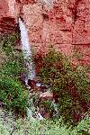
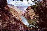
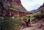
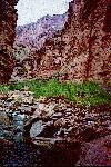
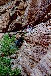
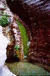
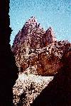
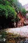
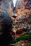
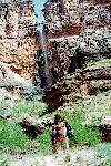
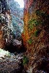
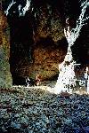
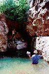
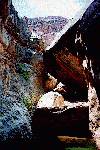
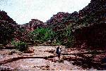
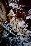
Day 1 - May 21 - Thunder River Trail on the Esplanade We left camp at 8:00 after organizing our packs. Oatmeal. We were through the difficult vertical stuff by about 9:00. It was pretty straightforward with little exposure. That left us on the relatively level Esplanade all day long. We joked that this was the Energizer Bunny Trail because it keeps going, and going, and going. Most of the distance is dictated by the need to skirt all of the tentacles of the Deer Creek Drainage. We stopped many times, and drank lots of water. We asked ourselves "what is it we forget from year to year?" How hard this is? How rugged it is in the Grand Canyon? How much water is required? How hot it gets? Jerry again showed his talent at locating shade in the desert. We finished the day at the edge of the Esplanade overlooking Surprise Valley. The last few hours of the hike were made interesting by the shapes the eroded Esplanade takes on; hamburgers, flying saucers, meatballs, oreo cookies. After we set up camp, a group of 4 hikers selected a camp site just below ours without probably knowing we were there. They must have been coming up. We had just enough water for supper, breakfast and to get to Thunder River. We gladly ate one of our MRE's. They were the heaviest suppers we had. They got rave reviews all around, except for the fruit, which was pretty tasteless. We retired at 8:00 when it became dark, and slept under the stars. Day 2 - May 22 - Thunder River and Deer Creek Granola. While eating breakfast we were again struck by the number, variety, and beauty of the flowers in and around the camp site. The descent do Suprise Valley was reasonably easy. The trail was well travelled. We were in the shade most of the way. As we descended we could really see the angle of repose of the rock in Suprise Valley and we could see how the slump theory had come about. It really makes sense when you see the rock in the valley. We stayed on the Thunder River trail until it met the trans Surprise Valley trail. We went off the trail a little and dropped our packs in a dip, behind a bush. We took Mr. Bucket (foldable, fabric) and several water bottles, and our soap. Without our packs the trip to Thunder River was a breeze. We heard the falls before we could see them, and even though Jerry and Norm had seen the falls in 1994, everyone was impressed with the amount of water which comes out of the rock at Thunder River. We went down below the head of the falls just a little, where we could snag buckets of water for bathing, and to take with us for drinking. We were in the region where the spray falls, so we remained cool even though we were fully in the sun. We had Thunder River to ourselves and stayed for about an hour. The hike back to the packs was tough at the start due to the steepness of the trail just above the falls, but it gets to be downhill into Suprise Valley. Putting the packs back on was an unpleasant shock. We only went about 30 minutes before stopping for lunch. John realized to his horror that he had bought cans of tuna instead of chicken. The dominant labelling said Breast of Chicken, but this was the brand name for the tuna. The climb out of Surprise Valley was easy but the descent into Deer Creek was quite challenging and a little exposed. The books don't give any clues about the difficulty of this descent. The trail is quite rugged, loose in some places, and involves a talus slope. It goes by one of the major springs which makes Deer Creek. It has a mini version of Thunder River. As we hiked down into Deer Creek, we were met on the trail by a rafter. She said we would be to water in 20 minutes. 10 minutes later we met another rafter who said we would be to water in 30 minutes. I think it was more like 40 minutes. After the "hairy" portion of the trail was done, Norm broke out the Pringles for the first time. Eventually we got down to the valley about a mile above the narrows. We looked for a good camp site, but they were occupied, so we went right into the narrows to enjoy the water, and the cool. We waded and dipped in the Jacuzzi, and after Jerry got the sandals, we waded downstream as far as we could. We spent an hour or two and then put our packs back on and headed for the river. We talked to a party who had come down the Thunder River trail in a single day. They were so tired, they were still there three days later. They thought we were just going down to the river for a look, so they told us we'd better leave our packs because there was a place which would be too narrow to pass with the packs on. Norm explained that we were going not only to the river but on down the river to Kanab Creek. One of the party said we were an inspiration. Norm forgot, but Jerry remembered the narrow place to which the person was referring. Jerry and John had been duck walking and crawling to get their packs under some overhangs where the more typical move would have been to sidestep along a ledge. When we got to the narrowest point it was impossible to use the crawl, so after Norm went past he took off his pack, and returned to assist. Jerry and John took off their packs and eventually Norm determined that the ledge was wide enough to slide the packs on their sides. Jerry wasn't sure if Norm was just figuring out a way to do it or maybe had "lost it" in a tight place. After this moment of excitement we worked our way down to the beach. We arrived at about 5:30. It wasn't obvious even from the higher point of overlook on the trail where the next piece of good sand might be, so we elected to camp right near the falls. As we set up for camp, the boaters party trickled past. Eventually the woman who had said 20 minutes arrived and apologized. Norm asked the leader to hug river right in the morning, and throw us a couple beers. He laughed but then brought 2 back to our camp. The boaters camped across the river. We ate En chilada, Dinner #1. Tasted fined. Day 3 - May 23 - Breakfast Rock/Lunch Rock/Supper Rock We started without breakfast to get an early start and clear out of the camp site. We were now seriously dependent on the Loop Hikes book. After about 30 minutes of walking we were on what we thought was the "broad beach" and we stopped to have breakfast on top of a rock. We misconstrued a couple of land marks for those referenced in the book and got totally side tracked high up a talus slope which was made up of loose rocks and no good way to climb. We spent about 2 hours trying to figure out how to contour down river above some Tapeats cliffs. We found a rough trail, but it stopped dead after a few dozen yards. We couldn't figure it out, but we all knew what we were doing was not fun. We decided to go back to the spot where we had eaten breakfast, and talked about trying to get a ride on a raft. Jerry and John rigged a tarp to give us some shade using two of the walking sticks. We ate lunch, drank lots of water, rested, and eventually began comparing what we had seen and done to what the book described. John observed that we normally overestimate the distance we have covered. Jerry suggested that maybe the Tapeats ledges from the book really were there, and we just didn't look for them. This all started to make sense, so after a little more rest, Jerry and Norm went back down river to see if we could get through after all. They found the correct trail, followed it across the ledges, across the broad beach, and up over some of the Tapeats cliffs. They returned with good news to John. We all agreed that in the morning we would head out as planned. We had stroganoff and blueberry cobbler for supper. It was good. After super we watched some suckers swimming near shore. Jerry tried to feed them blueberries. Although John and Jerry had fishing rods, there was no fishing attempted (on this or any other occasion). It was quite cloudy at sunset. Would it rain? Norm slept about 20 yards down the beach from the snoring. The rafters across the river, were entertaining with native american drums. It was hard to get to sleep. It didn't rain, so we were able to sleep under the stars again. Day 4 - May 24 - Raft ride and Kanab Creek Granola. We set out to actually do the route described in the book. We successfully negotiated the Tapeats ledges and Jerry was sitting on the broad beach changing into his shorts as Norm and John joined him. John and Norm waved at a couple motor rigs, and all of the sudden, the second one turned around and came back towards us. The boatman asked if we would like a ride to Kanab Creek. We said we certainly would, and jumped on board. If we had arrived at the beach 15 minutes earlier, we would have been up the trail, and would not even have been seen. Norm learned from the passengers, that the boatman, had been brushing his teeth and had stopped and said "This is no good. This is no good. I can't do it. I can't do it. I just can't let those backpackers walk all the way to Kanab Creek." The passengers thought something was wrong with the boat or his teeth or something. We rode in the raft for about 30 minutes and the longer we rode the more grateful be became for the ride. We agreed afterwards that it would have taken us most of 2 days to hike that stretch. The boatman also gave us the valuable advice that to complete the trip in 4 days we would have to "make our miles" each day. After the boatmap dropped us off, we started up Kanab Creek. We were feeling great and feeling like we were now ahead of schedule so we stopped for a cup of coffee. There was also a rafting group walking up to see the slide spring. Following all of their footprints made the route finding pretty easy. The creek bed is all cobbles or boulders so the walking is not easy, and takes quite a bit of concentration. As predicted by the book there we two long Muav ledges which made the walking easy for a few minutes at a time. We also had lunch on a more narrow ledge. We had to cross the creek many times. We attempted to cross on rocks, but eventually all six of our collective feed were wet. We saw our first snake today. It did not rattle, and eventually crawled off the trail. Today we became concerned about making enough miles to get out in the allotted 4.5 days. It seemed to take forever to get to the slide spring. Perhaps it was because there were no intermediate goals? By the time we got to slide spring, all the rafters had met us on their way back to the river, so we were alone. We found a nice camp site under some Muav ledges. These provided some shelter from the drizzle and many shelves for our stuff. We heated up some soup before walking up to the spring. The walk to the spring took only 15 minutes without packs, one of the few times we met the schedule which was noted in the book. The slide spring is a very pretty sight; sweeping curved water slide, lots of maidenhair fern, clear pools. We were too cool to bath or dip. It drizzled and rained all day. We tried rain gear once but then it let up right away. We next tried to find overhangs during the worst downpours. During one break under an overhang, Norm noticed how good the echoes were. He could count to three before the echo came back. It was at this stop that Jerry coined the now infamous "It couldn't be too far to _______." phrase. Also while under that overhang, some rocks came loose and fell not far from us. We vacated very quickly. Once we prepared supper, it began to rain steadily. We had our last MRE's. Rave reviews again, with beef stew and baked beans getting special mention. We played trivia until it was too dark to read. Norm kept scrunching his feet under him to keep them dry. We set up the tents between showers, but by 9:30 there were stars in the sky again. Day 5 - May 24 - Scotty's real and false. Oatmeal. Today's goal: reach Scotty's castle and go beyond if possible. We awoke at 5, were on the trail by 7:20. We quickly decided that we must wade and stop trying to find places where we could cross on dry rocks. This saved some climbing, and backtracking, and improved our speed. Jerry's boots were waterproof which was great until the water came over the top, then just as it had not come in, it could not get out. He eventually switched to his Tevas. Intermixed with the gravel and wading we occasionally had to climb over massive boulders which filled the bottom of the gorge. The water in these places was forced into deep swift channels with frequent little falls, so we had to find ways over the tops of the boulders. This was time consuming and tiring. We passed our packs over a few of the worst or tightest places. We identified the 'false' Scotty's castle and by 2:00 we were napping at Scotty's grotto and looking forward to doing a few more miles. Soon after Scotty's we saw the clear prints of a horse, mule or burro. This seemed to indicate that the bolder scrambles were over at least temporarily. Following these prints was quite easy. After Scotty's we reached the hanging spring. The outcropping completely crosses the creek, and it is dripping all over the bottom of the outcropping, which is covered with ferns and flowers. We stopped here for a long rest. At this point we were just about out of the Muav, and the top of the Temple Butte didn't seem too far away. We had "made our miles", gotten to and past 3 land marks and were feeling pretty good. We found a nice camp site in an open valley, and set up. We had mashed potatoes and beef gravy and peas and banana pudding tonight. It was great! Best so far. Played trivia until dark and we were set to sleep under the stars, only there weren't any. John suggested we had better set up the tents before it rained, and about then there was a thunder clap. We set them up as soon as we could. It rained for an hour or more. Day 6 - May 25 - Illness & Waterfalls Woke about 4:45 but Norm felt dizzy and nauseous. He did some elimination chores, and Jerry and John made him a cup of tea. Jerry had folded up the tent and was working on the sleeping bag, but Norm asked him to hold off on that. After drinking the tea, Norm went back to sleep. John and Jerry went for a walk up stream while Norm slept. About the time they returned, there was a loud thunder clap, and Norm decided that he must get up to keep his sleeping bag from getting wet. He got his bag put away and one sock and boot on when the rain started. John was covering his pack with his tarp, and just opened it up for all of us to sit under. We were huddled expecting it to stop, but the longer it rained, the more spread out and comfortable be got. By the time the rain slackened, Jerry couldn't stand it under the tarp anymore so he crawled out. He pulled the tarp off of Norm and John to show them that one of the run off's in the red wall had started a water fall. It was beautiful. As we watched it, the rain started again. This time we headed up to an overhang. We huddled there and stayed quite dry but John noticed that a major chunk of rock had recently fallen from the ceiling. When the rain slackened again we crawled out. A third time the rain picked up and we jumped across the creek and found refuge under an very sturdy Redwall overhang. When the rain let up this time, we saw a second and more spectacular waterfall start up. The flow was much stronger, and this one fell in stages, punctuated by pools at different levels. We heated water for coffee, and watched the water falls. The sun came out for real this time, and we headed up stream. This rain delay provided the necessary time for Norm to recover from his bug. Norm had been the only one to drink directly from the hanging spring. Could be where he got the bug. The creek was at least twice as high as it had been before the rain. It was also quite muddy. We saw four more water falls as we walked. We filtered water from one of these, since it seemed cleaner than the creek. Again we were able to follow the horse/mule/burro tracks. Just below Jumpup Canyon Kanab Creek went dry. All of the water in it had been coming from one tributary. Having the creek dry made it a little easier to walk. We reached the Jumpup Canyon junction about 4PM. As we sat in it resting, we heard water sounds up Jumpup Canyon, which was bone dry. As we watched, a flow of water came down the bed and continued to flow until after we went to bed. It was dry in the morning. There was a nice camp site at the junction between Kanab Creek and Jumpup Canyon. We wanted to make a few more miles, but were concerned that there might be no decent sites inside Jumpup Canyon, so we decided to stop for the night. (A wise decision, as there are no good spots in Jumpup.) This gave us a few minutes to catch up on the log, shave, clean up, etc. As we cooked dinner we emptied the first of the three LP gas bottles. Slept under the stars again, even though we had the tent up just in case. Day 7 - May 26 - Jumpup Canyon, the Obstacle Pools On the trail (or in the creek bed) by 7:00. The walk across Jumpup Canyon was straightforward cobble walking. Indian Hollow started out the same, but as predicted by the book, within 15 minutes we got to the first obstacle pool and chock stone. Norm and John swam across the pool, while Jerry got ready to tie the packs onto the rope for lifting. John helped Norm get on top of the chock stones, and Norm went off to find a good place to pull up the packs. He tried the right side, then switched to the left side to allow the lift to be made from dry ground. There was no good way to get to the necessary point on the left though so he switched back to the right. Once he got to the lifting point, Jerry and John suggested floating the packs across on their inflatable mattresses. Norm said he thought this was fine, and returned to the chock stones. Jerry placed the items on the mattresses, and pushed them over to Johnny, who unloaded them and tossed or lifted them up to Norm. It took 5 or 6 trips, but everything stayed dry. Jerry swam across, and he and John climbed up the smooth chock stone unaided. We reassembled our packs, and put our hiking clothes back on. As predicted by the book, we reached the next pool within a few minutes. This one was smaller and only chest deep. Norm waded across. Jerry handed the packs to John who waded a few steps and handed them to Norm who stacked them on dry ground. This only took a few minutes. The final chockstones were enormous, but there was no pool. John found a way to climb through, and we handed the packs through the hole. This morning was marked by excellent team work with the packs and with pushing and pulling each other through tight places. We had lunch under a cottonwood tree next to a small pool from which we got water to filter. (Mr. Bucket was nominated for rookie of the year gadget. It came in handy on so many occasions in getting water, and cleaning up.) The afternoon was beautiful working through the last of the redwall and most of the Esplanade. The water was flowing in the creek all the way and there was lots of plant life including many full sized trees. We saw another snake today. We changed our route to accommodate it. Most of the walk was right up the creek bed with some stretches of sandstone "benches". We had to go high once to avoid one last chockstone. One challenge of the day was to ensure we didn't get out of the Indian Hollow into one of four minor washes. This would have resulted in just turning around and wasting time and effort. John did an excellent job of using the map and compass, and reading the terrain to see that we made our left, two right, and left turns at the right times. Near the end of the afternoon we located several flat spots on the sandstone, and selected the best one for our camp site. We had Macaroni and Cheese with some of John's tuna and the green beans. Jerry made apple compote for desert. We all agreed this had been the best day of an excellent trip. Norm suggested his changing point of view. He had originally looked at the rests as necessary to allow the walking. Now we was thinking that the enjoyment was greatest during the rests, and that the walking was necessary to get to different rest places. Slept under the stars again. There were a few sprinkles, so Norm joined Jerry, and John under the overhang. The tree frogs were in a romantic mood and kept calling to get a date. This made it hard to sleep. Final day - May 28 - Hermit boulders, and Three Phases of Coconino After the restless night, we arose before 5 and were on the trail by 6:50. The first section was more Esplanade and a nice gravel bed. We worked our way out of "hamburger land" into a more classic Grand Canyon desert land scape in the Hermit Shale. We worked our way up Indian Hollow behind Fishtail Mesa. As the book predicted we eventually encountered huge boulders, at the top of the Hermit Shale. Climbing over these required lots of work including going up the sides of the wash to contour around above some of them. Jerry saw our last and largest snake on one of these trips. Again we changed our route to accommodate. Half the battle in this part of the route was in fighting the bushes and grass around the boulders. They held us back as much as the rocks did. They did provide firm footing though as they held the soil from being loose and gravelly. We overcame the boulders and next met the Coconino. The Loop Hikes book said this would require 45 minutes and would be done in three stages. These was a Maple glade as noted and in fact the growth was so thick we could barely get through. John found the stage 1 notch on the left. We dropped the packs at the bottom of a small water fall, which was now just a few drips. John climbed up and searched for a place where he could raise the packs with Jerry's rope. The only place which would work was right above the waterfall. This required John to climb DOWN at tree into a glade. He wound the rope around the limb of a tree, and lowered it down to Norm, who tied on each piece of the load. The whole packs were too much weight to handle in one load, so we broke the packs down a little, taking off the outside attachments. Norm pushed with a Y shaped stick as John pulled. John suggested to Jerry that a "man's" rope would give a better grip. The parachute cord was strong enough but tough on the hands. When this lift was done Norm started up toward the notch. John shoved a broken li mb out of his way, and Norm thought the sound was coming from the limb falling, so he vacated the area at lightning speed. Once everything was up into the glade, we still had to lift it up to the main trail where Jerry was stationed. John moved all the stuff to the base of the tree he had climbed and Norm came up the notch and back down to a sandstone ledge near the tree. Jerry threw the rope down to Norm, who threw it down to John. John tied each piece on, and Norm and Jerry pulled it up. Norm's job was to see that the pieces made it by the ledges and rocks. This he did with his feet and hands. It required that he slide up and down the ledge once for each piece. The ledge got slipperier each trip, and Norm got more nervous on each trip. When all loads were complete, John climbed back up the tree. We rejoined our stuff on the main transition trail between stage 1 and stage 2. Norm went ahead to see what stage 2 was like. He reported that we could get to stage 2 with our packs, but not up the chimney with them. (The book says that the chimney can be climbed with packs on. We'd like to see video tape of that!) We put our packs back together, and climbed past the exposure to stage 2. We had about 12 square feet to share at the bottom of the chimney. John dropped his pack and climbed first. Jerry went about half way, and they tried to develop a strategy to again raise the packs by the rope. Eventually John found a place to sit, where he could drop the rope to Jerry, who could drop it to Norm. We broke the loads down even further this tim e, with the water being the heaviest. We even emptied the heaviest items out of the packs and made them separate loads. It was interesting to observe how we each got comfortable in our precarious positions after a little while. John got the scare of the trip when Norm let out one of his high frequency sneezes (complete with excellent echoes). John thought he had fallen for sure. As Norm climbed up the chimney, he took the liberty of cleaning out all of the loose rock to be sure he had good footing. The last move at the top took a little care and thought. After repacking again, we moved on to stage 3. This was interesting but did not include any exposure. We were blocked by a chock stone again. One route was up the side of the wall with a tree blocking the top. The other route was up under the chock stone, with a tree branch to give one a starting point. We took our packs off again, and Norm tried the tree route. He came around and down to the top of the hole where John and Jerry pushed up the packs. John then helped Jerry up through the hole. There was about no room to stand because all of the packs were there, so Jerry kept going up two more small climbs. John came up to the packs last, and handed them up to Norm, who handed them to Jerry. Finally we were actually done with the three stages. It had taken about 3 hours to do this 45 minutes of the route. We had completed the Coconino in about 300 "map" yards. Normally this takes repeated switchbacks. There was plenty of adrenaline pumping and we wanted to be sure we were through the Coconino for good so we did not stop for lunch until we had pushed through the waist high brush in the Toroweap for about a half hour. Norm broke out the Pringles again. We discussed options ranging from camping ASAP to getting back to the car,, and then driving to the Norm Rim Lodge area that night. We pressed on taking breaks as often as every thirty minutes. The brush was tiring. Soon after lunch, we saw cattle prints. We took this as a good sign that we were done with climbing walls, chimneys, or boulders. As we wound our way up Indian Hollow, the brush thinned, and the walking became easier. At last we climbed up the side of the wash to find a trail, a familiar trail, the trail we had started on. We took it to the rim. We took pictures with all but the last exposure. We enjoyed the view from the setting sun andwalked slowly into the campground. We enjoyed the horizontal picnic table, and benches, and even the outhouse. Our left over food amounted to 2 cans of meat, one granola bar, about 3 ounces of Jerky, half a jar of Peanut butter, and 8 crackers. |
|
| |
| |
| |
| |
| |
| |
| |
| |
| |
| |
| |
| |
| |
| |
|
|
|
|---|
|
|---|