|
Tonto and Grandview Trails, August 1994 |
|---|
OK so I’ve waited the requisite 23 months for my reservations at Phantom Ranch (at the bottom of Grand Canyon) and I am now ready for my first rim to rim hike in mid September 2005. (For the record I understand they have now changed the time to a maximum of 13 months advance notice)
I’ve read many trip reports and I always like to know a few details about the author so here’s my background. I am 52 years old and have hiked to Phantom many times but always before leaving from and returning to the South Rim. I would also add that I am closer to novice than a real hard-core desert hiker. If I could lose 10-20 lbs I’d be at my ideal weight. Perhaps at 6 feet I am just too short for my weight. My pre-hike workout regimen consists of walking two miles 6 days a week and riding a stationary bike 3 miles a day 5 times per week.(walk year round, bike 3 months prior to hike) I know this is not all that much but it works for me. I also thoroughly enjoy being in Grand Canyon and it is my firm belief that stronger the desire to hike the canyon, the greater the energy level.
I have always hiked alone (except for once when a buddy went with me) because I haven’t been too successful at finding a good hiking partner. (I’ll also admit I don’t look real hard) My wife won’t / can’t go but fortunately says it’s OK for me to go. “Have fun” she says, “see you when you get back”. What a great woman! Also let’s face it, hiking Grand Canyon and all it involves is not most peoples’ idea of vacation. OK enough of the boring disclaimers now on with the story. Oh yeah, one more, if by some chance this is still floating around the net several years from now and you find some of the things I’ve mentioned are not the same, keep in mind that as Walter Cronkite would say, “and that’s the way it is, September 2005”. OK, if you haven’t nodded off yet here goes.
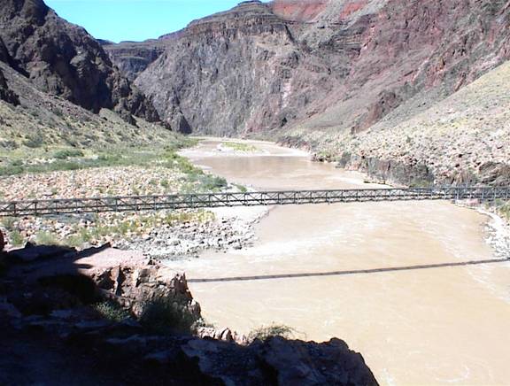
My story starts with a ride on the Trans-Canyon shuttle leaving the south rim about 1:30 pm. This day there were three buses with about 11-12 people in each. If ever the saying “you can’t get there from here” applies, it applies when speaking of traveling from rim to rim. Even though as the Raven flies it’s only about 10 miles across, it is over 200 by car. The (5 hour) ride itself was fun in that there were friendly people on board and everyone swapping previous hiking / camping experiences. I think everyone on the bus was going to hike back to the south rim. Perhaps the most interesting person was a man named Maverick ? (sorry didn’t get his last name) who was also hiking rim to rim. Mr. Maverick is not your usual hiker. He is 79 years old and was making his 40th something r-t-r hike this year! Not only that, but on this trip he left as soon as the bus arrived at the trailhead, (about 6pm). He prefers to hike at night but I’m not sure why. Not only that, he does not stop at Phantom. Like that pink battery powered rabbit on TV he just keeps going all the way to the south rim! I have never been in good enough shape to make a non-stop r-t-r crossing so I tip my hat to this man. Mr. Maverick is proud of his physical condition and will not hesitate to tell you what great shape he’s in. He said he can leg press 600 lbs! Also apparently he and his doctor are writing a book about him.
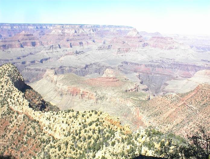
The scenery enroute is worth the trip alone. You leave the south rim and drop down into much hotter desert land then eventually work our way back up to the high ( approx 8500 feet) forested and cool north rim area. On this day I do mean cool. Think 40şf. It seems most days on this trip my day swung from a high in the 90’s to a low in the 40’s. This makes planning what to carry in your pack all the more fun.
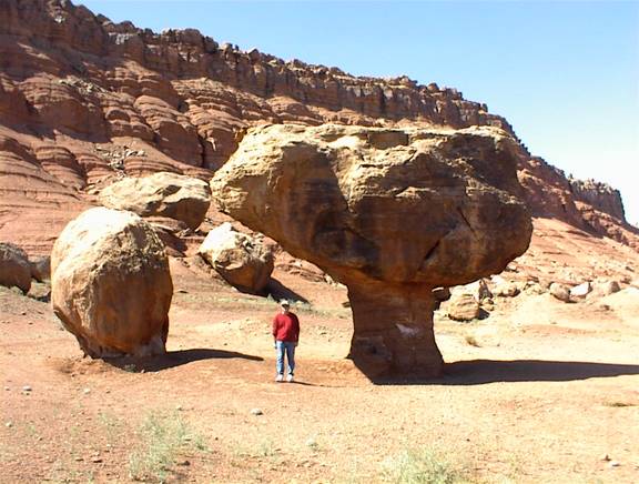
A fun quick stop along the way was at these huge suspended boulders. These rocks fell down from above then wind etc. eroded away the pedestal. I went back here later and took this picture. I asked a very friendly Navajo lady that was there if she had ever seen a rock move. “No” she said, “Nor has any elder I know seen one move”. “If they ever do, it will be a bad omen for the Navajo Nation”.
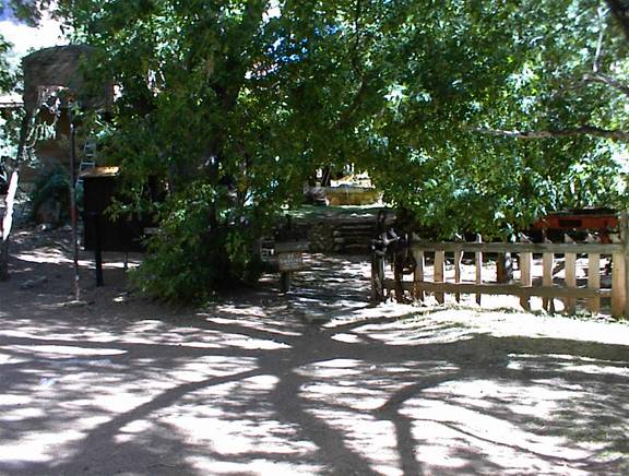
On to the North Rim. As mentioned we dropped off Mr Maverick at the trailhead then on about two more miles to the lodge. How different the North Rim is! Everybody said it was little like the South rim and they are right. Here there is only the lodge and no other places to stay or eat at all. Picture it as a place with a 50 mile long driveway. For dining you make reservations far in advance for the main restaurant, eat at a little deli place called the “deli in the pines”, bring your own, or drive about 100 miles round trip. The area is heavily forested here unlike the South Rim which has much more open space.
After a mostly sleepless night in the motel portion of the lodge I was up a 4:30 for what would be my longest hike ever. Could I go the 14 miles to Phantom? I knew I could but had little idea how long it would take. I will be going twice as far as the South Kaibab trail I usually take.
Fortunately the saloon adjacent to the lodge opens at 5:30 am. It’s not that I needed a drink, but they have COFFEE and fruit, bagels, rolls etc. There was enough to make a good breakfast. OK so I am now ready to go. “How do you get to the trailhead?” I asked some obvious other hikers. They paused for a moment , looked at each other then back at me and one of them said “you walk”. “Oh , I thought maybe I could get a ride”. They just smiled and so did I. OK so I’ll walk. What’s another two miles on level ground going to hurt? Off I went down the trail called the Bridle Path towards the North Kaibab trailhead. It was COLD! Deer looked at me in the early dawn light as if I was slightly nuts. Maybe so but that’s none of their business. As I walked I began to huff and puff like I was just finishing a marathon. What’s wrong I wondered. I thought I was in better shape than this. Then I remembered that I was now about 10 times higher altitude than my southern Michigan home. I hope it’s the thin air I thought, I have a long day ahead of me to be winded now. Finally I start down the trail. How different than the south rim in that you start through forest for the first 1-2 miles. Also just like everyone told me you go DOWN a lot fast. As I walk I marvel at the trail. What a monumental feat to blast and carve all this solid rock. Also how did anyone manage to lay it out in the first place? I work with tools and machines and I know that rock cannot be moved without heavy machinery. How did they get it here? I know the CCC did much of the original work but still it had to require amazing amounts of human strength to get the job done. All the required heavy machinery would have to be carried in. What hard work! A park ranger I was talking to later about this said she thought people in general were much tougher and stronger back then than they are today. I think she’s right.
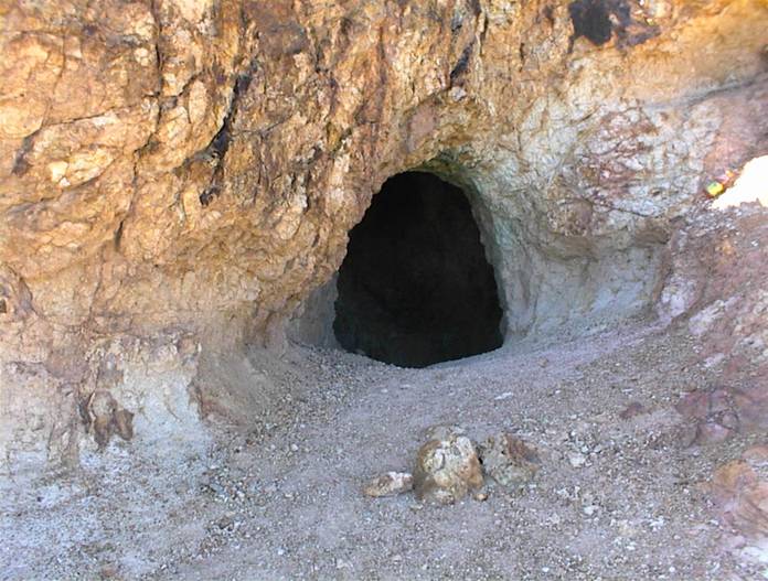
Soon I arrive at the Supai tunnel, 1.7 miles below the rim. Here there is a short cave blasted out of solid rock. There is water here but I don’t need any. About 3.7 miles total so far and I’m feeling fine. Still I haven’t sat down yet and am eager to see what’s around the next bend. A young guy about half my age waved as he literally ran by. What’s his hurry I wonder?
This reminds me of the old “road runner” cartoons. |
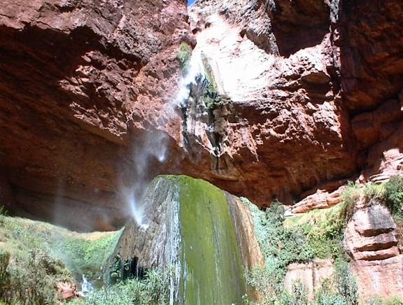
Soon I hear the sound of what I assume is Roaring Springs and before long I’m there. Here is massive amounts of water pouring out of a hole in the wall! From here it flows on into the canyon to start Bright Angel Creek. It’s good to know plenty of water is nearby if you need it.
On I go. I remember thinking I’m making good time at this point and perhaps I should slow down but I am on a roll. Shortly after this I am at Aikens house. For those who don’t know, a family lived here for several years. Bruce Aiken took care of the pump station and I understand he and his wife raised their kids here. I have seen them on TV on the travel channel.
My feet are starting to hurt a little now but overall I feel in great shape. The weather is perfect. In fact the sky is cloudless and Phantom only got up to the low 90’s while I was there. It is the coolest weather I’ve ever had here. It can still be over 100 at the bottom even in September.
Soon I arrived at Cotton wood campground. Many stay here on a North Kaibab hike as it is roughly halfway to Phantom. As for me I am much too lazy to carry all that camping stuff but I’ll have more to say about that later. At Phantom there is a hot shower, someone else cooks a great meal (and cleans up) and there is a cushy bed in air conditioned comfort to sleep in. Also you don’t need to be too concerned about scorpians in your bed, as you do when camping. Most folks would rather not have one in their sleeping bag.
I sat at a picnic table for a while resting my tired feet, drinking water and eating crackers. I saw no one around although a tent was pitched nearby. Soon I headed on down the trail. I knew it wasn’t far to Ribbon falls and I wanted to take the detour to see it. I had been here once before on a day hike up from Phantom but that was about 15 years ago. It hasn’t changed.
As mentioned you have to detour off the NK trail to get here but it’s worth it. I sat here for a long time. No one was around at all it seemed as I sat soaking my feet in the water under the falls. Did I mention they hurt? All at once I turned around and there stood a park ranger. “You OK” he asked? Sure I said and we talked for a while. I have never met a park ranger that wasn’t a pleasant person to be around.
OK put the socks and boots back on and head toward Phantom. I think there is a trail here that goes on South and links back up with the North Kaibab but I can’t find it. Oh well, back to the north cut off where I came in. It really isn’t that far and I’ll know if I go back to the start and resume I’ll have walked every bit of the NK trail. For some reason this seems important.
Now the trail is mostly level but I still have about 5 miles to go. In another mile or so some people point out a Big Horn sheep high above us on a ledge. We can just barely see him since he is young and small. His big horns really aren’t that big so I still have never seen a big horn sheep that really has BIG HORNS. I’ll keep looking. Finally I come to the box (sorry I didn’t take a picture) and it as always very HOT here. I wonder if it’s still hot in the winter? Next I see Phantom Creek coming in from the right and I know I have about 1.5 miles to go. I hiked way up this creek many years ago and felt more ALONE than any other place I’ve ever been. Surely others have been here but it seemed at the time like no one ever had. By the way my feet still hurt but not unbearable, must be the Extra Strength Tylenol holding back the pain.
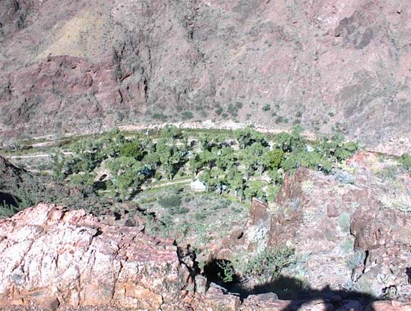
Next is Clear Creek trailhead and then finally I’m at Phantom. Did I mention my feet hurt? I looked at my watch; 2 pm it read. Not bad I thought. I figure from the lodge to here and the Ribbon Falls detour I walked about 17 miles in 8 hours. Slow for many I’m sure but pretty good for me. The thermometer here reads 92ş. OK watch out I’m headed for the canteen. I know that just inside the door will be ICE WATER and I want some. After a couple cups I get in line at the counter because next I want two things. First I want a cold Tecate and then I want to check in. Two people are in line ahead of me. The first is arguing with a polite young man behind the counter about the guy in the cabin next to hers. Seems he’s playing music too loud and she wants him to go put a stop to it. He says, “you tell him”. She says “no you tell him!”. After going around in circles I politely offered to shoot the offending party. The idea was quickly accepted by all none of us had a gun. Oh well we’ll just have to figure something else out.
The next person in line wanted to know what kind of ice cream she could buy. “Sorry lady” came the reply. “We have no ice cream. Never have had it here, never will. We have no way to get it here” Do you know where you are I thought to myself?
FINALLY it’s my turn. “Tecate please! AHH Thank you. Oh yeah, I need to check in too, here’s my receipt.” I don’t know how Tecate can fix your feet but it DOES! Think I’ll have another.
Next I’m off to my dorm and a shower. After that I am refreshed and ready to head off for the afternoon ranger talk. Today it’s called “ask the ranger”. People gathered and started to fire off questions. I thought to myself that I know the answer to about ľ of these questions. Either that must mean I’ve been here too much, or not enough? I’ll have to think on that.
After the usual great meal I went to the evening ranger talk about the triple C trail builders. I learned a lot about a subject I had been wondering about all day. Soon after this I turned in at the dorm for some much needed rest. Don’t forget your earplugs if you sleep here, other guys snore!
Next morning I’m up early. (maybe because they wake the dorms up at 4:30 am) After “pigging out” at breakfast I’m off for Clear Creek Trail. This is a great day hike and I got to see many interesting things done by the triple C guys pointed out by the ranger the night before. I’m glad I went to that talk or I wouldn’t have known.
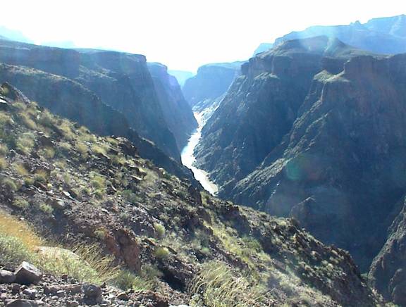
I continued on about 5 miles back this trail and got some beautiful views up the mighty Colorado.
After spending many hours on this trail I made my way back to Phantom where I then headed down to the river. I always visit the Indian ruins, and I wonder what life was like for those who lived here. Also nearby is Rees Griffith’s grave. He was killed here while building the black bridge. Most walk by without noticing. Next I have to do the two bridge loop.
In the late afternoon this day two mule wranglers put on a concert. One named Dusty picked up his violin and played Mozart’s (A Little Night Music) for “warm up” he said. They both were excellent entertainers. For a closing number they played and sang “Mama Don’t Let Your Babies Grow Up to be Cowboys” while two couples got up and danced on the hard gravely ground. I have never seen anything like this before at Phantom. It was great fun!
This evening is another great meal at the dining hall. As I look around the 50 or so people present I notice that I am no where near the oldest in the group. Many people in their 60’s and 70’s make the trek. Later the evening ranger talk was about bats. I didn’t expect it to be all that interesting but it was good. I learned a lot about these winged critters.
The next day I’m up for the early breakfast and ready to head up the Bright Angel. After the long North Kaibab I now think the very steep South Kaibab (only 7 miles) looks easy. Should I go up it? Naw, why push my luck. At first light I’m on the way. It is a fairly easy hike to Indian Gardens and I made it in about 2 ˝ hours. One thing of interest I noticed that I had not seen before is that near the top of Devil’s Corkscrew you can see the remains of an old trail. It is off to the west or on your right as you’re going up. I have read that the trail used to be much steeper here so I guess this must be that old trail.
After some R and R at Indian Gardens I am ready for the hard part. For those who don’t know the last three miles are the most “fun”. Here it’s 3000 feet of UP in three miles. This day the weather was great and I felt good so I made it to the rim fairly easy in 7 hours.(after leaving Phantom) Once again I know that others can do it much faster but this is a good pace for me. Besides, if you get to the top too early and you’re staying in the hotels your room won’t be ready. I figure it’s better to be hot and stinky below the rim where it’s obvious you are a hiker.
There is this sad note to report. On the way up I see and hear a helicopter flying around various locales up and down the ledges. This went on most all day. Unfortunately when there are helicopters flying here it means trouble for someone. Usually it’s an emergency evacuation for someone injured. This is area is restricted to all other aircraft except the park service, so when you see one, it has to be them. This day they are searching for an overdue 46 year old man. As of this writing, (about 10 days later) he still has not been found. While searching, they found the body of another man who had not yet been reported missing. While on this somber note, I will mention that at every trailhead there is this poster.

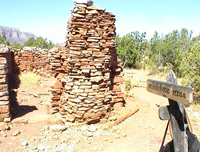
The next day I decided to “day hike” to Horseshoe Mesa. By the way, I ask the reader if you use the web site
http://earth.google.com. If you are not aware of it is a great way to actually see the terrain of the Canyon. Also all the rest of the earth is there too. Sorry I digress here, back to the story. I drove to Grandview Point and easily found the trailhead and started down. I was amazed at how steep this is. It seems like you go down and down and down. After about ˝ mile along the trail I saw no other people at all. Also I didn’t see anyone on this entire hike until I got back close to the rim. As I went along I began to wonder if I should continue. Am I biting off more than I can chew? I am obviously aware that I have to make up the altitude I’ve lost and I wonder if I can do it. However I am curious about Horseshoe Mesa. I read that there are the remains of an old mining camp here. There are open mines, old equipment, and old buildings. I want to see this stuff and have come this far but still I wonder if I can make the return hike. It’s only 3 miles to the camp and 3000 feet down but this trail is much tougher than any other I’ve been on. I decided to cache water at the Coconino saddle. Was this a good place? I could only guess. Soon I saw a bench marker on a rock that said that it was some 1200 feet below the rim. Only 1200? It seems like 12,000 to me! After all that whining I am only 1200 feet down? I keep going. I could see the mesa down and out ahead but where is the trail?
I decide to press on. Soon I am climbing over under and around rocks. Where are the people I wondered? Am I the only one here? Being in this place I can see how someone can become lost forever. Down in the lower part one could easily stumble and go down into a ravine where I wonder if any person has EVER been. I am aware that it is somewhat dangerous to hike alone but it is a risk I am willing to take. I keep going and finally come out on horseshoe mesa.
(I’m thinking just a roof is all it needs, and maybe a refrigerator with some Tecate) |
(you can barely make out the green copper ore on the ground here) |
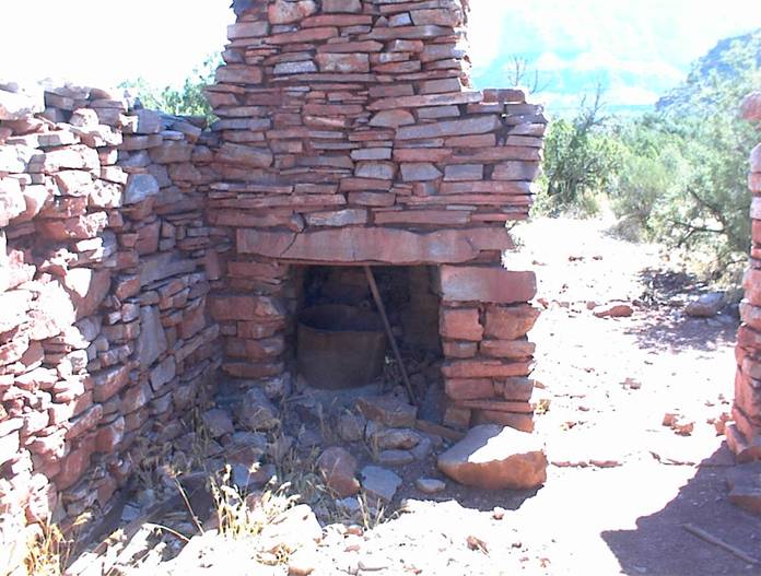
I spent about 1 ˝ hours here (in the area). There was a tent pitched nearby but no people around. Also there are many pieces of copper ore on the ground and various junk. Somehow this “old” junk such as parts of machines and very old cans is not that obtrusive. I would call it “historical junk”. It’s not as if careless modern day hikers littered the area.
Well I’d better start back up. This is a great place to see and I’m glad I made it but now can I get back up to the rim? In only about one hour I made it back to the Coconino saddle and found my water. I had worried a little that someone might take it but still I saw no one around. It turns out I had put the water in a good place because I was just about out. I would have probably been in trouble without it. After a rest I pressed on. In what seemed like a fairly short time I was surprised at how much ground I had covered. Also how anyone ever even THOUGHT about mining here is a mystery to me. I understand they hauled stuff in and out with burros but still it would seem incredibly difficult to me.
Once again I learn that going up is easier than going down. Before long I hear voices and then I see people. Soon after I am back on the rim. It only took about 2 ˝ hours to come up. Why was I so concerned? Afterwards I wished I had stayed down there longer. I think now I will plan my first back country overnight to Horseshoe Mesa. I want to see more there and walk out to the end of each arm. Late summer 2006 I plan to be there. I will look forward to it.
OK are you still reading? If so you are either goofing off at work or easily entertained. Now I have one more segment to my trip.
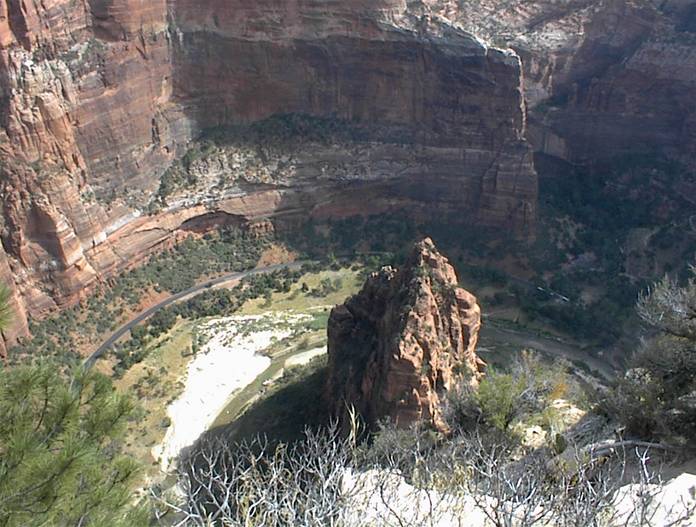
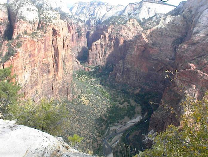
I went on to Bryce and had a great time there. Bryce has amazing hiking trails and is well worth the visit. From Bryce I went to Zion. I was told and I had read that a “must do” is the Angel’s Landing Hike. The signs say do not go if you’re afraid of heights. I had also read that on numerous internet sites. “How tough can it be?” I thought. “If anyone can do it, I can do it”. Here’s where you have to go, all the way to the top.
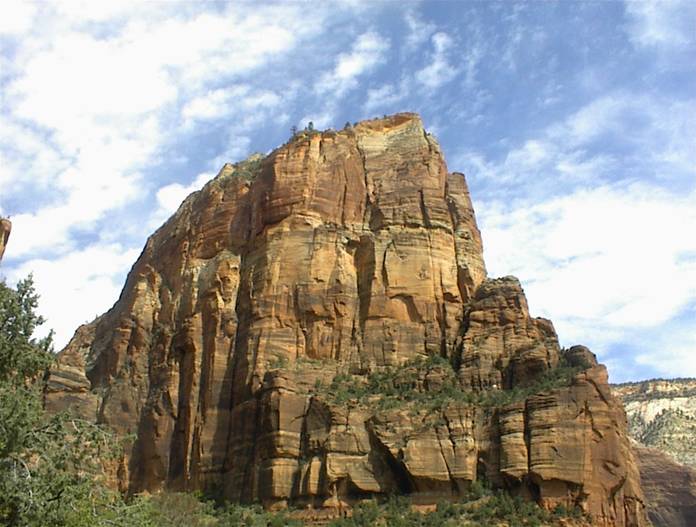
The Summit: The summit feels like the top of the world, although there are slightly higher cliffs visible in the distance. The views up and down Zion Canyon look on to an almost mythical landscape, with the river far below winding into the misty distance. The route to Angels Landing is rightly regarded as one of the most remarkable trails in the whole national park system. (The above is taken from a National Park website) |
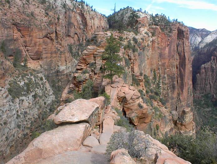
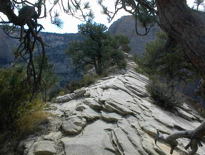
The path is only 2.5 miles long and is mostly off to the left (out of the above picture). The first two miles are easy. It is like walking up a steep sidewalk. Once again I am amazed at the work that went into building this trail. Who carried all that concrete up there? My back hurts just to think about it.
The last ˝ mile is the challenging part. I had read that you need to climb and pull yourself up with chains that are permanently installed for this purpose. This is absolutely correct.
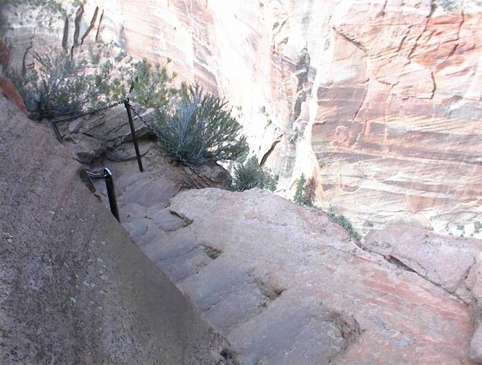
Here’s where I must admit great concern. This section really got my attention. For what it’s worth, I have piloted airplanes through loops, rolls and spins. I have jumped out of perfectly good airplanes, and I have voluntarily allowed doctors to suck a liter of marrow out of my bones as the donor half of a bone marrow transplant procedure. However I wasn’t sure if I could do this after I saw what was required to reach the top. “You mean they expect people to go up that?!!”. Here’s a picture of the first part.
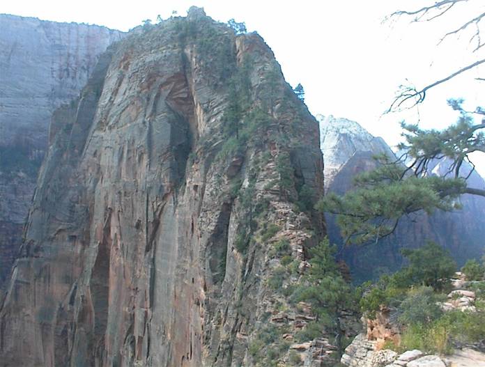
I estimate this part to be 300-400 feet . How could ANYONE go up that unless they were trained and equipped mountain climbers? Who would be dumb enough to try? Me? All at once two attractive 30 something ladies blew by me like I was standing still. Wait! I was standing still! What was their hurry I wondered? Is there a shopping mall up there? They quickly went ahead. A man nearby said he had come this far before and turned back. He was deciding if he should try again or not.
I decided to try it. To maximize my balance I took off my back pack and laid it on the ground. I can do without water for awhile and I don’t think anyone will bother it, I reasoned.
OK so I start up through the tight turns and bends and hang on to the chain with a white knuckle death grip. Here are a couple pictures of the really tight spots.
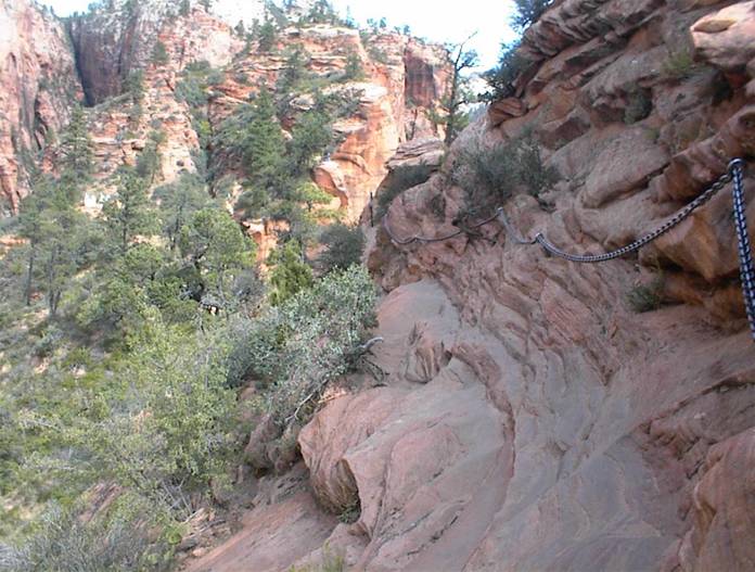
This area reminds me of a passage I once read written by a Grand Canyon mule wrangler. He wrote about a certain point at Grand Canyon that “if you fall off here, you would have time to roll a cigarette and get it half smoked on the way down”.
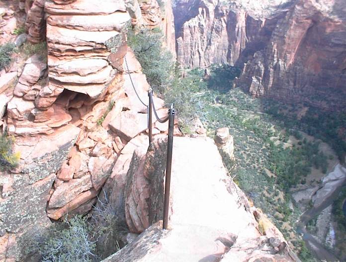
Ok I climbed and fretted over the sanity of this endeavor but finally I MADE IT TO THE TOP!!!!
Here’s proof.
I was glad I made it. Already here were the two 30 something ladies and about 4-5 other people. Soon the guy I had mentioned earlier that was struggling with making the climb reached the top. He was glad too. The terrific view that’s promised here doesn’t disappoint! It seems you can see most all of the Western Hemisphere from here. OK that’s an exaggeration but you can see most of Zion from here.
I stayed up here about an hour and marveled at God’s creation. WOW!!!! We sure don’t have anything like this in Michigan!
Well it’s time to head down. Oh yeah, I remembered I have to now CLIMB DOWN. This is one place where going down is definitely harder than going up. You learn very quickly to only look at what is directly in front of you and not off to the side where there are 1000 feet plus drops just a few feet away. (and just a few inches in some spots). Once again people are being very patient with others over who will pass at tight spots. No one needs be in a rush here.
Finally I am back down to my back pack and it is in tact. No rodent has tried to gnaw into my few remaining salty snacks. I worked my way back down to the “sidewalk” and now I can coast the two miles back to the bottom. What a hike. Yes, I WILL go again.
In conclusion I would recommend any of these hikes to those who like this activity. Just be sure to read and heed the information that you can so easily find on the numerous web sites. Just google up “Grand Canyon hiking”. Also I will add that I am very greatful God has given me the good health and the desire to do this.
Hopefully I will be back many more times. Mark, thanks for reading! PS, your comments are welcome!
Copyright © 2005, by Mark E. Boyer
|
|
|---|
|
|---|