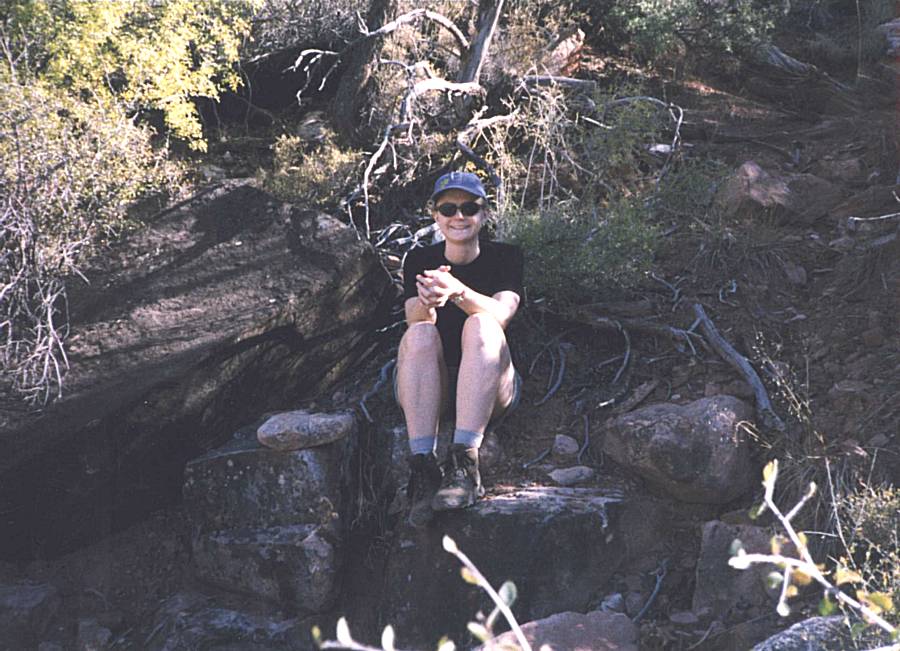
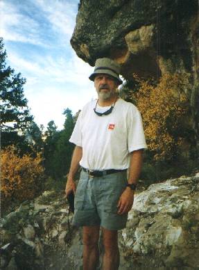
Chuck & Kristin Lindeberg, October 11-17, 1998
Grandview Trail, Cottonwood & Indian Gardens
This is a story of a trek into the Canyon that didn’t go as planned but was a great trip none the less. The plans that went awry were largely my own fault, owing to inexperience with overland, overnight backpacking trips of this length, and inexperience with the Grand Canyon environment. But a contributing factor was the itinerary given us by the Backcountry office, who, in their unfathomable wisdom, combined into one the two route options we had submitted as alternatives on our application. People more experienced with Canyon trekking, not to mention younger than my half of our party, would probably have attacked our route with relish. But not having that experience, and constrained by the limitations of having packed too much, we decided to play it safe and come out the way we had come in instead of following our assigned route across the Tonto Platform. If we had been confronted by a ranger on the hike out we would have pleaded that discretion is the better part of valor. Next time (and there will be a next time) we will have learned from our experience and will be better prepared.
As my three children were growing up I began taking each of them individually on camping trips, usually to the Boundary Waters Canoe Area (BWCA) wilderness here in Minnesota because it’s nearby. The opportunity for the one-on-one time with them was priceless and my only regret is that I didn’t do it more often and start doing it earlier. I’m fortunate that, even in their twenties, each of them still likes to get away with the old man for a few days when we can work it into our schedules.
Kristin and I had not gotten away together since 1993, when we went with some business associates of mine on a camping and caving trip in the Jedediah Smith Wilderness, just west of Grand Teton National Park. In 1998 the fact that we were a thousand miles apart, plus substantial balances in our frequent flyer mileage accounts, led us to consider options throughout the country. We kicked around several ideas, finally settling on the Grand Canyon. She had never seen it and my only visit, a day hike down the Bright Angel Trail to Plateau Point and back in 1990 while playing hooky on a business trip, was enough to whet my appetite for more.
Our adventure, like most treks in the Canyon, began months ahead of time with the planning. We read books, bought maps, and fortunately found Bob Ribokas’s wonderful website which was the most helpful of all. After researching routes, weather, permit procedures, etc., we decided that October would be the best month for our trip. And so on June 1, 1998, the first day for which October permit applications would be accepted, I faxed in our application. We submitted two alternative five night, six day itineraries for each of the first two full weeks of the month. One option had us going down the Grandview Trail to Horseshoe Campground the first day, then proceeding west along the Tonto Trail and spending successive nights in the Cottonwood, Grapevine and Cremation areas before descending down to Bright Angel Campground for our final night. The other option was to go down the Bright Angel Trail to the campground the first day, then proceed to Clear Creek for three nights before returning to Bright Angel Campground for another night.
We waited with gnawed fingernails for the several weeks it took the Backcountry Office to process our application. Would we get something resembling the routes we’d applied for? Would we get a permit at all? Finally the envelope arrived in the mail, and I was stunned to find that the Park Service had combined the main elements of our two, alternate six-day, five night plans into a single seven-day, six night itinerary! They had scheduled the first four days just as we had applied for in our Plan A, down the Grandview Trail and then west across the Tonto. But on the fifth day we were to go all the way from Cremation down across the river and back up to the platform on the north side to Clear Creek. On the sixth day it was back across the river and up to Indian Garden Campground for our final night.
All in all this looked rather ambitious to say the least. Both Kristin and I are in pretty good shape, but our desk jobs keep us from maintaining peak conditioning and getting out into the backcountry anywhere near as often as we’d like. And I was closing in on the big “SIX O”, now just digits receding in the rearview mirror. This itinerary had us humping packs for about a 50% greater distance than we’d planned with but one extra day to do it, and those packs would have to contain the additional rations for both that extra day and the Phantom Ranch dinner we had planned on. The boiler plate that came with the permit said that if you wanted to change the itinerary you had to apply all over again, so I sent an e-mail voicing my concerns to Bob Ribokas and he confirmed that the trek from Cremation all the way to Clear Creek would be very ambitious. He suggested that instead of going all the way to the creek itself that fifth night we camp not far after the trail enters the Clear Creek area, just past Sumner Wash. That would mean we’d have a dry camp and thus have to bring our own water, but at least it would avoid several hours of hiking each way to the creek itself. On the other hand it would also mean forgoing the scenery of the Clear Creek Canyon itself, about which we’d read so much.
The plan looked even worse when we called Northwest Airlines to book our plane reservations. Even though it was more than three months in advance, the only flights we could get on our frequent flyer mileage had us arriving in Phoenix about 11:00 p.m. on Saturday night, October 10. This meant we’d have about twelve hours to get our bags, rent a car, drive the 225 miles to the canyon, do the final check of our gear (assuming it didn’t get lost in transit!), leave our car at the backcountry office parking lot, and take a cab to the trail head. And oh by the way find a place along the way to get a wink or two in lieu of a good night’s sleep, and a couple of meals. To top it off there was the question of whether we could get to Arizona at all. Northwest Airlines monopolizes air travel out of Minneapolis with over 80% of the market, and their pilots went on strike in late summer! Fortunately this scenario of the looming horror story didn’t play out. When the pilot’s strike was settled in mid-September I immediately called the airline to see if other free-flight possibilities had become available. Luckily they had, so we and our bags arrived in Phoenix about 1:00 p.m. on Saturday instead of just before midnight.
Most of our previous wilderness camping experience was in the BWCA. Up there you don’t think too much about putting a few optional extras in your pack, since it’s going to spend most of the time in the bottom of the canoe. Few portages are much longer that half or three quarters of a mile and the elevation difference from one end to the other is seldom more than a few dozen feet. The canyon trip was to be the first real test of my new Lowe Contour IV backpack. I thought I was pretty ruthless about eliminating the unnecessary, but I kept getting back to the need for a seven-day food supply. I counted calories, planning on an average of at least 3,000 per day but in the end couldn’t resist my tendency toward caution and threw in quite a bit more just to be sure. My mind kept going back to the time in October of 1992 when the group my son Joe and I were with found ourselves frozen into the BWCA by a premature winter storm. The extra grub I brought along that time came in very handy. There was a scale near the Backcountry Office; we considered weighing our packs but decided it was nicer not to know. Our best estimates, however were that mine weighed about 80 lbs and Kristin’s close to 60.
All this itinerary and preparatory stuff may seem a bit off topic; just get on with the action, you say. But, as you will see, it had a direct impact on our trek.
Our cab arrived at the Grandview Point Trailhead about noon on Sunday, October 11. It was a beautiful day: cloudless and sunny with a temperature at the trailhead in the high 60s. The observation area was crowded with rim tourists and, as we set our packs on the stone wall to make final adjustments and saddle up, they looked at us with varying expressions on their faces: some with curiosity, some with bemusement, some with incredulity or sympathy at the size of our packs and a few with envy. We set off down the trail without much ado and immediately gave thanks for the fact that we had decided to buy those trekking poles!
We were also thankful that we had decided not to do the trek any later in the year, when ice could have been an issue. The first half mile or so of the Grandview Trail is very steep. The trail was built before the turn of the century, when copper was discovered near Horseshoe Mesa. The steep, upper portion of the trail was surfaced with paving stones to make the life easier for the pack mules. The trekking poles were indispensable for keeping balance when you’re just getting used to the heaviest pack you’d ever carried in your life. The dust covered stones were occasionally slick and one can only imagine what the trail would have been like if they’d been covered with ice. I know now why crampons are recommended when hiking the trail in all but summer and top-of-the-shoulder seasons.
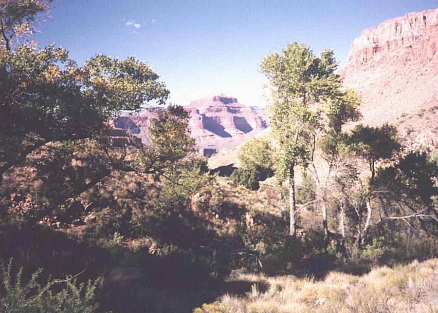
The views from the trail, when we could take our eyes off our feet at all, were breathtaking. At first Horseshoe Mesa and the teardrop-shaped butte in the middle of it looked small and way down there. But as time went on it got bigger and we were looking at it more from the side than down on it from above. As for Wotan’s Throne and Angel’s Gate, the two towering formations across the river, from Grandview Point they were hard to discern against the backdrop of the North Rim. But as we got further down it became apparent just how massive they really were.
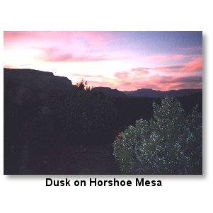
Once we got down to the saddle between Hance and Grapevine canyons, the steepest part of the day’s hike was past. We also were out of the shadow of the northeast-facing cliff and into the sunlight. The trail proceeded in a generally northerly direction toward the mesa, passing along a spectacular vantage point at the upper end of Cottonwood Canyon. Along the way we met several overnight hikers coming back up and several dozen day-hikers returning from their outings. It was getting on toward late afternoon when we passed the old mine. We stopped to drink some water in the shade, and looked inside to see the remains of the vertical shaft inside the cave-like chamber. From there it wasn’t too far to the campground on the mesa, which we arrived at a not long before the sun went behind the rim.
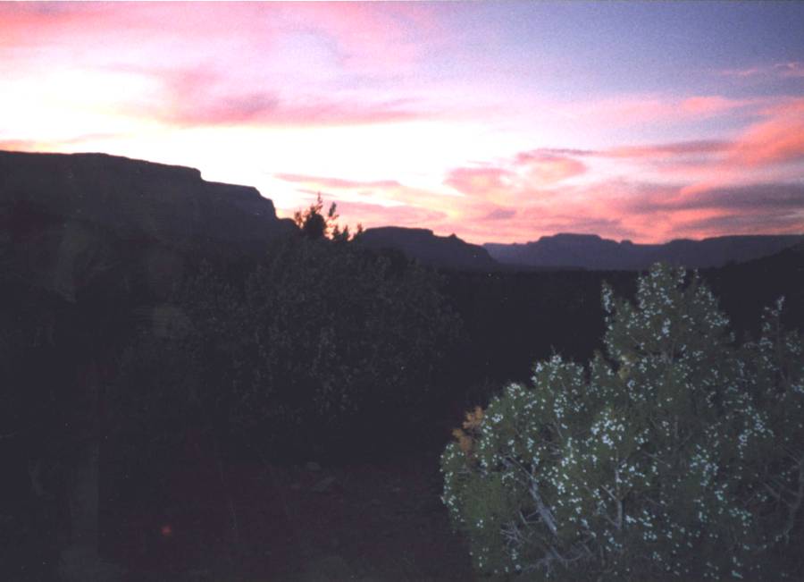
Once we got our packs off we began to realize how much our quads were burning from the descent. There was still plenty of time to make camp and cook dinner in the light of day, but by the time we finished cleaning up it was nearly dark. As we tightened up, moving around the camp became more and more of an effort and it seemed to take ridiculously long times to get the simplest things done. But it wasn’t just the muscles; watching the breathtaking fall of dusk from within the canyon stopped us in our tracks with awe countless times as we finished our chores for the day. That night we slept well.
Dawn in the canyon is just a awesome as dusk. I’m an early riser and was awake before first light, so I saw the light show staged by the emerging sun as the color of the rocks changed from the deep blues, grays and purples of predawn to the earth tones of full sunlight. We were quite stiff from the previous day’s exertions and it took a while to get moving. Eventually Kristin rolled out of the sack, we cooked breakfast, ate it, struck camp and packed up. It was 9:30 a.m. or so before we got on the trail.
We backtracked across the south end of the mesa the way we had come until we found the trail that branches west into Cottonwood Canyon. It immediately became apparent that this path was much less heavily tread than the Grandview Trail, and we were soon traversing some switchbacks leading down into the upper reaches of Cottonwood. The trail then led toward the north, below the western rim of Horseshoe Mesa. Looking back the way we’d come revealed some abandoned prospects from the mining days a century ago. It was on this stretch that we met a party of three guys who were coming out after a several day stay in Cottonwood Canyon. I was beginning to be concerned about water. When I checked up on the latest conditions at the Backcountry Office on Sunday morning the ranger said that water had been reported in Cottonwood Canyon by a party that had returned just a couple of days before. There were no guarantees, however, and we had used more on the previous day than I had planned. We still had at least three liters each at this point but I was concerned that it might be tight if we had to make it all the way to Grapevine Creek before we could replenish. The three men, however, assured us that water was available in Cottonwood. Relief.
The trail finally turned west from beneath the rim of the mesa and began a series of switchbacks down the crumbly slope toward the creek bed. There were places along here where it was hard to distinguish the trail from the surrounding erosion of the desert hillside. Finally, after a dozen or more turns back and forth, we arrived at the dry creek. After walking downstream for a half mile or so we came upon some damp sand in the creek bottom, then a little further a trickle of seepage and finally a small pool of water about two feet square. About ten yards away was a campsite. Kristin and I looked at each other and we both said “This looks like home for the night!” It was about 1:00 p.m.
We should have taken Bob Ribokas’ advice and scouted out the start of the trail to grapevine that afternoon. But our bodies were still recovering from the previous day exertions so we didn’t. Only the next day would we realize how big a mistake this was. Instead, we took our time making camp and eating a late lunch, stopping what we were doing every few minutes to gape at the awesome scenery around us. After lunch we relaxed in the shade when we weren’t doing camping chores such as filtering water and stowing gear. It wasn’t too long before the sun fell behind the ridge and we bestired ourselves to fix a light dinner. Once again we crashed not long after dark and slept well.
On Tuesday it was again 9:30 or later before we were packed up and on the trail; this was another big mistake. We should have been loaded up, on our feet and moving out not much after 7:00. We set out northward, toward the river, looking for the point where the trail we’d taken down from the rim of Horseshoe Mesa connects with the Tonto Trail. We didn’t find it. We must have come to it and not recognized it, because after half an hour or so we realized that we were climbing out of the Cottonwood Creek bed and gradually turning toward the east. That meant we must have been on the Tonto Trail heading in the wrong direction; if we had continued we’d have gone between the Mesa and the river and come out at Hance Canyon. So we turned around, determined to keep our eyes peeled for the fork in the trail. When we still hadn’t found it after reaching the vicinity of our pervious night’s campsite we realized we’d missed it again. According to the topo map the fork was very near one of the points at which the Tonto Trail crossed the creek bed, so we decided to follow that down stream and locate the trail crossing. So we turned around yet again and headed back the way we came, this time on the creek bed. That was no fun at all, what with climbing down dry rapids and dodging the deadfall in full pack. After a fruitless hour or so of this we were really dispirited. Few things get you down like carrying a heavy pack and getting nowhere. Obviously, our route finding skills, at least in this terrain, left something to be desired.
By this time it was going on noon, and we were tired and concerned, so we sat down to caucus. We had made no headway toward Grapevine Canyon. We were finding our progress with the overly heavy packs much slower on the “level ground” than we had anticipated, and thus were becoming deeply concerned about whether we would be able to keep pace with the itinerary the Backcountry Office had laid out for us. We were also becoming concerned about our water capacity. We had about fourteen liters of storage bladders between us, and during two plus hours of marching up and down the Cottonwood Creek bed and its adjacent trails we had gone through at least three liters. We knew we’d be OK for that day, since all reports were that there was plenty of water to be found in Grapevine Canyon. But those same reports said that once we left the Grapevine Creek area no water was to be found until we got to Bright Angel Campground, a full, long day’s hike, a dry night, and at least another half a day later. Would fourteen liters be enough for the two of us, given the hot weather?
We were at the point of no return. The alternatives were either to push ahead on toward Grapevine, even though we were concerned that we might be endangering ourselves, or to retrace our steps and go back out the Grandview Trail. We talked the situation over and decided that we just didn’t want to risk it.
The question then became what to do next. Given that it was already noon there was no way we’d be able to climb out that day. That meant that whatever we did we’d be in violation of the terms of our permit. (At this point I began mentally rehearsing my speech to the ranger in the event we were checked. Hopefully, she’d see our our caution as preferable to having my aging body hauled out of the canyon ten toes up.) We figured that we were more likely to run into a ranger up at Horshoe Mesa campground than where we were, so we decided to camp another night in the Cottonwood area. We also decided that we’d stay in a motel for two nights when we got back to the rim, and then go back down into the canyon via the Bright Angel Trail and camp at the Indian Garden Campground on our last night, as scheduled on our permit. That settled, we saddled up again to look for a campsite. We found one a little further up in the canyon from the one we’d stayed at the previous evening, right near a lightly flowing spring just past where the two stream beds in the upper canyon come together at a fork. There was a nice stand of cottonwood trees so we pitched camp and made a lunch.
I felt relieved and disappointed in myself at the same time. I think Kristin felt pretty much the same way. Relieved that we would not be going into what looked like a risky situation, and disappointed in myself in that I had not led our trek properly. But soon the breathtaking experience of the beauty all around us took our minds off of the disappointment, as we watched the kaleidoscope of changing colors projected by the sun as it fell toward the western horizon. There’s a lot to be said for making sure you’ve got time to just hang out and absorb the beauty of this place.
As we were fixing our evening meal we had a visitor at the campsite. Or to be more accurate I should say we became aware that we had intruded on a permanent resident. Out of the corner of my eye I caught some movement near the base of the big rock on the other side of our tent. I looked over to see a small snake, about 16 inches long with black and white transverse bands. I knew it wasn’t poisonous since it didn’t have the triangular pit-viper shaped head, and wasn’t a coral snake, but I didn’t recognize the species. I reached for my camera but he (or she) saw me do it and scurried away before I could snap a shot. After we were out of the canyon I looked in a reptile field guide at one of the GCNP concessions and learned that it was a California King Snake. We finished eating quickly, cleaned up, stowed our gear and then went to bed before it was fully dark in preparation for the long day on the morrow.
My watch alarm went off at 4:30 in the morning, well before first light. Kristin, being the antithesis of the morning person that she is, was as sporting about it as could be expected. By 6:30 we were all fed, packed and on the trail, retracing our steps of two days before. It was beginning to get light out, but well before sunrise.
What can you say about the walk out of the canyon? It’s one footfall after another, for hours on end, with an occasional break. But not very long breaks, since we had so far to go. And every now and then sucking water in through our hosers and munching on snacks. Trail mix and Cliff bars, mostly. By mid-morning we had reached Horseshoe Mesa and, after passing the old mine again, began that long stretch that heads pretty much straight south, on the west side of the ridge between Hance and Cottonwood creeks. Soon we met the first of the many day hikers we encountered.
We had started out with over six liters of fluids each, and we were also hiking out with at least five plus days’ worth of rations. Thus our pace got slower and slower as the altitude increased and fatigue set in. When we got to within a thousand or so vertical feet of the rim I began running out of breath sooner and sooner after each rest break. By the time we were perhaps 500 feet below the top it was getting close to 4:00 p.m. and I could barely take 25 steps before pausing to recover my wind. Kristin, being almost 35 years younger, was in relatively good shape by comparison. We caucused again and I told Kristin that there was no way we’d make it out by sundown at this rate. Visions of us arriving at the top after dark, with no one there and no way to call a cab, danced in my head. I decided to off-load as much as I could, cache it, and come back down the next day to retrieve it. I removed at least 30 pounds of stuff and Kristin contributed a few pounds as well. It was mostly our oversupply of food but the cache also contained a few clothing items and a couple of bladders of water we were now confident we wouldn’t need. We put it all in my waterproof OR bag and, after leaving my name and permit number on it, we hung it from a tree limb, hopefully out of the reach of the varmints.
That made all the difference. I was still very tired, but at least I could put one foot in front of the other a couple of hundred times before needing a rest. About 4:30 we came to those last, few very steep and stone-paved switchbacks that are the signature of the Grandview Trail. I’m not normally bothered by acrophobia but I was that day on that stretch. Perhaps my fatigued and wobbly legs made me more conscious of the breathtaking drop-offs than I was on the way down. Finally, about 5:15, with only 20 minutes or so until sundown, we crossed over the stone wall onto the overlook at Grandview Point.
The day’s long trek was behind us, but we still had the challenge of getting back to Canyon Village where our car was parked near the Backcountry Office. We couldn’t find a pay phone to call a cab so we began asking the rim-rubbernecks whether anyone had a cell phone that we could borrow to make the call. No one did, but a very kind couple from Florida offered us a lift in their rented subcompact car. Kristin and I collapsed into the back seat and with help from our good Samaritans just barely managed to squeeze our packs in as well, onto our laps. I don’t recall buckling our seat belts but it wouldn’t have made any difference; our packs had us wedged in so tightly that we would have stayed put in the severest of accidents. During the pleasant ride back to the village we learned that our hosts had been at the canyon for several days trying to get an overnight camping permit for one of the below-the-rim camp grounds, so far without success. Kristin and I were wrung out and our occasional contributions to the conversation were monosyllabic. But never has a proffered ride been so appreciated. If you’re reading this, you wonderful folks from Florida, thank you again!
Kristin and I drove to Tusayan, checked in to a hotel, ate dinner and crashed. No problem sleeping that night. After a late, leisurely breakfast at the El Tovar Hotel on the canyon rim, we drove out to Grandview point with a nearly empty pack and hiked down to the wooded point where we had left our stuff the previous day. Fortunately the cache was undisturbed either by humans or varmints, so we loaded up the pack and then humped the stuff back out. Total time in and out, not much more than an hour. Surprising what a good night’s sleep and a couple of delicious meals can do to restore one’s vim and vigor.
On Friday, we awoke to six inches of snow. But, being native Minnesotans, we would have had to forfeit our birthrights if we had let a little October snow in Arizona intimidate us. Anyway, by the time we had breakfast, packed and loaded up the car it was mostly melted. It was about 10:00 a.m. when we got to the trail head.
The sloppy snow on top of the mule due made the upper reaches of the Bright Angel Trail a pungent mess. But we got used to it, and it wasn’t too many hundred vertical feet below the rim before it was apparent that the precipitation had melted into rain before it hit the ground. Still was a mess though. The other thing that took some getting used to on this trail was the traffic. It was a freeway compared with the Grandview, in spite of the weather.
It was about 40 and overcast at the rim when we started out, a far cry from the sunny skies and high sixties we’d encountered at the Grandview Point trailhead five days before. As we went lower into the canyon the temperature rose somewhat, but there was still a definite chill in the air. Clouds scuttled past overhead, occasionally revealing a patch of blue, but not for long.
We arrived at Indian Gardens after about three hours on the trail. We selected a campsite, pitched our tent and looked around a bit. Not far away, near where the trail heads out of Indian Gardens down toward the river, there was one of those big dial thermometers. When we got close enough to see that it read 60 degrees F Kristin and I looked at each other. No way did it feel like 60. I had a small thermometer attached to the same cord on which I kept my compass and that said 60 too. We both felt quite chilled and found it hard to believe that if this were Minnesota in April we’d be out in t-shirts. To warm ourselves up we ceased our explorations, went back to the campsite and brewed up a hot lunch. It really hit the spot.
After cleaning up we packed some water and a few snacks and headed out to Plateau Point. As we made our way out from the shelter of the side canyon onto the plateau, the wind hit us. It must have been blowing at a steady 30 mph, with gusts up to 50. We were very glad to have our Goretex jackets on. After a hike of almost an hour we reached the point and got our first and only glimpses of the river responsible for all the grandeur around us. It’s sobering to look back up at the rim, over 3,000 feet above and then look down to the river, almost another 1,500 feet below.
Out on the point we were really exposed to the wind and we were beginning to feel chilled again. I looked at my mini-thermometer. Still 60 degrees. I decided then and there to throw the thing out when I got back to civilization. There’s no way it could have really been 60.
By the time we got back to our campsite it was late afternoon and we felt colder than we had all day. We were shivering, Goretex and all. The dial thermometer STILL said about 60, maybe a few degrees less. It must have been the biting wind of low humidity air hitting bodies depleted of blood sugar by the week’s exertions. We needed food, so we dove into the packs to see what we had. We fixed a couple of freeze-drive meals but they didn’t help much. Still hungry, we rummaged for something else. About all we had besides trail snacks and cereal fixings for the morrow was a big package of instant mashed potatoes. We brewed them up, adding some evaporated soy milk and olive oil to the mix, and were they good! From now on, I’ll never again go camping without them. When we get together Kristin and I still talk about how good those mashed potatoes tasted, how they warmed us right up from the inside out. We crashed into our sleeping bags as soon as we’d cleaned up after dinner. It was only about 6:30 but we wanted to stay warm. It was a good place to chat about what a great week it had been.
The next morning we arose soon after it got light. This time when I looked at my thermometer it read about 40. It must have been colder than that not long before, however, since there was frost on the ground. Curiously, we didn’t feel chilled to the bone like the previous afternoon. Those potatoes must have stuck to something. Anyway, we had our breakfast, packed up and fell in with the human and equine (mules do qualify as horse-like, don’t they?) tide trudging up the Bright Angel Trail. Along the way we met a middle aged trail runner who looked like he had about 0.5% body fat. An hour and a half or so later he passed us on his way back up. We also met a few of the clueless who charging down in ill-suited gear and attire, it not yet having occurred to them that they have to hike back up. Most touching was a man in his forties hiking up from the river with some one who must have been his father. The older gentleman was at least well into his seventies and he needed to stop quite frequently even with the light pack he was carrying. He seemed to be savoring the view of the canyon at each stop. Perhaps he was saying goodbye to an old friend on what he knew would be his last visit. .
We reached the rim around noon. It was now time for us to say goodbye to our new friend before our leisurely day-and-a-half drive back to Phoenix to catch our Monday morning flight. So before hitting the road we replenished ourselves at one of the restaurants in the village and then walked out to the overlook on the rim. We’ll be back.
|
|