April, 2000
Hermit, Slate, Boucher
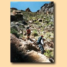
Jerry Forster, John Leonard, Norm Kern
Day Before -Arrived at the old backcountry ranger office only to remember it had moved. Luckily there was a map to the new location. We got the secret code to the west rim road gate in plenty of time. At Babbitt’s we picked up the Propane and Jerry got water.
Day One - To Hermit Creek - Breakfast at Yavapi Cafeteria; Pancakes, Biscuits and Gravy, Oat meal, coffee, coffee, coffee. Used the secret code and drove down the West Rim road. Sneaked a peak from Pima Point at the area we would be hiking. On the Hermit trail by about 9. About 10 cars at the trailhead meant about 10 parties in the use areas we would visit. Jerry counted parties hoping to get to 10. We got to 8. Many parties were coming up Hermit after going down Boucher. Each one mentioned the sliding and looseness of the Boucher in the Travertine area. It seemed Bob Ribokas was right. Going up a loose trail is easier. We also ran into people coming up from Monument. Norm and Jerry realized that they had change in their pockets at the Hermit/Dripping Springs junction. They didn’t want to carry the extra onces for 40 miles so they just left it all on a rock. Norm predicted the quarters would be gone but the pennies would still be there upon their return. Took a long break at Santa Maria, as Norm had to fill a bottle and top off his canteen. The outhouses at Santa Maria are below the trail on the South west side. They are covered with the natural rock and not obvious at all. Great Views. As it had in 1992, the Hermit seemed as debilitating as the Tonto as it worked its way back and around multiple alcoves. We were sure the Cathedral Stairs would be just around the next point one alcove too soon. Shade got rare but we managed to find a little for our “2 seconders”. The Stairs make the Red Wall descent very easy. The Muav section is not too loose. As we got to the Tonto Platform we caught up with two guys who were on their first backpacking hike. We arrived at the campground at 5pm. Took the large site near the big flat rocks (nearest the outhouse. Most of the food in an ammo box, and some hanging in a tree.
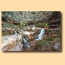
Day 2 - Up and Down Hermit Creek -A pair of guys pointed out a rattlesnake near the outhouse. Norm hoped to walk upstream to see the source of Hermit Creek expecting to see a mini-roaring springs. Based on the few foot prints and total lack of any trails over or around obstacles it looks like very few people go up stream. It can get sort of scratchy in the bushes and brambles, but the numerous and varied waterfalls are worth the walk. We made it upstream about a mile and a half; a bit past the bottom of the Redwall. From that point it looked 100% scratchy and we turned back.
As we approached camp, Norm started to see bits of Granola wrappers on the ground. When we walked onto our campsite, we saw 2 people in completely sealed suits with respirators. Norm thought X-Files and thought we were going to die from inhaling some toxic spill fumes. As it turned out they were just emptying the outhouse. That explained the low flying helicopter we saw earlier. One guy told us of the frenzy the squirrels were in as they raided the Green (John’s) pack. John had two big Rubber Maid tubs inside his pack. They had chewed a huge hole in one cover and almost completely emptied one of the tubs. Many granola bars and John’s favorite bread sticks. Only a single granola bar was left. The fact that the second tub was untouched is probably only due to the park rangers “dropping in” at the critical moment. To get away from the outhouse cleaning and the expected wind of the returning helicopter we moved our camp down the hill. It looked like rain so both tents went up. We talked to one ranger as they waited for the helicopter. He remarked that you have to have your own reasons for working for the park. He had just come off an 87 day river trip. Tough job, but someone has to do it. The helicopter did not have to get very close to the ground to lift the 50 gallon drums, so there was little wind to blow the tents away.
Walked down to Hermit Rapids. Wow. Wish we could have seen boats there. Norm slipped off to bath and then to take a nap. When Jerry and John found only his boots and soap, they thought he had been raptured, and … Norm stayed to watch the rapids for an extra hour. If you watch the rapids long enough and then look up, it seems the whole rock wall is moving to the right. Jerry give John intensive therapy to overcome his squirrel rage.
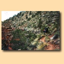
Day 3 - On to Boucher Rapids - Even as we started to leave Hermit camp we saw a squirrel trying to get into a pack in broad daylight within 8 feet of the owner. Brazen Squirrels! Jerry and Norm’s recollection of this stretch of Tonto was tedious, very tedious. It turned out to be pretty routine and not too tedious. It was not at all exposed along the river but was looser in the Tapeats descent to Boucher than we remembered. We got over to the creek just about the time we wanted lunch. We bathed our feet in the creek and ate in the shade. After lunch Norm walked up stream about a mile to the top of the Tapeats to where the water comes out of the left side of the canyon. No water falls, the creek just comes out of the wall in a few different flows and dripping springs. He went around the next bend in the canyon and climbed up under a Muav overhang to enjoy the scene and the silence of the canyon. The frequent overflights took some of the joy out of that moment. There were some deer tracks in the creek but few human tracks. This hike was much more open and uninhibited than the Hermit Creek hike.
John and Jerry proceeded to the beach. They found shade under the tammies just down from the established camp site south of the creek. There were drift wood benches and tables for cooking and eating. We all remarked that it seemed like Boucher creek had so many bends we didn’t know if we would ever get to the beach. No one else was at the beach that evening. Norm and Jerry went directly to the site where they had camped in ‘92 but it just wasn’t there. Norm could find some familiar Schist but the rest was just gone. On the other hand they did not remember any dune on the north side of the creek. Perhaps the “Flood” had pulled all the sand off the beach above the rapid and deposited it all below the rapid? We read, bathed, tried to nap but for the flies, had stroganoff for dinner. Two motor rafts passed, but Boucher rapids provided few thrills to boats that large. Norm and John hung most of the food in the Tammies. Norm had his pack very near his sleeping bag and was awakened by rattling of tin foil. He arose to startle a squirrel that was after the Pringles.
Day 4 - To Slate - We left camp about 7:30. Walking upstream we met a couple of fellows who reported they had spent the night on the Tonto because they missed the junction where the Boucher went down. They had come down the Boucher but instead of going down at the trail junction had gone back up on the Tonto. They had little light and little water so stayed up there and came down this morning to camp at the creek. They were day hiking to the rapids. We pumped full water at the creek and were climbing through the Tapeats by 8:30. On the Tonto we met a shirtless fellow who was coming over from South Bass. He told us of some cairns that marked the route down into Slate, but he warned it was a route not a trail. We had some idea what he was trying to tell us. The walk parallel to the river seemed short but the length of the trail along Slate offset it. There are 3 watersheds with various sub watersheds which must all be walked around. This section gets tedious. We found a nice bit of shade behind a large bolder in one of the watershed crossings. We looked for the spot where we had camped on the Tonto in 1992. We found a couple of possible matches.
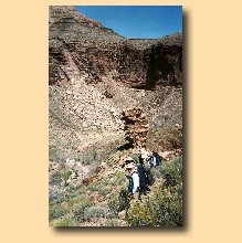
Finally we reached the cairns for the descent into Slate. They are about 80% of the way back towards the head of Slate. We had tried this in 1992 but had found it too loose and had gone back to Boucher. This time we were better prepared and much more experienced. It is loose but is well marked. There is a saddle that extends out into the middle of Slate. It has a huge Tapeats Jenga column at the end. As the route descended to the saddle we were west of it. It looked like people had continued down the west side of the saddle but there were no more markers. We spotted more markers on top of the saddle and then down the east side. This side seemed much steeper but we followed the markers. It was quite steep and hands and knees and butt slides were required. If you aren’t sure about the descent through the Tapeats, turn back. The rest is much worse. About 2/3 of the way down the cairns give out and you have to make up the rest yourself. Working to the right seemed to work just fine. When we reached the creek bottom we found ourselves in excellent shade with plenty of smooth rocks to sit on for lunch. It took 4 hours from Boucher creek. We saw that if we had continued down the West side of the saddle, we would have had to climb down a 12 foot waterfall in the creek bed. John thought we could climb up but was not sure we could have climbed down. The walk to the river was about 30 minutes and was quite direct compared to Boucher or Hermit. The water in Slate seems quite mineral laden based on the white powder all over the streambed. There is lots of green stuff growing in it too. The flow is pretty weak at best. We only saw tracks from one other person.
As Harvey says in his book, there is no beach at Slate. The Slate canyon ends right at Crystal Rapids. Whatever beach there might have been at Slate was probably quickly washed away after Crystal Creek flashed and made the rapid as big as it now is. We took off our packs and scurried across the Schist into the shade of a wall. From this spot we could observe the chaos which is Crystal Rapid. Eventually we saw a Dory Party beach upstream and scout the rapid. It was interesting to try to pick out the boatmen and guess at the trip leader. All the Dories avoided the worst of the rapid but one of the baggage rafts got a bit too far left and the boatwoman was knocked out of the raft. The swamper jumped into the seat and tried to maneuver the boat while pulling the boatwoman back in. She got in very quickly, while they were still in the midst of the rapid. We had guessed most of the boatmen correctly. We slept in the creek bed about 40 yards from the river where it was smooth and quiet.
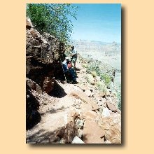
Day 5 - Back to Boucher -At the climbing wall, Norm wanted to get some pictures of Jerry or John climbing up so he took the camera and waited. Jerry hates to wait so he started up the far right side (even though the markers took us more to the center and left). He climbed up the schist that was steep but gives good footing. Norm got his pictures and he and John started up the left side. They got a bit too far left and also were climbing up steep schist. Norm got the same feelings he had when climbing “up the nose” on the Merlin Abyss trip. Pegged his adventure meter. There was a spot where the width of his canteen pushed him too far out to make a move so he had to remove it. The sticks just seemed to be in the way on a steep climb like this. John threw his up a bit, and then could not climb up at that point to continue. He climbed up a different way and when he went over to get the stick he loosened a rock which bumped the stick and knocked it back down the pitch. He had to shop for a new one at Boucher Rapids. When we regrouped on the saddle we each remarked that we don’t think we found “the” way up. On the way back the Tonto seemed even more debilitating. We met another shirtless hiker on his way to Royal Arches. He was hoping for news about water beyond Slate but we were no help. We descended the Tapeats back to Boucher/Topaz in the heat of the day. We sagged into the first shade we could find for lunch. After a rest and refreshment we went back down to the beach. Again, we were alone. John went over to the stick mall below the rapids and brought back 5 sticks for further evaluation.
Day 6 - Beach in the AM and half way out in the PM - As Jerry was packing up his sleeping stuff he noticed a snake crawling under a rock only about 20 feet away. We started to talk about options for next year’s trip. Kanab Creek again? We lounged for a few hours and just as we readied to leave a raft trip went through Boucher Rapids. They had little trouble except for the fellow who was riding on the very bow and was intent on going no hands. He fell but not out of the boat. Even when they ran directly over the biggest hydraulic they did not have a problem. We walked back up to our spot in the shade by the creek. Pumped all the bottles full and had dinner there to avoid the need for water up at Whites Butte. We explored Boucher’s domain, including the mine and his cabin before starting up.
As we reached the Tonto/Boucher intersection some younger hikers asked us if our mom’s knew we were out there. We had been told we were an inspiration but this was a pretty back handed compliment. We chose to take it as a compliment. They were waiting for a couple people to catch up. One had injured an ankle. They knew because they had a pair of walkie-talkies. When they finally caught up, a fellow was carrying 2 full packs. His own and the injured person’s. We were impressed! The whole climb from the creek to the saddle took only two hours. The Redwall climb is quite steep but is nicely sheltered in a big crack so you feel no exposure. On the saddle it was very windy and cold. We passed good campsites and kept going until we were amongst the boulders attempting to get some shelter from the wind. We basically put on everything we had to wear including hats and gloves. We ate what would normally have been lunch and then took a little walk , made some coffee, played trivia and then turned in. John and Norm put up their tents since there was clearly rain (and probably snow) falling in areas we could see. It was also pretty windy. Jerry just rolled up behind a rock and slept with his sleeping back over his head.
Day 7 - The rest of Boucher - It didn’t seem quite so cold in the morning with the sun out again. The scattered clouds made shadows all across the canyon. Beautiful! The clouds and the cooler air were perfect for the climb out. We walked about 30 minutes on the level and then up, up, up through all the Supai levels at once. We were sure Bob Rabokas was right about going up rather than down this trail. It was steep and loose, but going up the footing is much better than going down. We agree with the recommendation of going down Hermit and up Boucher. We had no memories of exposure until we were on top of the Supai. Then there is plenty of walking the edges. The scenery before rounding Yuma point was spectacular with the shadows and then on the east side of Yuma point was just a spectacular but completely different. It seems that the top of the Supai might be the very best level for views? After a few minutes of contemplation of the canyon another overflight would occur and break the mood, so off we’d go again. We rested and snacked right at Yuma point. This would be a nice camping spot if you got a very late start going down or had only a morning to finish going up. The White’s Butte saddle is about half the elevation, so seems like a better camping spot to break up the trip. As you work your way back southwest, the trail even climbs up into the Hermit Shale. This means the trail is one footprint wide, slopes down toward the abyss, is loose, and very near the edge. EXPOSURE. This continues even into the Dripping Springs trail which is a day trip. We saw no one on the Boucher that day. As we passed the Dripping Springs junction, we met a Frenchman who was heading out the Boucher. He asked if there was anything he should know. What do you say? Well, you will wish you were going up while you are sliding down? We told him it is as beautiful a trail as any on the South Rim. We had set the Hermit, Dripping Springs junction as the lunch spot. As we approached Norm remembered the change. All the pennies were still there and all the silver was gone. We had a nice lunch basically eating just about everything we had left to eat. It took us 2 hours and 10 minutes to get to the car. We stopped only briefly to catch our breath in the shade now and then. Talked briefly with a fellow who asked if exposure really meant walking on the edge. We assured him it meant just that. At the trailhead, a friendly Australian fellow took a picture of all three of us. We emptied as much as possible into the trash cans; sorting our week old trash into the metal, glass, aluminum cans. We ended with about a cup of water each and almost no extra food. Perfect.
Showered at the campers building. Noticed the stock market had dipped big time at Babbit’s. Picked up a few more things at Babbit’s and headed for the Sizzler.
|