|
Day 2 - Pasture Wash to Point Huitzil to Royal Arch Creek |
|---|
|
|
|
|
|
Monday, April 15, 2002
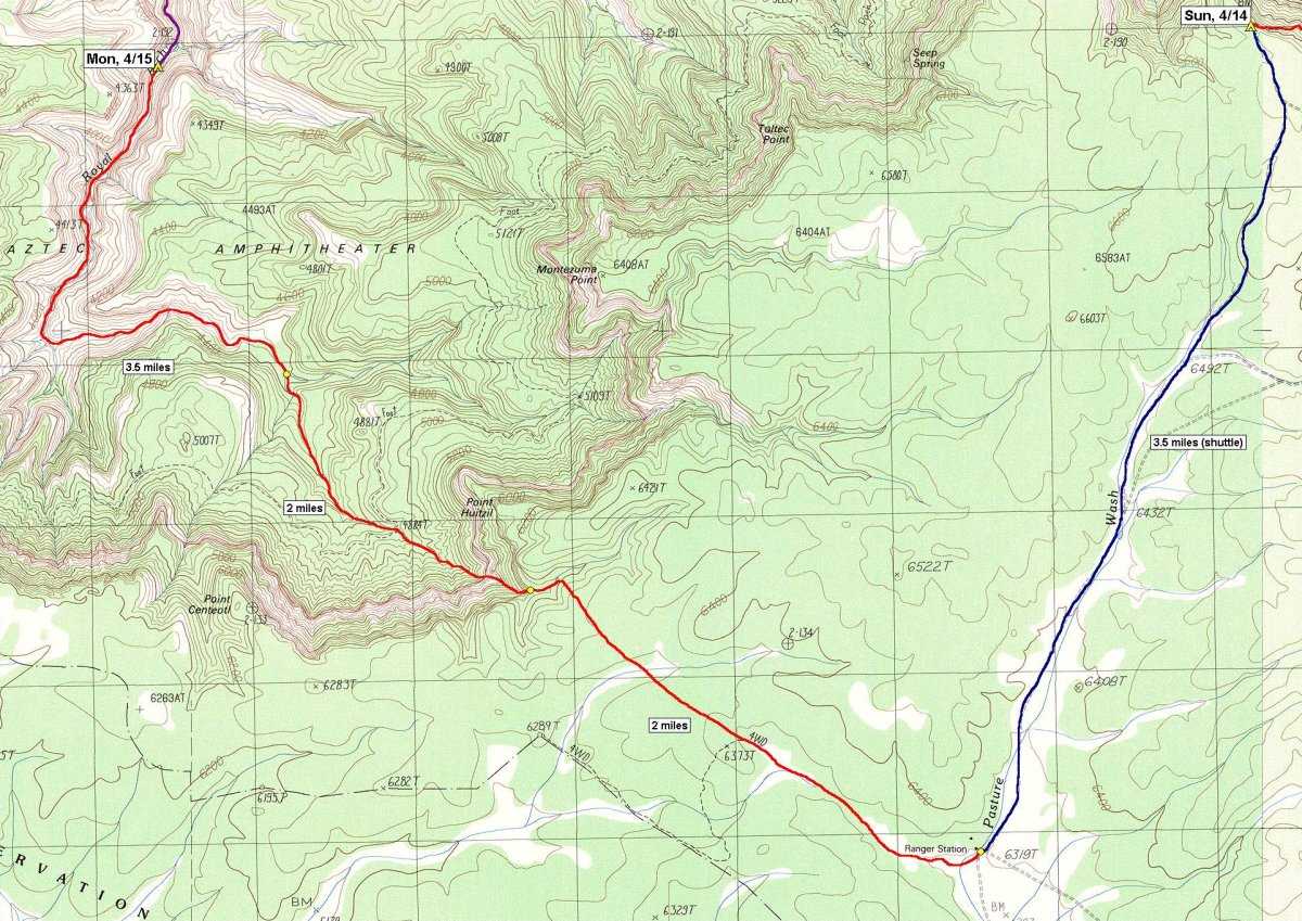
What a day! We all got up a little after 5:30, had breakfast and broke camp. We left Hank's vehicle at the South Bass trailhead, to use for a shuttle pack to Pasture Wash when we hiked out, and headed back to Pasture Wash, with all of our gear, in Mike's. We left the trailhead around 7:00 and got back to Pasture Wash around 7:20. We left Mike's vehicle there, donned our backpacks and started hiking around 7:30. It was very windy for most of that morning until we finally got below the rim. We started hiking along the road that heads west, from just south of the abandoned Pasture Wash structures. After little less than ˝ mile this road turns and heads more towards the northwest, heading almost directly for Point Huitzil. It doesn't stay that way though and after about another ľ mile the road turns again and heads off towards the south. At this point, according to the official NPS route description, you are supposed to leave the road and follow the old telephone line. Well, we saw the point where the road turned south but we never saw any telephone line to follow. We also still appeared to be on some kind of a road even though it doesn't show on the topo map. We took a break around 7:50 and Mike took a GPS reading. After that we left the road and started hiking cross-country in search of the telephone line that we were supposed to be following. It was supposed to parallel the road we were on but was nowhere to be seen. We finally located it around 8:10 and very shortly thereafter started to descend into the drainage on the south side of Point Huitzil. We stopped at 8:25 right where the route goes over the brink and took a short rest. From there is was a scramble down some loose, rocky slopes until we got to the edge of a cliff with no apparent way go continue our downward progress. After some scouting around Mike finally located the tunnel that permitted us to continue further on down. It was now about 9:15. Just north of the tunnel were a number of rock drawings, on some of the cliff faces, and I spent a fair amount of time photographing these while we were resting. These are the best pictographs I have ever seen in the Canyon but even way out here, in the middle of nowhere, the vandals have begun to deface them. Going down the tunnel interesting as it required the passing of packs and we also had to use an ancient Anasazi ladder inside the tunnel to climb down. When I first read the route description and saw the word ladder I got the picture in my mind that most people would: two vertical rails with rungs strung between them. Well, this ladder was nothing at all like that... it was simply a tree that had the stumps of a few branches favorably placed such that it could be used for climbing. It could easily have been a thousand years old. We were down through the tunnel with all of our gear by around 9:40 and we continued down the route. Around 10:00 we reached the top of the Moqui Steps which were really just indentations carved into the side of a steep cliff face, to make it easier to climb. Mike climbed down first and we lowered our packs down to him using a rope. After lowering the packs, we used the rope as a hand-line to more easily descend the cliff face. By 10:30 we were all at the bottom of the cliff. We then had a very slippery descent through the lower Coconino and upper Hermit rock layers and around 10:45 we reached the first of the campsites we were supposed to be monitoring. There were three campsites located on this ridge in the Hermit layer and it really did not look like anyone had been using them at all. The photos I took this time matched the ones taken in 1996 almost exactly. Since we all had our packs off anyway we decided to take our lunch break there as well. We stayed until around 11:55 when a rock fall, caused by the wind, and not very far away, gave us cause for concern and we decided to move on. At around 12:25 we reached the Royal Arch Route and took a short break. The wind was finally gone and it was very nice. We rested again from 12:45 until 1:00 and at 1:30 we reached the infamous ledge. It was pretty creepy looking and I really began to wonder how I was going to do it. Mike went across the ledge and around its obstacles with his pack on and so did Hank, but Hank did not have an easy go of it. This was little comfort to me regardless. Mike offered to carry the other packs across and this sounded like a fine solution to me and I agreed. I made it along the ledge just fine without my pack and did not even give it a second thought. Mike later had second thoughts about carrying the other packs across so we lowered them to the canyon floor below and then went back to retrieve them after descending to the canyon floor. It took us about an hour to get all of this done and we were moving down the drainage again at 2:30. Further down the drainage we encountered some small obstacles where we had to pass packs but we did not encounter water anywhere. There were lots of places where there should have been pools of water, some of them very deep, but it was a very dry year and they were all completely empty. It was nice to not have to wade and swim the pools but we needed water for drinking purposes. Mike knew there were some perennial springs further down the canyon, just above Royal Arch, but he really did not want to go that far today as we knew that there were at least two other groups ahead of us down there and it would be very crowded. We took a couple of short rest breaks along the way. Around 5:00 we finally found some medium-sized pools of standing but reasonably clean water and decided to make camp for the night. I filtered some water and then looked for a spot to camp. I could not find a good place to setup the tent so I decided to go without it for the night and just made camp to one side of the drainage. I just spread out my tarp and put my mattress and sleeping bag in the middle. I was ready for bed around 6:30 and we just stayed up and talked and waited for dark to fall. We hit the sack around 7:30. |
|
|
|
|
|
|
|---|
|
|---|


