| 05:00 |
I was up early and determined to get started on this day as early as possible. After eating a quick breakfast I exited my tent and the sky was just beginning to brighten enough to see by. I broke down the tent, packed up all of my gear and was heading back down into the Tapeats gorge just before 06:00. The night had been simply gorgeous and very cool. I did force myself to climb out of the sleeping bag and tent once during the evening to take a gander at the glorious night sky. This was around 23:00 and it was still plenty dark. I've never seen a night sky anywhere that compares with the Canyon on a moonless night. The waning gibbous moon was approaching last quarter and finally rose around midnight to light up the evening sky. There was also a very bright star just to the east of the moon, which I believe was actually the planet Jupiter. It is amazing how much light even a half illuminated moon will cast.
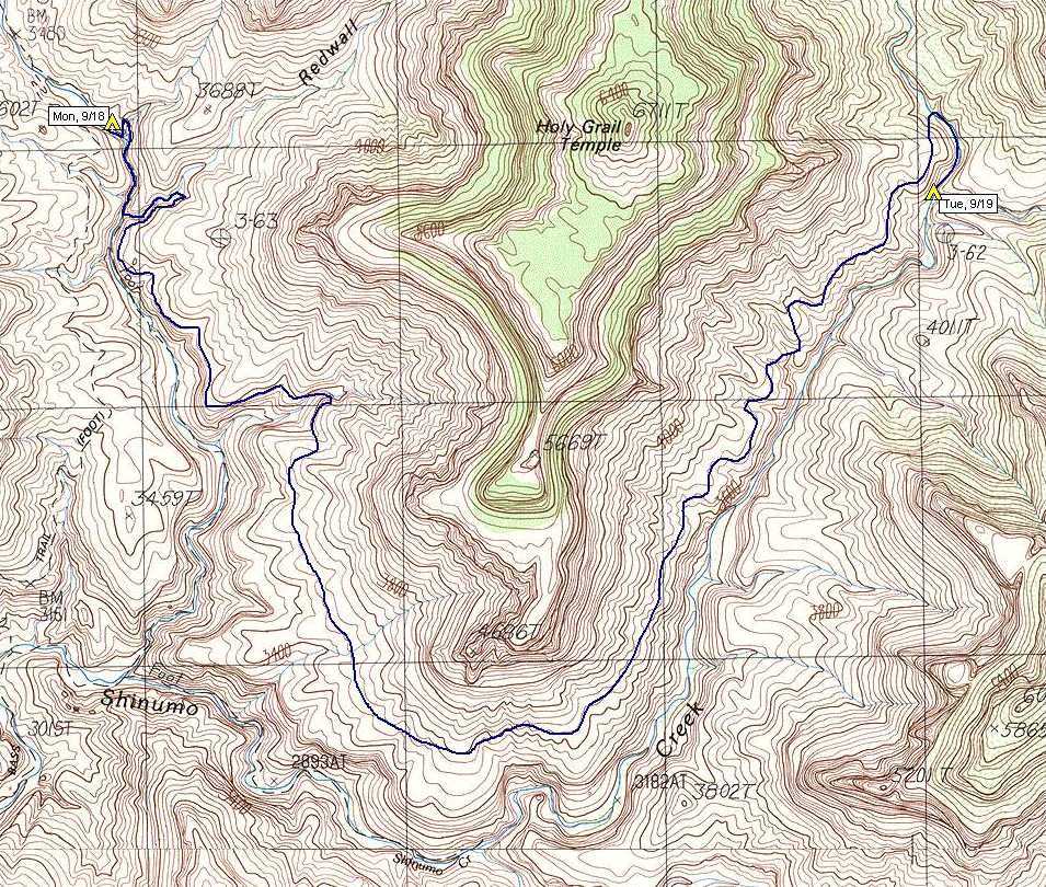
Once back down in the gorge I immediately set to the task of refilling the water bottles, drinking as much as my body would hold and then filling them again. Today was going to be a trip. While heading down the creek to the mouth of Redwall Canyon I noticed numerous bats flying about in the gorge, many more than I ever remember seeing at any one place in the Canyon.
|
| 06:30 |
Reached the mouth of Redwall Canyon and started up. With some difficulty I managed to push my pack up above the ledge next to the first falls. Pushing it up wasn't that difficult but I needed to push it past where the handholds were that I needed to use to climb and it just did not want to stay there. Finally it managed to catch on something. Once up, I grabbed the pack and carried it over along the ledge to a place above the falls where I could safely put it back on.
Getting past the next two falls was a breeze and at no time I was at the base of the first real climb. "Do I try it with the pack or haul the pack up afterwards?" Laziness overcame me. I didn't want to take the pack off, get out the rope... yada, yada, yada. So climb with the pack it would be and climb with the pack it was. No problem at all. The next falls was not even a question and in no time at all I was above all of them and staring at the Tapeats rim. I took off the pack and rested a bit, logged an entry in the notebook and looked around again for the easiest way out. The little brush-clogged ravine to the south still seemed the best bet so that's the way I went.
|
| 07:10 |
Back up on the Tonto platform and celebrated by eating my morning package of Peanut M&Ms. Finding the route was easy as this must be the most popular way for accessing it. As soon as I started heading along the rim and back towards White Creek I realized I was already on it. Following it south to the next major drainage was a breeze and I figure I was on it for maybe 95% of the time, loosing it occasionally and then re-finding it again.
|
| 08:00 |
Reached the point where I had lost the trail during my prior attempt. I kept an eye out on the way into the drainage and did not see any place where the route could possibly go anyplace else. I found the cairn that indicated to me that I should cross the drainage and then nothing, nil, nada... just like last year. This year I had the advantage of being here about 4 hours earlier, still in complete shade, having plenty of water, no smashed knee and a digital camera with no fear of water. Life was good. I took off the pack on the other side of the drainage, where the route out should be, and starting hunting around. There were no cairns and no sign of any route whatsoever. I climbed up the debris slope in the center of the drainage and took a look around from up there. I could see the well-worn route coming into the drainage on the north side but there did not appear to be anything on the south side. There was a ledge there that looked like a likely possibility but it showed no sign of travel by anyone.
|
| 08:35 |
I finally decided to just try the ledge and see what would happen. I had plenty of time and I knew where the route had to go, eventually. I did end up having to climb a little as the ledge eventually gave out at a smaller drainage and did not continue on the other side. I figured that being above the actual route would be better than being below it anyway as at least I would stand a chance of spotting it from above.
|
| 08:55 |
Spotted a cairn at about the same level I was at but a little further south and west. I worked my way over to it convinced that I would be make on the real route but there was nothing anywhere near it that even remotely resembled a traveled path. I continued heading south and west at the same level.
|
| 09:15 |
Finally connected with the real route again. No sign of where it came from... it was just there again, all of a sudden, just above the rim rock at the edge of the Tapeats gorge.
|
| 09:20 |
I am finally in the sun but I am very happy because I am back on a real route. I stopped in the first shady spot I found to rest, drink and update the logbook. I had an awesome view of the White Creek/Shinumo Creek confluence far below to the southwest. Someone told me last year that the views along the burro route were spectacular and now I am beginning to realize what they meant.
|
| 09:35 |
Head out again, eager to get as much of the route as possible behind me before it gets too hot.
|
| 10:00 |
I just passed below the 4686T point at the south end of Holy Grail Temple. This is a good feeling as now I figure I am just about at the halfway point in the hike. From this point I have an awesome view of Dox Castle just the other side of Shinumo Creek. After a short rest I continued on.
|
| 11:00 |
Starting to get hot and I was starting to get hungry so I started looking for some shade to hide out in for a little while. There is a serious shortage of shade along this section of the route as there aren't really any side drainages with ledges, which would normally provide it. There are, however, a few very large boulders and I just needed to find one that was the proper height and facing the proper direction so as to cast a shadow large enough to hide in. I checked out a few that looked promising before I found one that would work long enough for lunch and a good rest. It felt great to get the T-shirt, boots and socks off and to let things dry out. It was actually very cool in the shade and at times I almost felt like I was starting to shiver. I had started to notice the sole of my right foot feeling a bit funny but after taking the socks off I couldn't see anything. Before putting socks and boots back on I applied some moleskin just to be on the safe side.
|
| 12:10 |
I know I should have rested longer and stayed out of the mid-day heat but I was very eager to get to camp for the night and so I headed out again just after noon. The views of King Arthur Castle on the other side of Shinumo Creek and of Elaine Castle down near the Merlin Abyss / Mordred Abyss confluence were spectacular along this section of the route.
|
| 12:45 |
As I was entering a rather sizeable side drainage I noticed a small group of three Grand Canyon bighorn sheep on the other side. I tried to get close enough to get a good picture but they wanted no part of it. I did manage to find a nice spot of shade in the back end of the drainage and rested until 13:00.
|
| 13:40 |
The next section of the route had numerous side drainages and I lost the route on several occasions. It seemed like the route was fading away and was getting increasingly difficult to follow. I needed to start paying much closer attention to where it was going in order to prevent myself from loosing it. I knew that I was getting very close to my destination for the day and listening to cool and shady Shinumo Creek below was starting to get on my nerves. I really wanted to get out of the heat and the sun, get down there and soak myself in its waters. I spotted one section where it looked like it might be possible to get down to the creek but it was definitely not the route that I had marked on my map so I continued on.
|
| 14:50 |
I passed a small ruin on the edge of Tapeats rim and concluded that it was the Anasazi ruin that people had told me about. I knew that the descent to the creek must be very close but shortly after that the route faded away into nothingness again. I managed to work my way down the slope to the edge of the creek but was still on top of a short cliff with maybe an eight-foot drop. I couldn't see a safe way to get down with the pack on so I bit the bullet and got out the rope to lower it down. Without the pack it was an easy climb down to the bottom of Merlin Abyss.
|
| 15:05 |
All I had left to do for the day was to work my way down to the Merlin Abyss / Mordred Abyss confluence and find a place to camp. There was supposed to be a good site right at the confluence. After about a 10-minute walk, crossing from side to side along the creek, I was at the confluence and found the site. It was a beautiful location, nice and cool and shady, and it would be very nice to be camping next to water after the dry camps of the two prior evenings.
|
| 15:30 |
After setting up camp I headed down into the creek to try and wash off three days worth of sweat and grime. I even got out my wonder bucket and managed to wash my hair... far away from the creek, of course. Boy, did that feel good, there's nothing like trying to wash your hair with ice water. I felt very good afterwards though and knew that feeling clean again would make for a very pleasant night's sleep. Of course that feeling would probably be destroyed after being on the trail for an hour or so tomorrow morning but still it felt wonderful at the moment.
On the way back up to camp from the creek I noticed a rattlesnake coiled up in the rocks just below and under the bank. Great! I had just came down that way, had probably put my leg within easy reach of him and had nothing on except my shorts. He was not visible from above and that made me very nervous. Luckily he appeared to have no interest in me at all and must be a very sound sleeper. I will definitely need to be careful if I need to get up at night. I thought about trying to move him but figured that would be a lot more dangerous than just leaving him alone. I checked on him every time I went down to the creek and for the whole time I was camped there he never moved an inch.
The Merlin / Mordred confluence was not at all what I expected. It seemed a lot more flat and open on the topo map and I really did not expect the high Tapeats cliffs that I was now looking at. It was still a very pretty area but it just wasn't what I expected. Well, it is the Grand Canyon after all. I was also very proud of myself at finally being able to complete the burro route. The climbs up the dry falls in Redwall Canyon had me a bit worried at the start of the trip. I was glad that I decided to give up when I did during the prior trip as I knew that I would not have made it over here before dark and would have ended up in a dry camp with very little water.
Because of the proximity to water there were a lot more flies at this campsite than there had been at the others and they were a bit annoying at times. I was going to eat inside the tent but then I found this incredibly nice block of Kaibab limestone that was just loaded with fossils. It protruded out into the creek a bit and the flies were not bothering me while I was out there so I decided to use it for my dinner table. It really was the finest example of Kaibab limestone fossils that I had ever seen and I wondered about the route that this massive piece of rock had taken to get from the top of the Canyon all the way down to the bed of Shinumo Creek. The amount of time that this must have taken seemed like an eternity in itself but I knew that it was just a flash in the pan compared to the age of the rock itself and the fossils contained within it. I was in complete awe at having such a wonderful dinner table. The hot dogs that I had for dinner still seemed to be holding up OK and I hoped they would remain so for the rest of the trip.
|