|
This would prove to be an "interesting" day, to say the least.
We were up early, at 5 am, for the 5:30 breakfast and the Phantom Ranch breakfast was delicious and filling as usual. After breakfast it was still to dark to do anything so we just went back to our cabin to lay down for a while and wait for the morning to brighten enough to hit the trail. I had no intention of starting up an unknown route in the dark. The sun was coming up very late these days, around 7:45 or so, but by 7:30 it was light enough so we donned our packs and started off down the trail to Bright Angel Campground and the beginning of the Utah Flats Route.
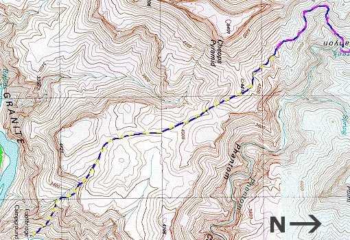
The official NPS trail description says that the trail starts at campsite number 33 but it actual starts just north of campsite number 1. I can only assume that the sites were renumbered from the other end at some point but no one has bothered to update the trail description. We found the start of the trail easily enough but that was the end of the easy part for a while. Once you are on the trail it climbs sharply away from the campground up a steep, talus slope. Rocks were constantly shifting beneath our feet and I was not looking forward to coming back down this way. After about 20 minutes of climbing we came to the 15-foot cliff that is mentioned in the official trail description. I knew that there was a way around this to the right so that's the way we went. Robin had a bit of a problem in the exposed detour and then in going up the slope beyond that so I told her to take her pack off and go up without it. After we got to a more level section I removed my pack and then went back for hers. After another half-hour or so of climbing we were finally through the rough stuff and on the nice level section that is just below the climb to Piano Alley. We both took off our packs and rested for a while. We had started up at just before 8:00 and it was now 9:10. One thing great about the digital camera is that it stamps all of the images with the date and time so as long as I was taking pictures I knew exactly where we were and when, and didn't have to take notes. Taking notes about the Utah Flat Route was not necessary, I knew I would never forget it.
After a brief rest we were off again and started up the next slope towards Piano Alley. This section was not nearly as bad as it sounded and it was actually a bit of fun climbing over and around the huge sandstone blocks. It reminded me a lot of the upper section of Mount Washington in the White Mountains of New Hampshire except up there the blocks are a little smaller and made of granite. We made it up to and through Piano Alley in less than an hour and by 11 am we were finally out on Utah Flats proper. We took another short rest there and mixed up some Gookinade. The day was already warming up and I decided that I could loose my sweatshirt and hike only in the T-shirt again.
The hike across Utah Flats was uneventful except for loosing and then finding the trail again periodically. The trail up on Utah Flats crosses a huge field of Prickly Pear and Hedgehog cactus and trying to avoid all of the plants and still head in the right general direction was a little challenging. I never found the next landmark that I was looking for, the sandstone blister, and we ended up becoming dead-ended on the brink of Phantom Canyon. It was a very nice view but not where we wanted to be. After a quick look at the topo map I figured out where we were and where I thought we should be and we headed off again. It was now about 12:45 and I was starting to get hungry. We found the "trail" again about 10 minutes later, on the other side of a sizable hill. On the way back a couple of days later I "think" I found the sandstone blister but I would call it more something more like an outcropping of sandstone. After about 5 more minutes of hiking we came to a nice place to stop for lunch.
After lunch I though I noticed water flowing up in one of the side canyons that feeds into Phantom Canyon and confirmed this with my binoculars. The spot is marked simply as "Spring" on the topo map and is just to the west of Sturdevant Point of Buddha Temple. Through the binoculars it looked like a lovely spot with a long thin waterfall with a plunge pool beneath and surrounded by lots of green. I wonder if it's possible to get up there.
At 1:20 PM we were on the trail again and it was much easier to follow through this section. It went through a couple of small side drainages and seemed to go on and on and on and I ended up wondering if it really did go down to Phantom Creek. Robin was already thinking about starting back to the campground at some point during what was supposed to be our lay-over day in Phantom Creek and she had picked out a couple of possible campsites along the way. She was worried about getting to the descent to Bright Angel Campground and being tired. Anyway... the NPS route description claims that the trail drops into the creek before reaching Isis Temple but we did not find this to be the case. As a matter of fact the southeast arm of Isis Temple was directly above us when the trail finally started down.
It was about 2 PM when we started down and the trail quickly went from good to horrible. It was like a repeat of the climb up on the other end with lots of loose rock sliding around beneath our feet. I knew that it would be a lot easier to come up this stuff but Robin's idea of starting back a day early was starting to sound like a good one. Luckily the trail is not nasty all the way to the bottom of Phantom Creek and the really bad part is actually relatively short and comprises maybe one-third of the descent. The lower two-thirds was a lot easier and was more like just a steep trail than a rocky scramble. I managed to pick out our campsite on the way down and by 3 PM we were there and started to setup camp.
There was not another soul around and it seemed that we had the whole of Phantom Canyon to ourselves. We had been following one set of very fresh footprints along most of the route but they continued up into the northern section of Phantom Canyon and we never saw the person responsible for them. After setting up camp we wandered up the creek a little ways and it was very pretty. Lots of polished sandstone with little waterfalls and cascades along the way. After about an hour we returned to camp and made dinner. We (Robin) hauled a one pound can of spaghetti sauce for dinner that night and we mixed it up with some elbow macaroni. She was sure glad to be rid of that can. By the time we finished dinner and cleaned up it was already getting dark and we headed into the tent and a long winter night.
|