|
Colorado River Smooth Water Raft Trip |
|---|
|
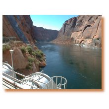
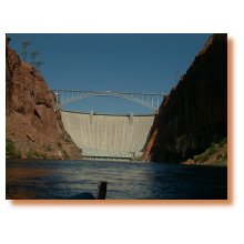
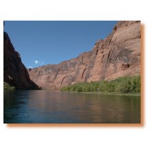
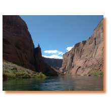
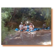
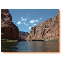
Another one of those things that I've always wanted to do while visiting the Grand Canyon is to take the Colorado River Smooth Water Raft Trip. Since it takes an entire day to do this and I would normally rather spend that day hiking in the Canyon, I just never managed to find the time... until now. In September 1999, my wife, Robin, and I were visiting the Canyon with some family members that are not hikers and so we ended up doing lots of the touristy stuff like this. It was an awesome trip and I am glad that I finally got around to doing it. The trip starts with an early morning pickup at one of the lodges in Grand Canyon Village. We were staying at Maswik Lodge and were picked up shortly after 7 am. There were about 20 people in all taking the tour that day. The bus ride up to Glen Canyon Dam, where the actual raft trip begins, takes about 2 1/2 hours. The bus heads out of the park along the Desert View Drive and makes a short rest stop at the Cameron Trading Post before continuing up route US-89 to Page, Arizona and Glen Canyon Dam. The bus drivers offers a pretty much continuous commentary along the way, except for one interval in which he played a video documentary on the Grand Canyon for us. On arrival at Glen Canyon Dam the bus goes down a very impressive tunnel that is about 2 miles long to reach the base of the dam. The rafts were there waiting for us and after a short safety lecture we were off. There were about 20 people in all taking the tour that day and we had two rafts to accommodate them all. The rafts were huge, measuring about 10 feet wide and maybe 20 feet long. I would have preferred an oar-powered trip but these rafts had outboard motors. I'm not sure the trip could be done in one day under oar power. This trip is called a "smooth water" raft trip because there is no white-water, no rapids, along the entire stretch of the river between Glen Canyon Dam and Lee's Ferry. Our guide did manage to find the one riffle (slightly rough water but not enough to be considered a rapid) and took a vote to see who wanted to go through it. We all did and so he put the raft into it. We got a little splash but it was really a very small riffle. After that, and little further down-river, he pulled the raft in next to a little spring that tumbles down one of the cliff faces, directly in the Colorado. He asked if anyone wanted to take a shower and numerous people did. At first I thought we would have to get out of the raft to do this but he pulled the front of the raft right in under the spring and all we had to do was stand on the bow of the raft to get under the spring.
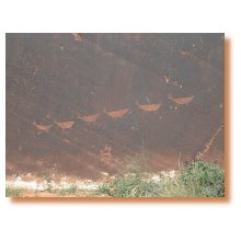
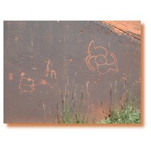
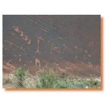
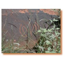
We cruised on down the river for about 45 minutes before making our first stop, a short day hike up to see some petroglyphs. The hike was only about 1/4 mile each way and involved a little climbing but nothing challenging. Back on the river we cruised down among the cliffs for about another 1/2 hour or so before making another stop at some more petroglyphs. The cliffs along this section of the river were very impressive and soared anywhere from 800 - 1200 feet above us. The petroglyphs at this second stop were much more impressive than those at the first but it seemed like the first set was more remote and that not as many people visited them. This stop was much more developed and there was a very well maintained trail leading from the beach to the petroglyphs. There were also several porta-potties located on the beach here so it was obviously a real rest stop. The guide told us an interesting little story about how much the government (you and I) paid to get those porta-potties down there and to keep them in good operating condition. Believe me, you don't want to know. The walk from the beach to the petroglyphs is slightly longer here, maybe 1/3 mile each way, but the trail is much better and virtually flat all of the way.
Back on the river we cruised for another 1/2 hour or so before stopping for lunch. The cliffs were the highest along this section of the river and were very impressive. We also passed a number of fishermen who were trying to haul in some of the numerous trout that inhabit the river. The Colorado River is known for being one of the finest trout fisheries in the world. At one point our guide pulled the raft over to a shallow spot in the river so we could see some of the fish - they were literally everywhere and it seemed like you could just reach in and scoop them out.
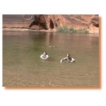
When we got to our lunch stop the food was already set out and waiting for us. There were all kinds of sandwich meats and breads and other condiments available as well as salads and drinks and various types of cookies for dessert. Tarps had been set out beneath the willows and tamarisks along the riverbank for us to sit on while we were eating. After lunch the raft guides offered us an opportunity to go swimming in the Colorado. I was the first one in - well the first adult anyway. Many people were hesitant because the water was so cold (46 degrees Fahrenheit) but eventually almost everyone went in.
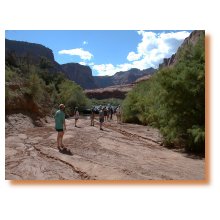
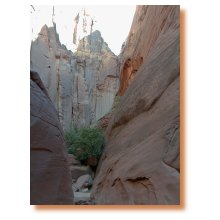
After lunch we cruised down the river again for about 45 minutes before doing our last day hike up one of the side canyons. This one was optional and the guide took a vote to see if people wanted to do it or not. If we did not he said that we could just float on the river for a while, relax and kill time. Luckily (for me), we had some people with us who liked to hike and the majority voted for the day hike. The people who did not want to do the day hike ended up just lounging on the rafts at the river while the rest of us hiked up the side canyon. It was a very nice day hike up a very picturesque side canyon, with tall cliffs that seemed to soar up to the sky. There were no petroglyphs or anything like that up here, just the canyon and the cliffs. This hike was longer than the others, easily 1/2 to 3/4 mile each way. The first half of the hike is pretty easy but you do finally get to a point where you have to climb a little to get around some dry falls and pour-offs. After the climbing section the canyon gets much narrower and the cliffs close in around you. Eventually you come to a dead end with a dry fall that is easily 100 feet high and no way around it. About half of the people who started the hike made it to the end. The rest turned back when the canyon started to climb up.
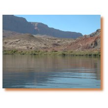
Back on the river we cruised for another hour or so before reaching the end of the trip at Lee's Ferry. The Canyon changes a lot in this stretch. The cliffs get lower and in some places go away completely. We passed through a geologic fault line that runs right across the river, about mile or so above Lee's Ferry. The cliffs on the east side of the river here were eroded far back away from the river into rolling hills and gentle slopes.
It was sad to have the trip finally end at Lee's Ferry and I sorely wanted to hi-jack the raft and continue on down the river. Being on the river again and arriving at Lee's Ferry brought back some very fond memories of the two-week trip that my wife and I did back in 1997 and now I am thinking about doing another one of those trips.
| ||||||||||||||||||||||||||||||||||
|
|
|---|
|
|---|