|
Trip report : Thursday, December 29, 1994 |
|---|
Thursday, December 29, 1994
Greetings Webmates,
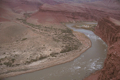
Today I took off along the river in the opposite direction of yesterday, that being downstream. This was a much easier day, only about 7 or 8 miles of total hiking distance. I went west along the Escalante Route as far as the Unkar Creek overlook. This hike was mostly along the river, across dunes, through tammies and around boulders until the end where the trail climbs up onto a bluff from where you can view the delta of Unkar Creek.
The picture above is of the delta. It was once farmed by the ancient Anasazi indians, the forebears of today's modern Hopi peoples. The outlines of some of the foundations from the settlement can still be seen from the overlook and it is still possible to make out irrigation channels used by the residents to divert water from the Colorado River to their fields. This settlement is still being studied by scientists and is closed to visitation. Luckily it's on the other side of the river and not easily reached.
I also did a couple of little side excursions up into some nameless drainages and side canyons on my way back to my campsite. Tomorrow I have to leave this place and start my hike out.
More tomorrow,
Grand Canyon Bob
|
|
|---|
|
|---|