Trip Report, September, 1998
South Canyon
By Bob Anderson
bobsmail@gte.net
South Canyon
Most of my Grand Canyon trips have been planned months in advance. This trip was a little different. For three days beginning September 18th, I hiked the New Hance-Tonto-Grandview loop. I did not have to be home right away, and I felt pretty good, so I decided to hike South Canyon, a trip I've wanted to do for some time.
South Canyon is located in the upper area of Grand Canyon National Park in the portion of the park known as Marble Canyon. The confluence of South Canyon and the Colorado River is located 31 miles south of Lee's Ferry, the starting point of the Grand Canyon.
A hike down South Canyon does not offer the awe-inspiring and panoramic views found in other areas of the Grand Canyon. However, the trip down South Canyon is worthwhile for other reasons. Hikers who make this trip are following in the footsteps of the Anasazi and early European-American explorers who used South Canyon to enter and exit the inner canyon. Near the end of this trip, hikers are treated to an elevated view of the Colorado River and of the precipitous and colorful walls of Marble Canyon. And, after arriving at the Colorado River, hikers can visit Vasey's Paradise and Stanton's Cave, both of which are located within a mile of the confluence of South Canyon and the Colorado River.
In preparing for this trip, I primarily relied on Ron Adkinson's book, "Hiking Grand Canyon National Park." I have planned a number of trips using Ron's book and have always found it to be a very helpful resource. The mileages shown in this report came from Ron's book.
When I obtained the backcountry permit for this trip, the Backcountry Reservations Office (BRO) provided a one page informational sheet on hiking South Canyon. This sheet contains much helpful information, including driving directions to the trailhead and a brief description of the hike.
In preparing for this trip, I also reviewed the Trails Illustrated topographic map. However, this map is of somewhat limited use, because the hike down South Canyon follows a "route," which is not shown on the map.
Getting There
After completing my New Hance trip, I stayed in Grand Canyon Village at the Bright Angel Lodge. The trip to the upper Canyon was a relatively short one of about three hours. So, I slept late, enjoyed a good breakfast at the Bright Angel Lodge, and stopped at a number of viewpoints on my way.
To get to the South Canyon trailhead, you have to drive 21 miles over unpaved forest roads. I was driving a passenger car, and it had rained the previous week, so I was somewhat concerned about road conditions. At the BRO I spoke with a ranger who said that she had driven to the South Canyon trailhead the previous week but did not have any more current information. I also spoke with two rangers at the Lee's Ferry ranger station. Neither of them had driven the forest road to the South Canyon trailhead within the previous two weeks. However, one ranger informed me that another hiker driving a van had not been able to reach the trailhead only two days previously.
Uncertain what to do, I headed west on US Route 89A toward the Jacob Lake Motel. The people at this motel are usually well informed about the condition of forest roads in the area. As I passed the forest road that leads to the South Canyon trailhead, I noticed a pickup truck headed my way. I flagged down the driver, who said she and her family live at the old buffalo ranch about one mile from the South Canyon trailhead. She reported that the forest road had been graded the previous day, and that I should be able to reach the trailhead without difficulty. Having received this good news, I headed for the motel.
The Hike
I woke about 5:00 a.m., so that I could get an early start. I found the forest road that leads to the South Canyon trailhead to be in generally good condition, although the last mile or so was rough and rocky. This drive took about one hour and 30 minutes.
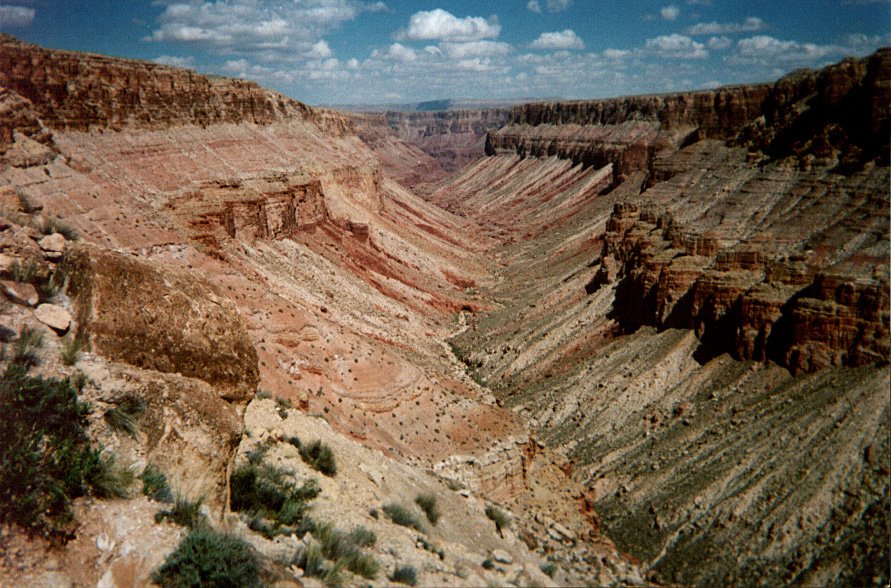
The hike from the trailhead down South Canyon to the Colorado River covers a total distance of 6.5 miles. Over this distance, you descend 2,700 vertical feet. During about one-third of this hike, you follow what most people would consider to be a trail. During the rest of the hike, there is no trail, although sporadic cairns indicate a direction of travel. Route finding is never a serious problem at any point during this hike.
To begin this hike, you pass a park service sign and climb under a barbed wire fence. After a few additional feet, you arrive at the rim of South Canyon. From this point, you have a view of South Canyon that extends most of the way to Marble Canyon.
From the rim to the floor of South Canyon, you follow a well defined trail. This trail covers a distance of about one mile and involves a vertical descent of 1,100 feet. The trailbed is hardpacked and is covered with a moderate dusting of loose dirt. It is also one of the steepest trails I've hiked in the Grand Canyon. As a result, care needs to be taken in descending this trail.
About one-third of the way to the Canyon floor, you reach a series of steeply descending slickrock ledges. Downclimbing these ledges with a pack on would be very difficult. Instead, I lowered my pack using a length of nylon cord.
After reaching the floor of South Canyon, the trail ends. From this point on, you simply head downcanyon toward the Colorado River. The floor of South Canyon is covered with baseball- to car-sized rocks and boulders. So, most of the time it is not possible to travel in a straight line. Instead, you find yourself following a zig-zag pattern, attempting to locate the path of least resistance. On several occasions, I found my progress blocked by large boulders, requiring that I backtrack and find a different route.
There are two tributary canyons that feed into South Canyon. The larger of these is Bedford Canyon, which is located 4.3 miles from the trailhead. The other is located a little further downcanyon and is unnamed.
Between the rim descent trail and Bedford Canyon, there are two pouroffs that block your progress. A third, larger pouroff is located just past the intersection of South Canyon and Bedford Canyon. Trails that ascend the wall of South Canyon bypass these pouroffs. The trail that bypasses the third, larger pouroff descends to the Canyon floor at the intersection of South Canyon and the unnamed side canyon. All of the bypass trails are cairned and are easily hiked.
A little over one mile past Bedford Canyon, and about one mile from the Colorado River, you begin entering the Redwall Limestone formation, which in South Canyon has retained much of its natural gray color. At this point, your progress is blocked by several limestone pouroffs. A cairned bypass trail ascends the left wall of the Canyon and continues the remaining distance to the Colorado River. For the most part, this trail is easily hiked. In some areas, though, Supai slides have covered the trail with large boulders, requiring hand-and-foot scrambles. Also, descents into and out of several small draws slow your progress. About 20 minutes into this hike, the cairned trail narrows as it wraps around a limestone promontory. At its narrowest point, the trail is about 10 inches wide, with the Canyon wall on its left and a steep drop-off on the right. To get past this point, I faced the Canyon wall, grasping whatever handholds I could find, and proceeded forward with a sidestep motion. On my return trip, I noticed what appears to be an uncairned route that allows you to hike over, rather than around, the limestone promontory. If I hike this trip again, I'll try this alternative route.
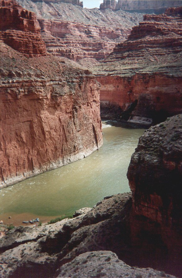
The trail that bypasses the limestone pouroffs follows a contour along the top of the Redwall, while the floor of South Canyon descends to meet the Colorado River. By the time your reach the Colorado River, you are elevated a substantial distance above the floor of South Canyon, yielding excellent views of the Colorado River and Marble Canyon. At this point the trail turns left, heads upriver for about 1,000 feet, and then descends a small, boulder clogged ravine. You then reach what the Park Service identifies as a 12 foot "drop-off." It appeared to me to be closer to 20 feet, although the Park Service's use of the word "drop-off" is dismayingly accurate. When I first reached this point, I assumed there had to be an easier route. Unfortunately, there wasn't. So, I lowered my pack and then downclimbed the drop-off. This turned out to be easier than it first appeared. After a short hike of about 10 minutes, you reach a beach just to the north of the confluence of South Canyon and the Colorado river.
After arriving at the Colorado River, there are a number of sights to see. The most notable are Vasey's Paradise and Stanton's Cave. Vasey's Paradise is located one mile downriver from South Canyon. It is an oasis created by a spring that exits twin caves in the Redwall. Vasey's Paradise is similar in many respects to Thunder Spring, differing in that Vasey's Paradise is much smaller and feeds directly into the Colorado River rather than Tapeats Creek. Stanton's Cave is located between Vasey's Paradise and South Canyon. It was named for Robert Stanton, a surveyor who explored the Grand Canyon in 1889 to determine the feasibility of constructing a railroad line through the Grand Canyon. Stanton found the trip down the Colorado River to be too difficult, so he stored his supplies and equipment in what is now called Stanton's Cave and exited the Grand Canyon by way of South Canyon. In addition, there are numerous caves in the Redwall that are easily reached with only a short hike. These caves are not of any special significance but appear to provide excellent views of the Colorado River and Marble Canyon.
After setting up camp, I headed downcanyon towards Vasey's Paradise. A private rafting party was camped on the beach about half-way to Vasey's Paradise. We talked for awhile about their rafting adventures and my hiking trip. At this point I was pretty tired, and it did not appear possible to hike all the way to Vasey's Paradise, so I returned to my campsite.
Around 5 o'clock I noticed that my once spacious campsite was being reclaimed by the Colorado River. About this time a few members of the private rafting party came up the beach to explore the caves above my campsite. They said that the level of the Colorado River rises daily as water is released from Glen Canyon Dam. They assured me that the water level had pretty much reached its highest point.
The following day I rose early. The return trip went well. The previous day when hiking down South Canyon, I had to lower my pack at two locations. I used nylon cord to raise my pack at these same locations. Toward the end of this hike, a cairn that sits atop a large boulder marks the beginning of the trail that ascends from the floor to the rim of South Canyon. I missed this cairn and continued up South Canyon about one-eighth mile. Before long I recognized my mistake and backtracked. Although annoying, the total time lost was only 15 or 20 minutes. I found the steep hike up the trail to the rim of South Canyon to be easier than the descent.
Final Thoughts
Overall, I found this to be an enjoyable trip. It's one I've wanted to hike for some time, and I'm happy that I was able to complete the trip without mishap. Also, I had never seen Marble Canyon and this, by itself, made the trip worthwhile. My only reservations about this trip are that I found it to be more difficult than expected and I found the boulder-hop down South Canyon to be somewhat tedious.
I do have a couple of concluding observations on hiking South Canyon. In his book "Hiking Grand Canyon National Park," Ron Adkinson rates the "difficulty" of this hike as "strenuous," which is the same rating given the Bright Angel trail. I think most hikers would agree that South Canyon is a more difficult hike than the Bright Angel trail. However, this is in some ways an unfair criticism, as Ron states in his book that South Canyon is "a challenging, mostly trailless route, suitable for experienced canyoneers only,...." To me, this is an accurate assessment of this hike.
During the second day of my trip, I met a fellow who was dayhiking South Canyon. Thinking about this later, it occurred to me that the most difficult aspect of hiking South Canyon is carrying a full pack. Freed from this impediment, the downclimbs, scrambles, and boulder-hops would be much easier. So, for strong hikers with good endurance, a dayhike may be a preferable way to see South Canyon.
Bob Anderson
October 1998
Huntington Beach, CA
|